
 Feeds & Data
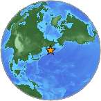
Magnitude 5.1 - KOMANDORSKIYE OSTROVA, RUSSIA REGION
2008 September 12 23:49:52 UTC
Earthquake Details
| Magnitude | 5.1 |
|---|---|
| Date-Time |
|
| Location | 56.219°N, 164.298°E |
| Depth | 10 km (6.2 miles) set by location program |
| Region | KOMANDORSKIYE OSTROVA, RUSSIA REGION |
| Distances | 155 km (95 miles) NW of Nikol'skoye, Komandorskiye Ostrova, Rus. 415 km (260 miles) S of Il'pyrskiy, Russia 510 km (315 miles) NE of Petropavlovsk-Kamchatskiy, Russia 6705 km (4160 miles) NNE of MOSCOW, Russia |
| Location Uncertainty | horizontal +/- 6 km (3.7 miles); depth fixed by location program |
| Parameters | NST=118, Nph=118, Dmin=510.2 km, Rmss=0.92 sec, Gp= 54°, M-type=body magnitude (Mb), Version=Q |
| Source |
|
| Event ID | us2008wwct |
- This event has been reviewed by a seismologist.
- Did you feel it? Report shaking and damage at your location. You can also view a map displaying accumulated data from your report and others.
Earthquake Maps
Earthquake Location
Location Maps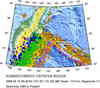
Historical Seismicity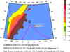
Seismic Hazard Map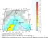
EQ Density Map
Google Map
Google Earth KML
(Requires Google Earth)- Did you feel it? Report shaking and damage at your location. You can also view a map displaying accumulated data from your report and others.
Scientific & Technical Information
 Historic Moment Tensor Solutions
- Preliminary Earthquake Report
- U.S. Geological Survey, National Earthquake Information Center:
World Data Center for Seismology, Denver
