 |
||||
|
|
|
|||


| |
Real-time Environmental Coastal Observations Network (RECON) Project
Steven A. Ruberg, Stephen B. Brandt
Collaborators
Tom Bridgeman, (Lake Erie
Center web site)
Guy Meadows, (University of Michigan web
site)
Harvey Bootsma, (University of Wisconsin-Milwaukee
web site)
Jeff Gray, (Thunder Bay National
Marine Sanctuary web site)
Anders Andren, Wisconsin Sea Grant, Univ. of Wisconsin (Wisconsin
Sea Grant web site)
Val Klump, National Undersea Research Program, University of Wisconsin
(NURP web site)
Charles Edmonson - (University
of Michigan Space Physics Research Lab web site)
Steven Gordon - (Ohio Supercomputer Center
web site)
Executive Summary 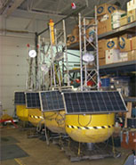
The goal of the RECON project is to develop a national network of low cost coastal buoys capable of seabed to sea-surface observations. The RECON system has been designed from the beginning with a built-in capability to add buoy observation sites to meet regional and national integrated observing system requirements. In addition to advancing NOAA's scientific real-time data acquisition capability, the project is making relevant data accessible to the public and educational institutions through a web-based data interface accessible using current internet technology with the goal of providing Internet 2 content. Permanent and portable wireless internet observation systems will be deployed at six sites for scientific data collection and continued engineering development in Lakes Huron and Erie.
Project Rationale
 The
need for development of regional coastal observing systems has been highlighted
by a number of studies as well as by the NOAA Strategic Plan (NOAA
Strategic Planning Office web site), the National Ocean Partnership
Program, and the U.S.
Coastal-Global Ocean Observing System program (C-GOOS
web site). Continual assessment of the status and trends in coastal
environments permits identification of perturbations that may signal changes
in the ecosystem, puts current trends into an historical framework, allows
us to differentiate true environmental change from variance and provides
a context to assess the impact of predicted changes.
The
need for development of regional coastal observing systems has been highlighted
by a number of studies as well as by the NOAA Strategic Plan (NOAA
Strategic Planning Office web site), the National Ocean Partnership
Program, and the U.S.
Coastal-Global Ocean Observing System program (C-GOOS
web site). Continual assessment of the status and trends in coastal
environments permits identification of perturbations that may signal changes
in the ecosystem, puts current trends into an historical framework, allows
us to differentiate true environmental change from variance and provides
a context to assess the impact of predicted changes.
Project Description
 While
legacy systems currently provide the majority of data for a national Integrated
Ocean Observing System (IOOS web site),
a high bandwidth system using commercial networking standards will be
required to provide real-time whole water column observations of physical,
chemical, and biological variables in coastal areas few, if any, environmental
observations. The RECON project will also include the development of autonomous
underwater vehicle technology and deployment of real-time in situ biological
and chemical sensors, including fisheries acoustics for biomass estimation,
in support of Ocean.US coastal priorities for IOOS. On-water observation
networks will include the development of fiber optic cabled and high-bandwidth
wireless systems utilizing advanced database management systems. The project
will establish a test bed for observing system network design studies
and develop enhanced verification capabilities as outlined in NOAA's 5-Year
Research Plan.
While
legacy systems currently provide the majority of data for a national Integrated
Ocean Observing System (IOOS web site),
a high bandwidth system using commercial networking standards will be
required to provide real-time whole water column observations of physical,
chemical, and biological variables in coastal areas few, if any, environmental
observations. The RECON project will also include the development of autonomous
underwater vehicle technology and deployment of real-time in situ biological
and chemical sensors, including fisheries acoustics for biomass estimation,
in support of Ocean.US coastal priorities for IOOS. On-water observation
networks will include the development of fiber optic cabled and high-bandwidth
wireless systems utilizing advanced database management systems. The project
will establish a test bed for observing system network design studies
and develop enhanced verification capabilities as outlined in NOAA's 5-Year
Research Plan.
Long Term Goals
- Collect long-term data sets for physical, biological, chemical, and meteorological parameters in the Great Lakes.
- Deploy observations systems on portable, low cost buoys and fixed platforms of opportunity.
- Implement a high bandwidth, wireless Ethernet-based system.
- Provide real-time, secure data access.
- Design universal sensor intefaces.
- Provide guest port access: data delivered to a common database or a single user.
- Develop partnerships with Federal, University, and State components to operate and maintain observations sites.
2006 goals
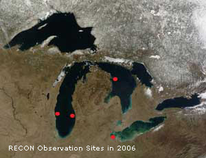
- Deploy and operate one RECON buoy at the Thunder Bay National Marine Sanctuary (TBNMS web site), one buoy in Western Lake Erie, and two buoys on Lake Michigan in conjunction with the NOAA Center For Great Lakes and Human Health.
- Operate two fixed stations on Coast Guard navigation structures in Western Lake Erie
- Complete the integration of two profilers into the Western Lake Erie RECON node
- Integrate buoys on Lake Huron and Lake Erie into the OSC designed real-time database management system and web display
- Determine buoy and permanent system reliability
- Demonstrate the capability to initiate sampling events using real-time observations
- Continue development of wireless internet system roaming, multiple access, and relay capabilities
- Establish laboratory calibration facility in collaboration with the Alliance for Coastal Technology (ACT web site)
2005 Results
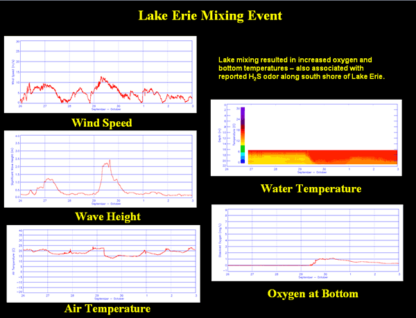
Two RECON buoys were assembled and deployed during the 2005 field season as planned. The two buoys were integrated with the existing RECON buoy located 15 statute miles north of Cleveland, OH. A wireless connection was achieved with the outermost buoy located 25 miles north of Cleveland. In 2006, all data will be accessible through a relational database management system interface.
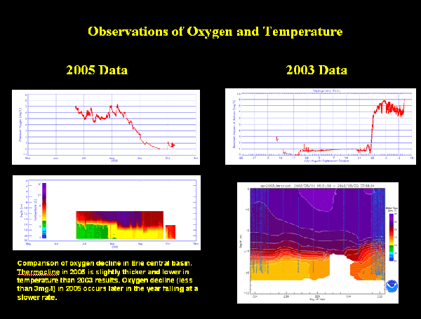
Sample Data
System Description
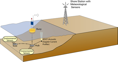
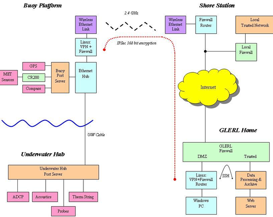
The RECON system currently in place in the Great Lakes has national and regional applications. This wireless Internet observation system, with shore stations at four coastal locations covering approximately 800 square miles of sea surface, uses commercially available networking equipment allowing straightforward integration into a nationwide network (see figure below). Each system collects meteorological data and provides sub-surface measurements of chemical, biological, and physical parameters. The system is designed to allow controlled access to multi-institutional users through surface buoys and sub-surface sensor guest ports located on an underwater hub. The observation network currently provides environmental data to state, federal, and university researchers, educators and resource managers. Overall, this type of effort will be an important contribution to NOAA's leadership in supporting and promoting observation system development.
Data Management and Communications
As NOAA's coastal observing system is put into place, there will be a need for an integrated set of data management and communications functions that will allow system users both real-time and archival access to the large datasets that will be created. The datasets will include an array of data types from physical and chemical measurements to biological information to video feeds of selected events.
![]()
![]()
Last updated 2006-09-22 mbl