Compiled
by the Office of NOAA Corps Operations
Page:
 1 2
3 4
5 6
7 8
9 10
11 12
13 14
1 2
3 4
5 6
7 8
9 10
11 12
13 14
NOAA
CORPS History of the
Wartime Experiences of the USS PATHFINDER
FORWARD
The following account of the wartime experiences of the USS PATHFINDER
has been compiled by the Office of NOAA Corps Operations of the National
Oceanic and Atmospheric Administration. This account has been excerpted
from a larger effort directed towards chronicling the history of the
NOAA Corps and its predecessor organizations which include the Commissioned
Corps of the Coast and Geodetic Survey, the Coast and Geodetic Survey,
the Coast Survey, and the Survey of the Coast dating back to 1807.
NARRATIVE
FIGHTING
WITH A SEXTANT
No half-breeds the hydrographers and chartmakers of the Southwest
and West Pacific. Because the war in the Pacific occurred in such
poorly charted waters, it readily became apparent to the Navy that
it would require the services of a cadre of hydrographers to rapidly
survey areas of tactical and strategic interest. Officers of the Coast
and Geodetic Survey provided the nucleus of that cadre and compiled
an enviable record of accomplishments from the Solomons to the Aleutians.
The ships they served on included the venerable HYDROGRAPHER and OCEANOGRAPHER,
the brand new PATHFINDER, the BOWDITCH, and even the ROCKY MOUNT,
Vice Admiral Richmond Kelly Turner's amphibious command ship. Of the
survey ships, the most illustrious of all was the PATHFINDER of which
it was said, "The road to Tokyo was paved with PATHFINDER charts."
The men
who served on these ships literally fought the war with sextants,
shooting millions of horizontal angles for three-point fixes while
operating fathometers or heaving the lead. Anchorages were wire-dragged,
invasion beaches surveyed before the U. S. Marines or Army landed,
tide information determined and provided to amphibious planners, tactical
operating areas delineated, passages blasted through coral reefs,
and charts printed and distributed to fleet units either in anticipation
of amphibious operations or to expedite the establishment of supply
and refitting bases. This work was not without its hazards as the
PATHFINDER alone was subjected to over 50 enemy bombing raids, shot
down 2 Japanese torpedo bombers, and was crashed by a kamikaze at
Okinawa. Numerous clandestine operations were carried out from these
vessels as well as from smaller craft attached to the hydrographic
units.
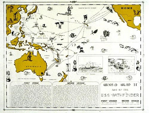
PATHFINDER
The PATHFINDER was in a Lake Washington, Seattle shipyard under construction
as the sister ship to the USC&GSS EXPLORER at the outbreak of
WWII. She was launched in 1942 with a champagne bottle broken across
the bow by Eleanor Roosevelt Boettiger, the 14-year-old granddaughter
of President Franklin Delano Roosevelt. The Navy immediately took
her over, designated her AGS1, fit her out with anti-aircraft guns,
depth charges, and a Navy crew and sent her out to Funafuti, Ellice
Islands, to survey the harbor and help clear obstructions as this
base was used as a staging area during the Guadalcanal-Solomon Islands
campaign. When the PATHFINDER first sailed, the captain was Captain
B. H. Thomas, USNR, while many of the other officers were on loan
to the Navy from the Coast and Geodetic Survey. Bill Gibson was Navigator/Operations
Office; Junius "Jerry" Jarman was data processing and chart production
officer; and numerous junior officers acquired survey data and were
boat OIC's. These included Ernie Stohsner, C. "Lon" Schoene, Walter
Chovan, and Edgar Hicks among others.
Following
the Funafuti survey, the ship moved down to Noumea, New Caledonia.
While there Ernie Stohsner was strolling through Noumea and ran into
his friend Lorin Woodcock directing a group of SeaBees constructing
a brig. This wasn't a very productive way for a C&GS hydrographer
to be spending his time so, as Schoene was being transferred to the
OCEANOGRAPHER, permission was asked for Woodcock to join the PATHFINDER.
Permission was granted and Woodcock joined the ship for the next 2
years. On February 2 the PATHFINDER sailed as an escort vessel for
a group of transports bound for Guadalcanal to resupply Marine and
Army units engaged there. After delivering the convoy, the ship proceeded
to Tulagi Harbor and commenced surveying operations. According to
Woodcock, the survey "was accomplished very expeditiously under the
most trying conditions. The field parties spent as much as 11 hours
a day in the field, and spent the nights alternating between working
on boat sheets and survey records, and manning battle stations while
from one to a half dozen Jap bombers droned about overhead, spattering
bombs here and there, sometimes uncomfortably close."
Having
finished Tulagi, the next job entailed inshore hydrography off the
coast of Guadalcanal from Point Cruz to Berande Point. At this time
all supplies were landed on Guadalcanal by lighter, and the purpose
of the survey was to determine anchorage areas as close inshore as
possible to expedite unloading operations. While conducting this survey,
the PATHFINDER had perhaps her finest hour. On April 7, 1943, no fewer
than 187 Japanese planes attacked Tulagi Harbor. During this action,
the PATHFINDER shot down two enemy dive bombers, assisted with two
others, and sustained two near misses which necessitated minor repairs
to the ship's rudder. Bill Gibson "was at the bridge conn during the
action keeping the ship on figure eight courses at flank speed, and
specifying targets to the bridge gun crews as the rapidly swinging
ship brought them into the various gun sectors." On one occasion the
ship was in a hard right turn and a bomb fell close aboard to port
right where the ship would have been had it remained on a straight
course.
During
this action, much of the ship's complement was out in survey launches
either wire dragging or conducting sounding lines. Ernie Stohsner
described his experience:
"The ship was out doing hydrography between Florida and Guadalcanal
Islands at the time. I had the wire drag out and was on the 30-foot
guide launch about two miles east of the ship. Our first knowledge
of the actual attack was a geyser of water next to the PATHFINDER
caused by the near-miss of a dive bomber. A number of planes pealed
out of the sun at the same time attacking aircraft in the vicinity
of the PATHFINDER. One of these escaped fire from the ships and came
directly towards us and commenced strafing. All personnel topside
dove over the side. The recorder, dragmaster, and myself were at the
plotting table below and did not have time to get out. Six machine
gun slugs hit the launch up forward within a few feet of us...."
The PATHFINDER
and its crew were not done for the day. Following the attack, the
PATHFINDER maneuvered to assist the stricken destroyer AARON WARD
which was doomed to soon sink. In describing the role of the PATHFINDER,
Admiral Chester W. Nimitz, Commander-in-Chief of the Pacific Fleet,
stated as follows:
"The
performance of PATHFINDER on 7 April is noteworthy. Preceding the
attack this vessel was conducting survey operations off Berande Point,
Guadalcanal. Despite warning of approaching planes and the departure
of most of our large ships from the area, her personnel continued
hydrography until enemy planes were near. Leaving her ship boats with
one quarter of the crew at their assigned survey duties, the commanding
officer then went to maximum speed and maneuvered close aboard AARON
WARD. Two planes dived on her and were shot down. Her boats brought
off wounded from AARON WARD who were cared for on board during the
night. Early next morning these men were disembarked for hospitalization
and at 0700, 8 April local time 'the ship resumed its survey operations.'
It is a pleasure to report on the efficient and business like conduct
of duty under fire of this USC&GS ship operating under my command."
During this attack, Lorin Woodcock was out on a survey launch and
observed two planes collide overhead. Two parachutes wafted down and
Woodcock directed his launch to the closest chute. Fortunately for
him, LST 449 beat him to the downed pilot who was Japanese and commenced
shooting at his would be captors. As Woodcock and his crew had neglected
to carry their standard issue weapons with them, they would have been
in quite a pickle if they had pulled that pilot out of the water.
As Captain Woodcock said during an interview, "I fought the war with
a sextant. I sure was lucky that time." As a footnote to history,
President-to-be John F. Kennedy was a junior officer on LST 449. Jerry
Jarman was in charge of the forward anti-aircraft guns on the PATHFINDER
as it pulled up to the AARON WARD and recalled "looking back at Kennedy's
ship while four dive bombers were attacking it. There were so many
exploding bombs along with the resulting water spouts that I could
not see the LST."
The PATHFINDER,
as well as being a combat survey ship, made many innovations and markedly
increased the efficiency of chart production and chart distribution
in the forward areas. Prior to sailing from the U.S., the Navy outfitted
the PATHFINDER with printing press, photographic equipment, and all
equipment necessary for printing charts in the field. The compilation
and publishing of charts aboard ship was never done prior to WWII.
A major obstacle to accomplishing this was that no one on board had
ever worked in a printing plant. Through the efforts of Jerry Jarman,
who read every available textbook on cartography and printing, the
PATHFINDER became the first vessel to ever publish Hydrographic Office
charts for distribution to fleet units. This bypassed the time-consuming
step of sending the data back to the United States for verification,
compilation, and final printing.
Jarman,
as well as devising the system that ended up producing charts, was
also a field hydrographer and went on numerous clandestine operations
in enemy-held waters including Manning Straits, Blanche Harbor in
the Treasury Islands, and Green Islands. He provided insight into
the requirements for combat tactical hydrographic surveys in a discussion
of the Manning Straits survey. This survey was conducted as a direct
result of the United States' naval defeat at the Battle of Savo Island.
According to Jarman, "Prior to that battle, a U.S. reconnaissance
plane had spotted an enemy Naval Task Force and noted its position.
From the data available, Intelligence estimated it would take this
force, travelling at flank speed, until at least 8 AM the following
morning to reach Guadalcanal." The Japanese arrived instead at 2 AM
and decimated a sleepy American Task Force behind Savo Island and
then withdrew. "Because the arrival of the enemy fleet was about six
hours earlier than expected, Intelligence figured the Japanese must
know of an uncharted shortcut. An inspection of area charts revealed
Manning Strait, although unsurveyed, might possibly be the shortcut
from Truk to Guadalcanal." This thinking caused Admiral "Bull" Halsey
to request the survey which resulted in finding an unknown (to the
Americans) passage through Manning Strait which was used successfully
by American vessels.
In the
Green Islands operation, Junius Jarman was attached to Naval Advance
Base Unit 11, a unit trained and organized to land with combat troops
and immediately begin functioning as a naval base. Jarman's job was
to lead an Advance Survey Party of four officers and seventeen men.
A reconnaissance force of approximately 400 men including two officers
and five men from Jarman's survey party landed on Nissan Atoll on
January 31, 1944, (D-15) at midnight and "departed twenty-four hours
later.... The entire force lost only five men killed and about ten
wounded during the twenty-four hour stay.... My group investigated
Middle and South Channels into the lagoon for least depth, ran a few
exploratory lines in an east-west direction across the lagoon, and
ran several sounding lines , north-south direction, along the shoreline
to assist in locating LST landing sites. We also obtained 24 hours
of tidal data to assist in estimating the tidal stage on D day.
"D day
for assaulting Nissan Atoll was February 15, 1944. Our forces met
with very little resistance on D day and the atoll was secure within
a week.... we found between 400 and 500 Japanese on the Atoll. They
were true Japanese in that not one of them surrendered, and all were
killed.... My small group remained at Green Islands from D day to
near the middle of March, 1944. During this period, a complete hydrographic
survey was made of Nissan Atoll, all shoals and channels were buoyed,
two permanent tide stations were established, and party members acted
as Pilots in getting supply vessels through South Channel.... The
base demolition squad was turned over to me and I was told to use
it as I saw fit. I had this squad reduce all dangerous coral heads,
and pointed out high spots in the entrance channels that needed reducing."
The PATHFINDER
continued on its illustrious career. Its largest single job was of
Seeadler Harbor in the Admiralty Islands. The ship accomplished this
work in the spring and summer of 1944. This particular survey was
for a very large base which became the staging area for the invasion
of the Philippines. In October 1944 the PATHFINDER returned to the
United States for repairs. On its first wartime cruise, this ship
developed the methodology for forward area chart production for immediate
distribution to fleet operating units, completed 20 major survey projects,
compiled 41 H.O. Field Charts, and published 62,077 copies for distribution.
The ship completed another 10 miscellaneous projects and published
approximately 20,000 copies of the resulting charts. The hydrographers
of the PATHFINDER had expanded tactical fleet operating areas, developed
port areas for major staging bases, and established safe channels
through the myriad islands of the southwest Pacific, The value of
this work to United States naval operations during the PATHFINDER's
first cruise was recognized by Admiral Chester Nimitz as follows:
"The
officers and men of the PATHFINDER are commended for their excellent
performance of survey duty in forward areas. It is especially noted
that PATHFINDER charts indicate accuracy of information and excellent
workmanship."
Admiral
William F."Bull" Halsey also commended the ship as follows:
"The
charts produced on board the PATHFINDER indicate excellent workmanship.
The men and officers are to be commended on their precision work carried
on in a forward area over a considerable length of time. Their efforts
have been most helpful to ships required to operate in waters previously
so inadequately charted."
Perhaps
the most fitting tribute for this cruise was stated by the ship's
commanding officer, Captain Bascom H. Thomas, who upon concluding
his report of activities of the ship from first arriving in the South
Pacific to September 22, 1944, wrote : "U.S.S. PATHFINDER arrived
in the South Pacific a new ship with an untrained crew. No one aboard
except the six U.S. Coast and Geodetic Survey Officers had ever had
any experience in hydrographic surveying and they had none in planning
and laying out of surveys, chart compilation and publication, or the
establishing of aids to navigation such as beacons and buoys. The
Commanding Officer was the only officer who had any experience in
Navy organization, operations and procedure other than short training
courses. A majority of the crew had never been to sea. There have
been few breaches of discipline and none of a serious nature. All
hands have worked diligently and faithfully to establish the PATHFINDER's
unequalled record. They merit the utmost credit for the results."
The PATHFINDER
left shipyard in San Francisco and returned to the western Pacific
on December 18, 1944, under the command of Commander Francis L. Dubois,
USNR. Jerry Jarman was now executive officer and the only C&GS
officer on board although he was detached upon arrival at Guam. The
Coast and Geodetic Survey connection continued though, as Ensign Henry
V. Oheim, USNR, of the Baltimore Field Office and Lieutenant Commander
Samuel N. Davis, USNR, the chief engineer and engineer on C&GS
ships since 1919 remained with the ship for the duration of the war.
The ship
arrived at Guam in late January 1945 and then proceeded to an area
reported as discolored water about 350 miles north of Guam. Here,
in the course of surveying what even to this day is named Pathfinder
Reef, the PATHFINDER gained the distinction of being the American
vessel that anchored the closest to Japan since the beginning of hostilities.
In late March, the PATHFINDER was sent to the east coast of Luzon,
Philippine Islands, and helped liberate the village of Casiguran.
On March 13, 1945, a landing party was put ashore from the PATHFINDER
which surprised the Japanese who deserted their machine gun emplacements
and fled into the surrounding hills. On March 28th the ship was bombed
by two Japanese dive bombers; but, once again, its luck held out.
The first plane dropped two bombs about 30 yards off the port bow.
By this time the ship was at general quarters and the starboard 3-inch
gun hit the second plane causing it to pull out of its dive smoking.
The plane was last seen proceeding over the mountains to the west.
Finishing
the Luzon job, the ship sailed to Ulithi anchorage where it stayed
for 3 weeks prior to departing for Okinawa. On May 1 she sailed into
Hagushi Anchorage, Okinawa. May 6 the PATHFINDER's luck was sorely
tested at Suicide Slot, Sesoko; the ship was attacked by two kamikaze
planes. The first managed to crash the after port 40-mm gun platform,
killing one crewman. Fortunately, the 500-pound bomb the plane was
carrying did not detonate or,in all probability, the ship would have
been sunk with much greater loss of life. The ship fought off the
second kamikaze which veered off and crashed into an LST at Ie Shima.
From her arrival at Okinawa until cessation of hostilities, the PATHFINDER
went to general quarters 170 times; those sent ashore for work at
Nago Wan endured foxhole watches, sniper fire, and mortar bombardment.
As Henry Oheim wrote of this period, "... the gunnery activity of
the PATHFINDER at night far exceeded the survey activity during the
day...." But not one more PATHFINDER crewman was scratched. On August
10, with hints of peace coming to the great fleet at Hagushi Anchorage,
a great barrage of firepower was unleashed in celebration which the
PATHFINDER was there to witness. The end had come at last. In spite
of surviving over 50 bombing attacks, being declared sunk at least
six times by Tokyo Rose, and having surveyed many western Pacific
islands, anchorages, passages, and operating areas in advance of the
fleet, the PATHFINDER was there for the victory.
October
13, 1945, found the PATHFINDER at Yokosuka Naval Base in Tokyo Bay.
The ship wound up its Navy career conducting a series of surveys in
the Tokyo Bay area. She left Japan on December 5, 1945, and arrived
in Seattle, Washington, on December 24. On January 31, 1946, she was
decommissioned and thence returned to commission as the Coast and
Geodetic Survey Ship PATHFINDER on August 22, 1946. She served as
a survey ship in Alaskan, Hawaiian, and Pacific Coast waters for the
next 25 years, and was deactivated in December 1971.
- Top of Page -