Summer 2008 Climate Statistics
Bismarck
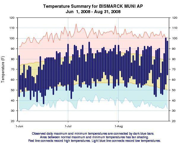
Temperatures for the 2008 summer season (defined as the months of June-July-August) at the Bismarck airport averaged 68.6 degrees which was nearly one degree above 1971 to 2000 climatological average. This happened in spite of a relatively cool June. During the month of June, the average temperature was 62.0 degrees which was 2.7 degrees below normal. No 90 degree temperatures were experienced during June, when on average, there are around 2 days of 90 degree temperatures. The maximum temperature finally broke 90 degrees on the first of July. During the months of July and August the mercury topped 90 degrees on 20 days. On average, fifteen 90+ degree days are experienced during July and August. Overall, the warmest temperature experienced during the summer season was 100 degrees which occurred on the 30th of August. This was the only day of triple digit heat during the summer. The lowest temperature during the summer season was 37 degrees on the 16th of June.
Precipitation for the 2008 summer season at Bismarck airport was 7.89 inches which was 1.39 inches above the 1971 to 2000 average. In addition, the number of days with measureable rainfall (defined as rainfall amounts of at least one hundredth of an inch) was above average for the summer season, with one calendar day having a total exceeding one inch (near average). There were 27 thunderstorm days reported this summer, with one instance of hail noted at the airport.
...THE BISMARCK ND CLIMATE SUMMARY FOR THE SEASON, FROM
*Trace of pea size hail reported on July 31st at the Weather Forecast Office.

Williston
Temperatures for the 2008 summer season (defined as the months of June-July-August) at the Williston airport averaged 67.5 degrees which was near the 1971 to 2000 climatological average of 67.1 degrees. This happened in spite of a relatively cool June. During the month of June, the average temperature was 61.3 degrees which was 2.4 degrees below normal. Only one calendar day during the month exceeded 90 degrees, when on average, there are around 3 days of 90 degree temperatures. However, during the months of July and August temperatures were warmer than average. During these months, the mercury topped 90 degrees on 20 days. On average, fifteen 90+ degree days are experienced during July and August. Overall, the warmest temperature experienced during the summer season was 101 degrees which occurred on the 1st of August. This was the only day of triple digit heat during the summer. The lowest temperature during the summer season was 35 degrees on the 8th of June.
Precipitation for the 2008 summer season at Williston airport was 4.42 inches which was 1.70 inches below the 1971 to 2000 average. In spite of this, the number of days with measureable rainfall (defined as rainfall amounts of at least one hundredth of an inch) was typical for the summer season. However, there was only one heavy rainfall event that exceeded 0.50 inch of rainfall on the 11th of June. There were no calendar days having a total exceeding one inch. There were 25 thunderstorm days reported this summer, with one instance of hail noted at the airport.
...THE WILLISTON ND CLIMATE SUMMARY FOR THE SEASON, FROM
6/1/2008 TO 8/31/2008...
CLIMATE NORMAL PERIOD 1971 TO 2000
CLIMATE RECORD PERIOD 1894 TO 2008
WEATHER OBSERVED NORMAL DEPART LAST YEAR'S
VALUE DATE(S) VALUE FROM VALUE DATE(S)
NORMAL
................................................................
TEMPERATURE (F)
RECORD
HIGH 110 07/05/1936
LOW 26 06/04/1998
HIGHEST 101 08/01 MM MM MM MM
LOWEST 35 06/08 MM MM MM MM
AVG. MAXIMUM 82.4 81.2 1.2 MM
AVG. MINIMUM 52.7 53.1 -0.4 MM
MEAN 67.5 67.1 0.4 MM
DAYS MAX >= 90 21 19.8 1.2 MM
DAYS MAX <= 32 0 0.0 0.0 MM
DAYS MIN <= 32 0 0.2 -0.2 MM
DAYS MIN <= 0 0 0.0 0.0 MM
PRECIPITATION (INCHES)
TOTALS 4.42 6.12 -1.70 MM
DAYS >= .01 27 27.6 -0.6 MM
DAYS >= .10 12 13.7 -1.7 MM
DAYS >= .50 1 3.4 -2.4 MM
DAYS >= 1.00 0 0.8 -0.8 MM
GREATEST
24 HR. TOTAL 0.94 MM MM
STORM TOTAL MM MM
(MM/DD(HH)) MM MM
SNOWFALL (INCHES)
RECORDS
TOTAL *T 2008
TOTALS *T T
DEGREE_DAYS
HEATING TOTAL 168
COOLING TOTAL 433
.................................................................
WIND (MPH)
HIGHEST WIND SPEED/DIRECTION 54/320 DATE 07/28
HIGHEST GUST SPEED/DIRECTION 66/310 DATE 07/28
SKY COVER
POSSIBLE SUNSHINE (PERCENT) 75
NUMBER OF DAYS FAIR 77
NUMBER OF DAYS PC 11
NUMBER OF DAYS CLOUDY 4
AVERAGE RH (PERCENT) 57
WEATHER CONDITIONS. NUMBER OF DAYS WITH
THUNDERSTORM 25 MIXED PRECIP 0
HEAVY RAIN 6 RAIN 14
LIGHT RAIN 43 FREEZING RAIN 0
LT FREEZING RAIN 0 HAIL 1
HEAVY SNOW 0 SNOW 0
LIGHT SNOW 0 SLEET 0
FOG 17 FOG W/VIS <= 1/4 MILE 0
HAZE 5
- INDICATES NEGATIVE NUMBERS.
R INDICATES RECORD WAS SET OR TIED.
MM INDICATES DATA IS MISSING.
T INDICATES TRACE AMOUNT.
*Trace of pea size hail reported on June 19th at the Weather Office.


Dickinson
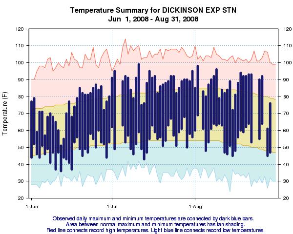
Temperatures for the 2008 summer season (defined as the months of June-July-August) at the Dickinson airport averaged 67.0 degrees which was near the 1971 to 2000 climatological average of 67.4 degrees. This happened in spite of a relatively cool June. During the month of June, the average temperature was 60.2 degrees which was 3.2 degrees below normal. Only one calendar day during the month exceeded 90 degrees, when on average, there are around 2 days of 90 degree temperatures. However, during the months of July and August temperatures were on the warm side of average. During these months, the mercury topped 90 degrees on 24 days. On average, sixteen 90+ degree days are experienced during July and August. Overall, the warmest temperature experienced during the summer season was 101 degrees which occurred on the 30th of August. This was one of only two calendar days in which triple digit heat was reported during the summer. The lowest temperature during the summer season was 37 degrees on the 11th of June.
Precipitation for the 2008 summer season at Dickinson airport was 5.14 inches which was 1.62 inches below the 1971 to 2000 average. In spite of this, the number of days with measureable rainfall (defined as rainfall amounts of at least one hundredth of an inch) was typical for the summer season. However, there were no heavy rainfall events which exceeded 1.00 inch of rainfall during the summer season. There were 24 thunderstorm days reported this summer.
...THE DICKINSON ND CLIMATE SUMMARY FOR THE SEASON, FROM
6/1/2008 TO 8/31/2008...
CLIMATE NORMAL PERIOD 1971 TO 2000
CLIMATE RECORD PERIOD 1903 TO 2008
WEATHER OBSERVED NORMAL DEPART LAST YEAR'S
VALUE DATE(S) VALUE FROM VALUE DATE(S)
NORMAL
................................................................
TEMPERATURE (F)
RECORD
HIGH 114 07/06/1936
LOW 26 08/28/1911
HIGHEST 101 08/30 MM MM MM MM
LOWEST 37 06/11 MM MM MM MM
AVG. MAXIMUM 82.1 80.9 1.2 MM
AVG. MINIMUM 51.8 53.8 -2.0 MM
MEAN 67.0 67.4 -0.4 MM
DAYS MAX >= 90 25 MM MM MM
DAYS MAX <= 32 0 MM MM MM
DAYS MIN <= 32 0 MM MM MM
DAYS MIN <= 0 0 MM MM MM
PRECIPITATION (INCHES)
TOTALS 5.14 6.76 -1.62 MM
DAYS >= .01 32 MM MM MM
DAYS >= .10 13 MM MM MM
DAYS >= .50 4 MM MM MM
DAYS >= 1.00 0 MM MM MM
GREATEST
24 HR. TOTAL 0.68 MM MM
STORM TOTAL MM MM
(MM/DD(HH)) MM MM
SNOWFALL (INCHES)
RECORDS
TOTAL 0.0 2001
TOTALS MM T
DEGREE_DAYS
HEATING TOTAL 212
COOLING TOTAL 426
.................................................................
WIND (MPH)
HIGHEST WIND SPEED/DIRECTION 49/290 DATE 07/11
HIGHEST GUST SPEED/DIRECTION 58/290 DATE 07/11
SKY COVER
POSSIBLE SUNSHINE (PERCENT) MM
NUMBER OF DAYS FAIR 77
NUMBER OF DAYS PC 11
NUMBER OF DAYS CLOUDY 4
AVERAGE RH (PERCENT) 58
WEATHER CONDITIONS. NUMBER OF DAYS WITH
THUNDERSTORM 24 MIXED PRECIP 0
HEAVY RAIN 12 RAIN 10
LIGHT RAIN 39 FREEZING RAIN 0
LT FREEZING RAIN 0 HAIL 0
HEAVY SNOW 0 SNOW 0
LIGHT SNOW 0 SLEET 0
FOG 22 FOG W/VIS <= 1/4 MILE 1
HAZE 6
- INDICATES NEGATIVE NUMBERS.
R INDICATES RECORD WAS SET OR TIED.
MM INDICATES DATA IS MISSING.
T INDICATES TRACE AMOUNT.
...................................

Minot
Temperatures for the 2008 summer season (defined as the months of June-July-August) at the Minot airport averaged 66.2 degrees which was just over a degree below the 1971 to 2000 climatological average of 67.4 degrees. This was due in large part to a relatively cool June. During the month of June, the average temperature was 60.8 degrees which was 3.6 degrees below the average. No 90 degree temperatures were experienced during June, when on average, there are around 2 days of 90 degree temperatures. The maximum temperature finally broke 90 degrees on the fifth of July. During the months of July and August the mercury topped 90 degrees on 9 days. On average, around eleven 90+ degree days are experienced during July and August. Overall, the warmest temperature experienced during the summer season was 97 degrees which occurred on the 31st of August. There was no triple digit heat during the summer. The lowest temperature during the summer season was 40 degrees on the 10th of June.
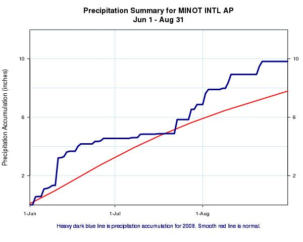
Precipitation for the 2008 summer season at Minot airport was 9.83 inches which was 2.28 inches above the 1971 to 2000 average. In addition, the number of days with measureable rainfall (defined as rainfall amounts of at least one hundredth of an inch) was very typical for the summer season, with one calendar day having a total exceeding one inch (near average). There were 25 thunderstorm days reported this summer.
...THE MINOT ND CLIMATE SUMMARY FOR THE SEASON, FROM
6/1/2008 TO 8/31/2008...
CLIMATE NORMAL PERIOD 1971 TO 2000
CLIMATE RECORD PERIOD 1905 TO 2008
WEATHER OBSERVED NORMAL DEPART LAST YEAR'S
VALUE DATE(S) VALUE FROM VALUE DATE(S)
NORMAL
................................................................
TEMPERATURE (F)
RECORD
HIGH 109 07/11/1936
06/20/1910
LOW 24 06/16/1915
HIGHEST 97 08/31 MM MM MM MM
LOWEST 40 06/10 MM MM MM MM
AVG. MAXIMUM 78.9 79.5 -0.6 MM
AVG. MINIMUM 53.5 55.3 -1.8 MM
MEAN 66.2 67.4 -1.2 MM
DAYS MAX >= 90 9 MM MM MM
DAYS MAX <= 32 0 MM MM MM
DAYS MIN <= 32 0 MM MM MM
DAYS MIN <= 0 0 MM MM MM
PRECIPITATION (INCHES)
TOTALS 9.83 7.55 2.28 MM
DAYS >= .01 33 MM MM MM
DAYS >= .10 19 MM MM MM
DAYS >= .50 8 MM MM MM
DAYS >= 1.00 1 MM MM MM
GREATEST
24 HR. TOTAL 1.88 MM MM
STORM TOTAL MM MM
(MM/DD(HH)) MM MM
SNOWFALL (INCHES)
RECORDS
TOTAL 0.0
TOTALS MM T
DEGREE_DAYS
HEATING TOTAL 177
COOLING TOTAL 316
.................................................................
WIND (MPH)
HIGHEST WIND SPEED/DIRECTION 47/280 DATE 06/14
HIGHEST GUST SPEED/DIRECTION 67/270 DATE 06/14
SKY COVER
POSSIBLE SUNSHINE (PERCENT) MM
NUMBER OF DAYS FAIR 77
NUMBER OF DAYS PC 11
NUMBER OF DAYS CLOUDY 4
AVERAGE RH (PERCENT) 62
WEATHER CONDITIONS. NUMBER OF DAYS WITH
THUNDERSTORM 25 MIXED PRECIP 0
HEAVY RAIN 12 RAIN 22
LIGHT RAIN 40 FREEZING RAIN 0
LT FREEZING RAIN 0 HAIL 0
HEAVY SNOW 0 SNOW 0
LIGHT SNOW 0 SLEET 0
FOG 45 FOG W/VIS <= 1/4 MILE 5
HAZE 21
- INDICATES NEGATIVE NUMBERS.
R INDICATES RECORD WAS SET OR TIED.
MM INDICATES DATA IS MISSING.
T INDICATES TRACE AMOUNT.
...................................

Jamestown
Temperatures for the 2008 summer season (defined as the months of June-July-August) at the Jamestown airport averaged 66.1 degrees which was just over two degrees below the 1971 to 2000 climatological average of 68.4 degrees. This was due in large part to a relatively cool June. During the month of June, the average temperature was 61.9 degrees which was 3.5 degrees below the average. No 90 degree temperatures were experienced during June, when on average, there are around 3 days of 90 degree temperatures. The maximum temperature finally broke 90 degrees on the first of July. During the months of July and August the mercury topped 90 degrees only on 3 days. On average, around thirteen 90+ degree days are experienced during July and August. Overall, the warmest temperature experienced during the summer season was 93 degrees which occurred on the 1st of July. There was no triple digit heat during the summer. The lowest temperature during the summer season was 40 degrees on the 24th of August.
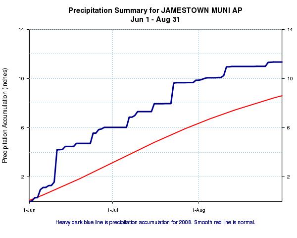
Precipitation for the 2008 summer season at Jamestown airport was 11.35 inches which was 3.53 inches above the 1971 to 2000 average. In addition, the number of days with measureable rainfall (defined as rainfall amounts of at least one hundredth of an inch) was higher than normal for the summer season, with two calendar days having rainfall amounts exceeding one inch. There were 20 thunderstorm days reported this summer.
...THE JAMESTOWN ND CLIMATE SUMMARY FOR THE SEASON, FROM
6/1/2008 TO 8/31/2008...
CLIMATE NORMAL PERIOD 1971 TO 2000
CLIMATE RECORD PERIOD 1891 TO 2008
WEATHER OBSERVED NORMAL DEPART LAST YEAR'S
VALUE DATE(S) VALUE FROM VALUE DATE(S)
NORMAL
................................................................
TEMPERATURE (F)
RECORD
HIGH 118 07/06/1936
LOW 27 06/02/1910
HIGHEST 93 07/01 MM MM MM MM
LOWEST 40 08/24 MM MM MM MM
AVG. MAXIMUM 78.1 81.3 -3.2 MM
AVG. MINIMUM 54.1 55.4 -1.3 MM
MEAN 66.1 68.4 -2.3 MM
DAYS MAX >= 90 3 MM MM MM
DAYS MAX <= 32 0 MM MM MM
DAYS MIN <= 32 0 MM MM MM
DAYS MIN <= 0 0 MM MM MM
PRECIPITATION (INCHES)
RECORD
MAXIMUM 12.71 2001
MINIMUM 11.35 2008
TOTALS 11.35R 7.82 3.53 MM
DAYS >= .01 37 MM MM MM
DAYS >= .10 20 MM MM MM
DAYS >= .50 7 MM MM MM
DAYS >= 1.00 2 MM MM MM
GREATEST
24 HR. TOTAL 2.89 MM MM
STORM TOTAL MM MM
(MM/DD(HH)) MM MM
SNOWFALL (INCHES)
RECORDS
TOTAL 0.0 2001
TOTALS MM T
DEGREE_DAYS
HEATING TOTAL 152
COOLING TOTAL 285
.................................................................
WIND (MPH)
HIGHEST WIND SPEED/DIRECTION 47/080 DATE 06/11
HIGHEST GUST SPEED/DIRECTION 62/070 DATE 06/11
SKY COVER
POSSIBLE SUNSHINE (PERCENT) MM
NUMBER OF DAYS FAIR 73
NUMBER OF DAYS PC 10
NUMBER OF DAYS CLOUDY 9
AVERAGE RH (PERCENT) 68
WEATHER CONDITIONS. NUMBER OF DAYS WITH
THUNDERSTORM 20 MIXED PRECIP 0
HEAVY RAIN 11 RAIN 19
LIGHT RAIN 39 FREEZING RAIN 0
LT FREEZING RAIN 0 HAIL 0
HEAVY SNOW 0 SNOW 0
LIGHT SNOW 0 SLEET 0
FOG 39 FOG W/VIS <= 1/4 MILE 12
HAZE 12
- INDICATES NEGATIVE NUMBERS.
R INDICATES RECORD WAS SET OR TIED.
MM INDICATES DATA IS MISSING.
T INDICATES TRACE AMOUNT.
...................................

All images were reproduced from xmACIS.
Return to Latest News