 |
||||
|
|
 |
||


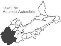
Great Lakes Resource Shed Maps: Watershed Moisture
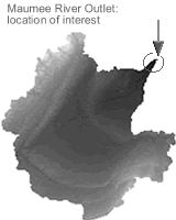
Resource sheds delineate the areal distribution of materials, originating over a time interval, prior to their passage through a location of interest at the end of the time interval. For a watershed, a significant location of interest is the watershed's outlet.
The images presented below depict previous days' areal distributions of source watershed moisture comprising watershed outflow on selected outflow dates. The RELATIVE data type expresses source material as a percentage of the outflow on the selected day and the ABSOLUTE data type expresses it in cubic meters per day. The resolution of the maps is 1 km2. These images allow a visual comparison of areal and temporal moisture contributions for an outflow date and offer broad utility in interpreting watershed events.
There is software available for the user to build their own maps from
the downloadable data sets. The zipped file contains complete documentation
and test data files.
[download
software]
To examine a resource shed of interest, select a watershed, year/month, outflow date, data type, and scale, and then press the "Select Image Series" button. Units in the 'relative' data sets are unitless fractions. Absolute data set units are cm/day.
 |  | Downloading Data Downloading Images Data Disclaimer |
 1 days prior Outflow Date: 20080911 + data file |  2 days prior Outflow Date: 20080911 + data file |  3 days prior Outflow Date: 20080911 + data file | 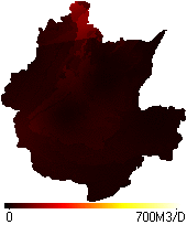 4 days prior Outflow Date: 20080911 + data file |
 5 days prior Outflow Date: 20080911 + data file |  6 days prior Outflow Date: 20080911 + data file | 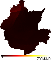 7 days prior Outflow Date: 20080911 + data file | 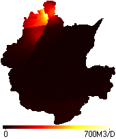 8 days prior Outflow Date: 20080911 + data file |
 9 days prior Outflow Date: 20080911 + data file |  10 days prior Outflow Date: 20080911 + data file |  11 days prior Outflow Date: 20080911 + data file |  12 days prior Outflow Date: 20080911 + data file |
 13 days prior Outflow Date: 20080911 + data file |  14 days prior Outflow Date: 20080911 + data file |  15 days prior Outflow Date: 20080911 + data file |
![]()
Last updated: 2008-07-31 ahc