


Operations Updates
ARM Climate Research Facility Operations Update - July 15, 2005
This bimonthly report provides a brief summary of significant accomplishments and activities in the operations area of the ARM Climate Research Facility (ACRF).
Battle With Bugs Nearly Over Thanks to New Radar
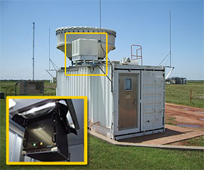
The new W-band ARM cloud radar, or WACR, provides improved sensitivity for detecting tiny objects in the atmosphere to an altitude of 5 km. The instrument's antenna is located adjacent to the millimeter wave cloud radar (MMCR) antenna on top of the MMCR shelter; the rest of the unit is located inside (inset).
The main purpose of the millimeter wavelength cloud radar (MMCR) is to measure cloud boundaries (i.e., cloud tops and bottoms), and to record the reflectivity profile of the atmosphere up to 20 km. Unfortunately, for a great portion of the year at the ACRF Southern Great Plains (SGP) site, data from the MMCR are often contaminated by "atmospheric plankton" (tiny bugs and dust particles) at altitudes up to 5 km. Researchers analyzing MMCR data from several experiments concluded that trying to differentiate between the clouds and atmospheric plankton with the current set of instruments was extremely time consuming and inexact. To solve this dilemma, a new W-band ARM cloud radar (WACR) was designed and built during the past year, and was installed in the MMCR instrument shelter at the SGP Central Facility in early July.
Built by ProSensing, the WACR is a Doppler radar that returns signals of reflectivity, velocity, and spectral width (which corresponds to turbulence). Both the WACR and MMCR have co-polarization and cross-polarization channels to differentiate between spherical (e.g., raindrops) and nonspherical (e.g., insects and ice crystals) atmospheric objects, but the new radar operates at 95 GHz, whereas the MMCR operates at 35 GHz. The new radar complements the existing MMCR by differentiating between clouds and spurious radar returns due to insects and other detritus in the lower atmosphere. By collocating these two radars and their various modes of operation, researchers will now have the data to explore dual wavelength techniques such as retrieval of drizzle parameters, etc. Deployment of the WACR represents a key milestone for user enhancements at the SGP Central Facility.
New Data Streams Available for ARM Mobile Facility Deployment Sites

The pyeruc20isobX1.c1 data stream originates from data in a grid of points bordered by latitudes 34.300 and 42.539 and by longitudes -127.607 and -120.862; the RUC "bounding box." This area is indicated by the blue corner squares; purple dots indicate MOLTS stations, and green triangles indicate ECMWF stations. (Click for a larger version of the image.)
New climate data streams are now available from Point Reyes National Seashore in California, where the first deployment of the ARM Mobile Facility is currently underway, and for the site of the ARM Mobile Facility's next deployment at Niamey, Niger, Africa. The new data streams, which are supplementary to the data streams obtained by the Mobile Facility instruments, provide climate information as netCDF files for use by ARM researchers.
For climate analyses of Point Reyes National Seashore and the surrounding area, the pyeruc20isobX1.c1 data stream, provided by the National Centers for Environmental Prediction (NCEP), offers output of the Rapid Update Cycle (RUC) model, an atmospheric prediction system that was developed to serve users needing short-range weather forecasts. RUC provides a 3-D objective analysis, updated every hour, over the contiguous United States and assimilates data from a variety of aircraft, satellite, and ground-based sources. A separate series of data streams, specifically generated for ARM analysis, is supplied by the European Centre for Medium Range Weather Forecasts (ECMWF) and has been available continuously since April 2005 for Point Reyes National Seashore, and since May 2005 for Niamey. Whereas the RUC data stream offers information for a grid of points (see figure), the ECMWF streams are limited to specific points on the map: (38.11 N, 123.33 W) at Point Reyes, and (2.46 N, 13.52 W) at Niamey and (38.11 N, 122.92 W). The RUC and ECMWF data streams use different algorithms and include slightly different measurements.
Another dataset, the Model Output Location Time Series (MOLTS), is also now available for the Point Reyes area. Measurements included are products of NCEP's mesoscale numerical weather prediction model and its associated 4-D data assimilation system. These data are the hourly output at selected locations containing values for various surface parameters and "sounding" output at model levels. The MOLTS stations included in the surface (pyemoltsedassfcclass1X1.a1) and sounding (pyemoltsedassndclass1X1.a1) data streams are from the same approximate area as the RUC stations-a large portion of the West Coast centered on Point Reyes. More information can be accessed at http://www.arm.gov/xds/static/ruc.stm for the RUC data stream, http://www.arm.gov/xds/static/ecmwf.stm for those from ECMWF, and http://www.arm.gov/xds/static/molts.stm for the MOLTS data streams.
ACRF Capabilities Promoted at Air & Waste Management Conference
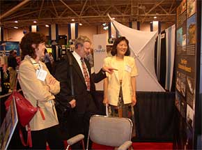
From left, Dr. Sylvia Edgerton, Science Liaison for the ACRF Science Board, Dr. John Watson, Research Professor at the Desert Research Institute, and Dr. Judith Chow, Research Professor at the Desert Research Institute and member of the ACRF Science Board, discuss the ACRF display during the A&WMA conference.
Approximately 2,500 environmental professionals attended the 98th annual Air & Waste Management (A&WMA) conference and exhibition that took place June 21-24 in Minneapolis. Exhibiting for the first time at the conference, ACRF staff provided extensive background information about the ARM science program and the transition to a national user facility. Several inquiries about data, measurements, and how research could be conducted at the ACRF sites resulted from the meeting. More than 100 attendees, representing such countries as Jamaica, Taiwan, Mexico, Canada, Australia, New Zealand, Korea, Russia, and Japan asked questions about the ACRF and the upcoming ARM Mobile Facility deployment in Africa in 2006.
On the second day of the conference, Dr. Sylvia Edgerton, Science Liaison for the ACRF Science Board, gave a 15-minute presentation in the exhibit hall that focused on the ACRF, including opportunities for its use. The audience inquired about the use of ACRF instruments, how to submit proposals, and asked questions about the ARM Mobile Facility. Also during the conference, Dr. Edgerton was selected as Chair of the A&WMA Editorial Review Board, which oversees the editorial staff of the Journal of the A&WMA, as well as all issues related to its publication.
The annual A&WMA conference is considered a premier environmental education, networking, and solutions event. The A&WMA is a nonprofit, nonpartisan professional organization that provides technology exchange, training, networking opportunities, and public outreach to more than 9,000 environmental professionals in 65 countries.