
If you are using
Navigator 4.x
or
Internet Explorer 4.x
or
Omni Web 4.x
, this site will not render
correctly!
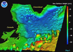
Shown are instantaneous sea surface height (shaded)
and near-surface current velocities (vectors).
More accurate representation of ocean eddies and transports
will lead to an improvement in the ocean component of
coupled ocean-atmosphere models.
See this section
from a presentation given at SuperComputing '99.
| North Atlantic Circulation | Sea Surface Height |
|
See enlargments below. |
|

| Low Resolution Model | High Resolution Model | High Resolution Model Detail |
|
|
|
|


| Model | |
| Model Name: | N/A |
| Environment | |
| Data Size: | N/A |
| Computer: | N/A |
| Runtime: | N/A |
| Domain | |
| Horizontal Resolution: | N/A |
| Vertical Resolution: | N/A |
| Levels: | N/A |
| Project | |
| Scientists: | N/A |
| Date Created: | N/A |
| Visualization | |
| Personnel: | N/A |
| Software: | Iris Explorer |