|
OSM receives award for adapting technology to help protect lives and the environment
San Diego, California —
Many of the nearly 15,000 scientists, researchers, business leaders and government officials gathered for an international geographic information systems (GIS) conference watched as OSM was recognized for its vision and leadership in using technology to make the Nation’s coal mines safer for the public and to protect the environment.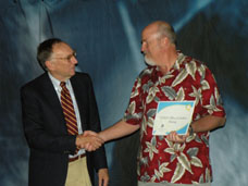
Description of Photo: Jack Dangermond (left), President of ESRI, congratulates OSM’s Greg Morlock on the bureau’s vision and leadership in using geographic information systems (GIS) to make the Nation’s coal mines safer for the public and to help protect the environment. Morlock accepted the Special Achievement in GIS (SAG) Award on behalf of OSM’s team working to build a central repository for boundaries of abandoned and active coalmines. OSM Photo
While OSM has long promoted efforts to utilize sound science and cutting-edge technology to ensure the safe extraction of coal and the successful reclamation of coal mine sites, this may be the single largest group ever to see OSM’s efforts recognized.
Earning the spotlight was an OSM pilot project to use geographic information system technology to create a national centralized repository for boundaries of abandoned and active coal mines collected in real time from servers in multiple state locations.
There is no central repository for this coal mining spatial data. Currently, a person would have to visit 26 state regulatory agencies and several federal agencies if they wanted nationwide information. Mine sites bordering multiple states might have its permit information located only in one state thus creating a dangerous blind spot for people in the adjoining states.
OSM saw GIS as the solution for quickly and accurately collecting this wide-spread coal mining spatial data. Once collected, this data can be used in many ways. GIS combines computer hardware, software, and data to create tools for capturing, managing, analyzing, and displaying all forms of geographic information.
As members of a seven-person OSM team, Greg Morlock and Alan Wilhelm worked with the Virginia Department of Mines, Minerals and Energy, West Virginia’s Department of Environmental Protection, and OSM’s Knoxville Field Office in Tennessee. These three states provided access through the Intenet to their coal mining spatial databases. Coal mining spatial data from Arizona, Colorado, Montana, New Mexico, and Washington state were accessed from an internal server located at OSM’s Denver office.
During the prototyping effort, nearly 8,000 coal mining permit boundaries were downloaded from four servers, reprojected to a common coordinate system, and merged in real time in 5.5 minutes to create the first national coal mining spatial dataset mapping permit boundaries in eight states. The project has shown that bringing together disparate coal mining spatial data from the different states, tribes, and the OSM is possible.
This pilot project demonstrates that this technology could be used nationwide. OSM will now evaluate other hurdles that exist to using this process nationwide. If completed nationally, Internet users will be able to individually create and explore maps at their workstations based on authentic data from all the participating state, tribal and federal agencies. Regulators and the public would be able to obtain useful information from the national data regardless of the agency databases from which it originated.
OSM was recognized for this innovative use of GIS with the Special Achievement in GIS (SAG) Award recently during the 28th Annual ESRI International User Conference (ESRI UC) here.
More News and Stories
|