IfSAR
Summary | Different Data Products | Applied Uses | Specifications | Data Ordering Details | Frequently Asked Questions | For More Information
To browse elevation data available for download or learn more about topographic mapping activities at the NOAA Coastal Services Center, please visit
our Topographic Change Mapping home page.
Summary
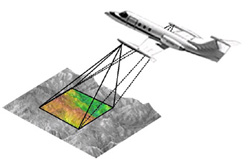
Interferometric Synthetic Aperture Radar (IfSAR or InSAR) is an
aircraft-mounted sensor designed to measure surface elevation, which
is used to produce topographic imagery. Radar pulses are aimed at targets
on the Earth, and the return ground signals are received by two antennas
that record elevations (z) at specific ground coordinates (x,y).
The ground coordinates are determined by Global Positioning System (GPS)
and inertial measurement unit (IMU) technology. Post-processing
of these data produces topographic information in the form of orthorectified
radar imagery (ORRI).

Different Data Products
Point to the names below to view the different data products.
Return to top
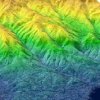
Orthorectified Radar Imagery (ORRI)
One of the most valuable products derived from the IfSAR data is the
orthorectified radar imagery (ORRI). The ORRI are black-and-white
(grayscale) 8- or 16-bit orthorectified radar imagery with a
pixel resolution ranging from 1.25 to 2.50 meters. The common tile size
is 10 x 10 kilometers. Some additional specifications are listed below.
Ground Sample
Distance |
Horizontal Accuracy
(meters) |
File Size (MB)
8-bit Data |
| 1.25 | ±1.25 | 128 |
| 2.50 | ±2.50 | 32 |
The common file format for ORRI products is GeoTIFF, with a Universal Transverse
Mercator (UTM) projection and 1984 World Geodetic System (WGS84)
ellipsoid datum. Companies may provide user-specified formats upon request.
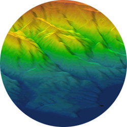
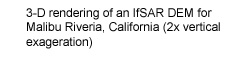
"Bald-Earth" or Digital Terrain Models (DTMs)
"Bald-earth" or digital terrain models (DTMs) are digital
elevation model (DEM) products that simulate the true earth-surface
elevations, minus ground features (i.e., trees, buildings, etc.).
DTMs can be produced by incorporating P-band
data in densely vegetated areas, and/or using interpolation algorithms
to filter out the presence of ground features from X-band
data.
IfSAR-Derived Products
Below is a list of common IfSAR-derived products that may be requested from private companies or derived by end-users.
- Digital Elevation Models (DEMs)
- Digital Terrain Models (DTMs) (bald-earth elevation data)
- Orthorectified Radar Imagery (ORRI)
- Topographic Line Maps (TLMs)
- Contours
- Shaded Relief
- Slope & Aspect
- Thematic Maps
Return to top
Applied Uses
Examples of how IfSAR data are being used:
Other Potential Uses:
- Hydrology Modeling
- Orthorectifying Imagery
- Flood Risk Assessment
- Land Use and Land Cover Mapping
- Earth Crust Deformation Monitoring
- Riparian Studies
- Forestry Mapping
- Emergency Response
- Transportation Mapping
- Telecommunication Planning
- Urban Development
Return to top
Specifications
Currently there are two commercial airborne IfSAR single-pass sensors
available in the United States. The companies Intermap
and EarthData
both provide X-band IfSAR data, with EarthData also providing P-band
data. The tables below outline the major specifications for both X-band
and P-band IfSAR data.
Topographic IfSAR X-band Specifications
| Altitude |
15,000 - 35,000 feet above ground level |
| Swath Width |
5 -10 kilometers wide (depending on altitude) |
Z Accuracy (Vertical) Root
Mean Square Error (RMSE) |
0.30 - 3 meters (depending on product type) |
| X, Y Accuracy (Horizontal) RMSE |
1 - 2.5 meters (depending on product type) |
| Resolution (Post Spacing) |
2.5, 5, or 10 meters (depending on product type) |
Topographic IFSAR P-band Specifications
| Altitude |
15,000 - 35,000 feet above ground level |
| Swath Width |
5 -10 kilometers wide (depending on altitude) |
| Z Accuracy (Vertical) RMSE |
1 - 5 meters (depending on product type) |
| X, Y Accuracy (Horizontal) RMSE |
2 - 4 meters (depending on product type) |
| Resolution (Post Spacing) |
2.5, 5, or 10 meters (depending on product type) |
Revisit Rate – Revisit rate is dependent upon flight scheduling. IfSAR can be flown at night, and can see through clouds, which can improve scheduling time.
Return to top
Data Ordering Details
![[sensor icon]](images/satelite.gif)
Data Acquisition |
There are currently two private companies in the United States that produce commercial IfSAR data, Intermap and EarthData. EarthData's GeoSar sensor provides X-band and P-band IfSAR data, and Intermap's Star3i sensor provides X-band data.
more info |
![[clock icon]](images/clock04.gif)
Timing |
There are a number of time constraints associated with IfSAR collection and delivery:
- Flight schedules can be delayed due to weather and environmental factors.
- Project areas may be large enough that multiple flights are needed.
- Post-processing of X- and P-band data can be time consuming.
- Producing additional deliverables can delay the delivery schedule.
- While generally considered "all-weather," because it can see through clouds and operate at night, turbulence at flight altitude will cause poor quality data.
|
![[dollar sign icon]](images/dollar.gif)
Cost |
A number of factors affect the final cost of IfSAR data: the size and location of the project area, the vertical and horizontal accuracy requirement for the data, licensing restrictions, and the amount of post-processing needed to produce certain product types, such as "bald-earth" or digital terrain models (DTMs). It is recommended that you contact either EarthData directly, or the Intermap pricing Web site, Global Terrain Pricing to request current costs. |
![[cd icon]](images/software.gif)
Data Formats/Software Needed |
The most common IfSAR digital elevation model (DEM) data format provided by private companies is 32-bit band interleaved by line (BIL) format. Companies may provide customer-specified formats upon request.
Software is required to import 32-bit BIL-formatted data and convert to any desired image formats (i.e., .tif, .img, GRID, etc.). The following are examples of commercially available software that can be used to accomplish these tasks:
Most image processing and geographic information system (GIS) software can be used to analyze or process IfSAR data, once the 32-bit BIL data have been converted to a desired image format (i.e., .tif, .img, GRID, etc.). |
![[globe icon]](images/E.gif)
Projections |
| Projection: |
UTM |
| Horizontal Datum: |
WGS84 |
| Vertical Datum: |
WGS84 |
| Geoid Model: |
EGM-96 (Earth Gravity Model) |
Companies may provide customer-specified projections and datums upon request. Contact companies for more information. |
![[license icon]](images/license.gif)
Licensing |
Licensing restrictions vary for each IfSAR data provider. To determine exact restrictions, please contact each company directly. The licensing options can have a large effect on cost and usability of the data. |
Return to top
Frequently Asked Questions
Data Acquisition
Can I download or request IfSAR data on-line?
Intermap data can be ordered, but not downloaded, on-line. Intermap
data requests can be made at the company's product store Web site, GLOBAL
Terrain. EarthData
must be contacted directly for any data requests.
The NOAA Coastal Services Center currently has IfSAR data of southern California available via the
IfSAR Data Viewer.
General Questions
What are X-band and P-band data?
X-band and P-band refer to the frequency of the radar(s) used
by an IfSAR system. Each radar frequency interacts differently with
the surface it targets. Higher frequencies (e.g., X-band) interact
with smaller features, like leaves and small branches, resulting in
elevation measurements more closely representing the vegetation canopy.
Lower frequencies (e.g., P-band) interact with larger features,
allowing penetration of the vegetation canopy, resulting in elevation
measurements more closely representing the bare earth. The drawback
of the P-band is that the longer wavelength reduces the accuracy of
the elevation measurements.
Is freeware available for using these data?
Currently, no freeware software is specifically designed for IfSAR data;
however, a number of freeware viewers will allow you to view image data
and perform simple tasks. Some of these viewers allow the user to view
32-bit BIL data and save as a common image format. It is recommended
that you contact the software companies for more details. The following
are some examples of freeware viewers:
What technical expertise is needed to use/analyze the data?
Some experience working with topographic and raster data may be needed to analyze and process IfSAR data.
What are the limitations of IfSAR data?
- IfSAR X-band has difficulty mapping earth surfaces with dense vegetation. The X-band registers first-return signals from ground
features. In the case of densely forested areas, the X-band receives return signals from the tree canopy, rather than the earth surface. P-band can penetrate dense vegetation with good results and provides an alternative solution for these harder to map areas.
- IfSAR has difficulty mapping certain areas where it cannot see the earth surface, such as the shadowed areas of mountains or buildings. This is a result of the angle of flight with respect to the target areas. These areas can result in voids in the DEM data, which are corrected, as best as possible, by interpolation modeling during the post-processing effort. It is possible to request from the IfSAR provider a GIS layer where these voids were corrected. To minimize potential voids, it is better to sample an area with multiple looks.
- There are certain materials (e.g., calm water) that reflect radar signals away from the transmitter causing null elevations.
- The military restricts the use of P-band frequencies around certain facilities and areas. This can impact the quality of IfSAR data.
How do clouds affect the data?
Clouds are typically not an issue in IfSAR collection.
What are the approximate file sizes for IfSAR elevation data?
Below are approximations of IfSAR 32-bit raster data file sizes.
| 10x10 Kilometer Tile Size |
|---|
| 5-meter resolution: | 28 MB |
|---|
| 10-meter resolution: | 7 MB |
|---|
Return to top
For more Information
Return to top