CIRES logo
SCIENCE
EDUCATION
NEWS & EVENTS
JOBS & OPPORTUNITIES
about the INSTITUTE

Now Featuring...

Daily Arctic sea ice extent for August 26, 2008 - orange line shows the 1979 to 2000 average extent for that day lidar schematic Ocean with rising temperature, affecting land warming

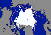
Arctic Sea Ice Now Second-Lowest On Record  >>>

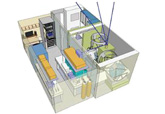
CIRES Pushes Lidar Technology Boundaries  >>>

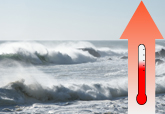
Ocean May Be Best Predictor Of Future Land Warming  >>>

Cryospheric and polar processes
Arctic climate
Ice sheets and glaciers
Snow cover & snow hydrology
Permafrost
Weather and climate dynamics
Atmosphere–ocean interactions
Tropical convection
Connecting climate & weather
El Niño
Environmental chemistry
Climate forcing
Air quality
Stratospheric ozone
Ecosystem science
Water quality
Regional & global disturbances
Land-atmosphere exchanges
Environmental observations,
modeling, & forecasting

Remote sensing, Global climate modeling
Carbon/greenhouse gas measurements
Geophysical data stewardship
Solid earth sciences
Geochemistry of mountains
Crustal deformation & mantle dynamics
Landscape evolution & climate
Gravity from space
  
CIRES is cooperative institute of CU-Boulder and NOAA.
NOAA Disclaimer | CU- Boulder Privacy Statement | CIRES Contacts | INsideCIRES
page last changed: Monday, 15-Sep-2008 14:33:05 MDT