The Journey to Restore America's Everglades - Recover Home Page
National Park Service Home Page South Florida Water Management District Home Page U.S. Army Corps of Engineers Home Page U.S. Geological Survey Home Page
Everglades Depth Estimation Network (EDEN) for Support of Biological and Ecological Assessments


Transect Plotter

screenshot of EDEN transect utility

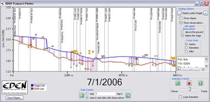
EDEN Transect Plotter is a program for plotting daily water level surfaces and ground elevation profiles for user-specified transects across the Everglades. The water surface can be animated over a user-specified time period and the water surface slope is calculated and displayed along the transect for user-specified distances.

Location of nearby water level gaging stations can be indicated on the transect plot. The location of the gage in meters perpendicular to the transect line provides users with information about data that may have been used in development of the transect plot. The daily median output files must be reviewed to determine if gage data were available for the period of interest.

Additionally, user-provided observations of water level and water depth can be plotted on the transect for comparison with the EDEN water surface. The user-specified distance perpendicular to the transect identifies a selection criteria for observations that are plotted on the transect plot.

All water level and ground elevation data are output in units of North American Vertical Datum of 1988 (NAVD88).

Note: the latest version of the Transect Plotter was modified to provide for the ability to select an output path for the slope output file. Please see the User's Guide (below) for more information.

CERPZone users, please see information below.

Installation

You will need the following files:

Required for execution of the program:

(Note: if you previously installed other EDENapp tools, then you may have some or all of these items already installed)

  1. EDEN Transect Plotter.exe (.zip, 229 KB, currently at v. 1.2 - updated July 24, 2008)
    • Executable file can be copied to any location on your computer.
  2. List of EDEN stations and locations
    • Used to incorporate nearby gage locations on the transect plot
    • Filename must be stations.txt
    • Must be copied to folder containing the Transect Plotter.exe file
    • Included as part of the EDENTransectPlotter.zip file download
  3. netCDF dlls (.zip, 176 KB)
    1. Extract all the files in netcdf-3.6.1-win32.zip and copy them to c:\windows\system32
  4. Microsoft .Net version 2.0 (download from Microsoft's website)
    • Note: this may already be installed on your machine. Go to: Start > Control Panel > Add or Remove Programs. If Microsoft .Net Framework is installed, it will appear in this list

Required User Input Files:

  1. EDEN DEM file for ground elevation (.zip, 170 KB)
    • Must be in netCDF file format (.nc)
    • Please note: This file is a modification of the EDEN DEM released in October of 2007 (i.e., eden_em_oct07) in which the elevation values have been converted from meters (m) to centimeters (cm) for use by EDEN applications software. This file is intended specifically for use in the EDEN applications software.
    • Metadata is also available for this DEM and has been included in the EDEN DEM zip file.
  2. EDEN daily water level surfaces (must be in NetCDF file format (.nc))
  3. Transect points file (see User's Guide below for more information)

User's Guide (pdf, 603 KB - updated July 24, 2008)


Notes:

  • EDEN Transect Plotter can only run on a Windows machine
  • The netCDF dll is required to use xyLocator. Extract all the files in netcdf-3.6.1-win32.zip and copy them to c:\windows\system32
We're looking for feedback! Please contact us.


Running EDENapps from CERPZone:
The EDENapps tools can be run from CERPZone by users who are not able or do not wish to download the EDENapps tools to their computers. CERPZone allows users to run the tools directly from the Citrix server.

To run the tools from CERPZone, users must obtain a CERPZone username and password at http://www.evergladesplan.org/AccessRequest/

To go to the EDENapps tools on CERPZone, got to https://www.cerpzone.org/help/eden.aspx for instructions to access the tools through the Citrix server. If you have any questions regarding EDEN Tools on Cerpzone, please contact cerpgishelp@evergladesplan.org.

Note: New CERPZone users will need to contact the CERP GIS Team (cerpgishelp@evergladesplan.org) to be added to the EDEN application user's pool.

Home
Data
Water Levels (Gage)
Ground Elevation (DEM)
Water Surfaces
Meteorologic
EDENapps
Introduction
DataViewer
xyLocator
Transect Plotter
Depth&DaysSinceDry
GridtoNetCDF
NetCDFtoGrid
Information
Learn About EDEN
Publications
Newsletter
EDEN Personnel
Contacts
Photo of a flower

Technical support for this Web site is provided by the U.S. Geological Survey
This page is: http://sofia.usgs.gov/eden/edenapps/transectplotter.php
Comments and suggestions? Contact: Heather Henkel - Webmaster
Last updated: July 25, 2008 04:29 PM(HSH)