
 Feeds & Data
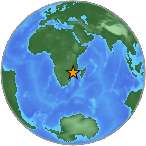
Magnitude 7.0 - MOZAMBIQUE
2006 February 22 22:19:07 UTC
Earthquake Details
| Magnitude | 7.0 |
|---|---|
| Date-Time |
|
| Location | 21.259°S, 33.480°E |
| Depth | 11 km (6.8 miles) set by location program |
| Region | MOZAMBIQUE |
| Distances | 215 km (135 miles) SW of Beira, Mozambique 235 km (145 miles) S of Chimoio, Mozambique 530 km (330 miles) N of MAPUTO, Mozambique 990 km (610 miles) NNE of Durban, South Africa |
| Location Uncertainty | horizontal +/- 8.7 km (5.4 miles); depth fixed by location program |
| Parameters | NST=243, Nph=243, Dmin=866.2 km, Rmss=1.31 sec, Gp= 22°, M-type=teleseismic moment magnitude (Mw), Version=S |
| Source |
|
| Event ID | usjlca |
- This event has been reviewed by a seismologist.
- Did you feel it? Report shaking and damage at your location. You can also view a map displaying accumulated data from your report and others.
Earthquake Summary

Felt Reports
One person killed at Espungabera, one killed at Machaze and 2 killed at Beira. Twenty-seven people injured and at least 160 buildings damaged in the Espungabera-Beira-Chimoio area. Power outages occurred at Maputo. Felt (V) at Beira, Inhambane and Maputo; (IV) at Matola. Felt (IV) at Harare and Mutare, Zimbabwe. Also felt (IV) at Louis Trichardt and Phalaborwa; (III) at Durban and Middelburg; (II) at Johannesburg and Pretoria, South Africa. Felt throughout Mozambique and eastern Zimbabwe. Felt in Swaziland and at Lobatse, Botswana and Lusaka, Zambia.
Tectonic Summary
The earthquake occurred near the southern end of the East African rift system. The East African rift system is a diffuse zone of crustal extension that passes through eastern Africa from Djibouti and Eritrea on the north to Malawi and Mozambique on the south and that constitutes the boundary between the Africa plate on the west and the Somalia plate on the east. At the earthquake's latitude, the Africa and Somalia plates are spreading apart at a rate of several millimeters per year. The largest earthquake to have occurred in the rift system since 1900 had a magnitude of about 7.6. Most earthquakes within the East African rift system occur as the result of either normal faulting or strike-slip faulting.
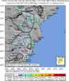
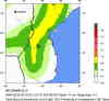
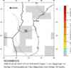
Earthquake Maps


Scientific & Technical Information

- Preliminary Earthquake Report
- U.S. Geological Survey, National Earthquake Information Center:
World Data Center for Seismology, Denver
