|
projects > understanding and predicting global climate change impacts on the vegetation and fauna of mangrove forested wetlands in florida > photo gallery
Photo Gallery
The following photographs were taken on January 3, 2002, during a helicopter flight over portions of Everglades National Park and elsewhere in south Florida by USGS Director, Dr. Chip Groat, Research Ecologist, Dr. Tom J. Smith, and Miami Sub-District Chief, Maggie Irizarry. The flight was made to provide an introduction to the Director and Chief on a number of USGS, and collaborators, research projects in Everglades National Park and how they relate to the hydrologic restoration currently being undertaken in the Greater Everglades.
These projects include:
- Understanding and Predicting Global Climate Change Impacts on the Vegetation and Fauna of mangrove Forested Ecosystems in Florida
- Hydrologic Variation and Ecological Processes in the mangrove Forests of south Florida: Response to Restoration
- Vegetation Dynamics in land-margin Ecosystems
- Interrelation of Everglades Hydrology and Florida Bay Dynamics to Ecosystem Processes in south Florida
- Tides and Inflows to the Mangroves of the Everglades (TIME): Hydrologic Model Development
- Land Use Change and Global Climate Change Impacts on the Regional Climate of south Florida and the Everglades
- Florida Coastal Everglades Long-Term Ecological Research Program
The above list is by no means exhaustive nor does it attempt to be all inclusive of each USGS project in the south Florida ecosystem.
| Navigate through the flight path by clicking on a letter seen in the map below. When you arrive at your destination, click on thumbnails to view full-size images in new window. |
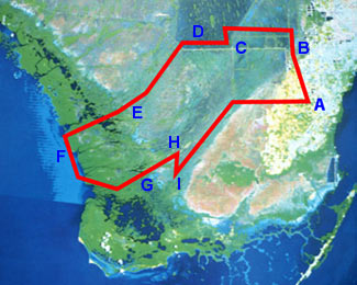
| A |
B |
C |
D |
E |
F |
G |
H |
I |
|
 |
 |
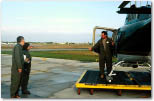 |
| USGS Director Chip Groat and Miami Sub-District Chief Maggie Irizarry check out the helicopter. |
Rich Kearns, the pilot, with Chip and Maggie. |
Pilot briefing the passengers. |
|
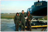
(left and right) Maggie, Chip and USGS Research Ecologist Tom Smith, stand by the helicopter before take-off. |

|
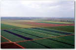 |
Along flight path segment, AB. An agricultural field a short distance east of the Everglades National Park boundary. Note the irrigation equipment in foreground. Agricultural is just one of several water users in south Florida and also a major historical land-use change. |
| Point B |
 |
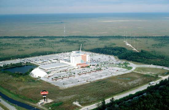
The Miccosukee Indian Gaming Hall at the intersection of US41 (Tamiami Trail) and Krome Avenue near the northeast corner of ENP. The "Trail" runs east-west across south Florida. Water Conservation Area 3B (WCA3B) is in the background. The Water Conservation Areas are designed to alleviate flooding and provide for urban water supply. |
| Point C |
 |
View looking north of Levees 67A and 67C. These two levees and associated canals run diagonally across Water Conservation Area 3 (WCA3) dividing it in two parts 3A (west) and 3B (east). The restoration plan calls for partial removal of the levees to restore sheetflow between WCA 3A & 3B and to increase water flowing into northeast Shark River Slough in Everglades National Park (ENP). |

|
View to the south of the L67 extension canal and levee. This canal runs from WCA3 south along the old eastern boundary of ENP. It cut Shark River Slough into two, the Northeast and Northwest sections. Restoration plans call for the complete removal of the levee and filling the canal to reconnect Northeast Shark River Slough to the rest of Shark Slough. |
(looking north to south) |
(looking west to east) |

(looking west to east) |
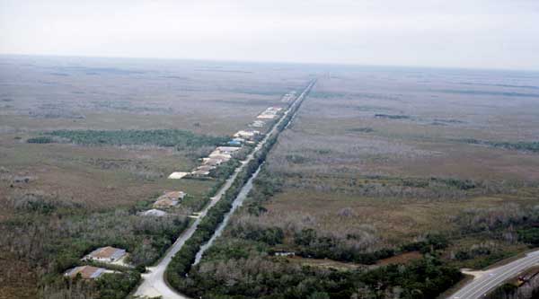
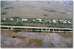
| Water Conservation Area 3 (WCA3) (foreground and left) is holding a large amount of water, whereas Everglades National Park (ENP) to the south, across US41 and the row of houses, is very dry. The highway and houses form a hydrologic barrier to naturally north to south sheetflow. Restoration plans call for elevating the highway and creating flow-ways to restore the surface water hydrology. |
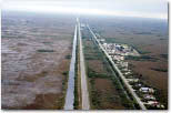
| (right) View looking from east to west along the Loop Road. ENP lies to the south (left) and Big Cypress National Preserve to the north (right). Surface water movement from WCA3, through the Loop and into ENP is a concern for the restoration. |

|
 |
 |
| Two pictures of an evapo-transpiration measurement site run by Ed German, WRD. Evapo-transpiration (ET) from the various wetland vegetation communities is an unknown in the water budget for the Everglades. This ET site is located near a study site of the south Florida Global Climate Change (GCC) project. |
| Close-up shot of site LO1. The instrument platform is visible in the center left. It holds data loggers and instrumentation to monitor surface water and groundwater stage and conductivity. The three wooden platforms in the center right are associated with Sediment Elevation Tables (SETs). Two permanent vegetation monitoring plots are adjacent to each SET. |
 |
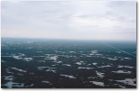
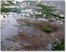
| The freshwater wetlands of the Everglades (upper and left) grade into the brackish mangrove forested wetlands (right) downstream as one nears the Gulf of Mexico. Understanding how and why the position of this ecotone has changed over time is a central question of the GCC research as is predicting its movement under the current restoration plan. Using the pattern of movement in this ecotone over the future has been proposed as one Performance Measure for gauging restoration success. |
 |
 |
Along flight path segment, EF. The GCC study sites are arranged in transects from upstream, freshwater marsh sites, to downstream, marine locations. Site Lostmans 2 (LO2) is a mid-transect site located in a brackish needlerush marsh that is surrounded by mangrove forests. The hydrology monitoring platform is visible in the center of the photo. Boardwalks lead to the three SET locations and associated vegetation plots. The hydrologic data being gathered by the GCC project is being used in the TIME hydrological models. |
 |
Along flight path segment, EF. Resource managers at Everglades National Park are concerned about preserving coastal, marine prairie habitats. Controlled burns are one aspect of management. The GCC program routinely samples along transects which cross from mangrove forest (upper left) into coastal marsh (center) to study the affects of fire. |
 |
Patches of marsh vegetation interspersed among expansive mangrove forested wetlands along the Shark River. |
 |
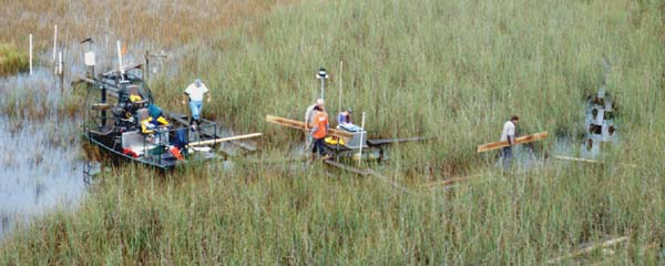
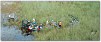
(left and right) Field team of biologists, hydrologist, geologist and International Student Volunteer conducting work at site Shark River 1 (SH1). This Global Climate Change (GCC) research site is accessed by airboat and helicopter. The boardwalk connects sampling stations for: 1) ground and surface water stage and conductivity (silver box in center); 2) sediment elevation and vegetation monitoring (platforms in lower left and lower center); and, 3) marsh water column temperature and flow velocity (platform and white structure center rear). |
 |
 |
Higher altitude photograph of SH1. Visible in the background is another Evapo-transpiration measurement platform. |
 |
 |
 |
 |
 |
 |
| Six photographs from varying altitudes and angles of the field crew at SH1. |
| Point I |
 |
Hydrologists from the WRD National Research Program in Reston are examining the affect of marsh fires on the flow structure of the marsh water column and how vegetation re-growth alters flow. This photo shows a sawgrass marsh that has not burned in the recent past, thus having relatively dense vegetation (right). A recently burned portion of sawgrass is visible to the left and top portion of the picture, with a clear boundary running between the burned and unburned marshes. The flow monitoring station is in the center of the photo. |
To top of page
| For more information or if you have any questions, contact: |
Thomas J. Smith III, Ph.D.
Research Ecologist
U.S. Geological Survey
Florida Caribbean Science Center
c/o Center for Coastal & Regional Marine Studies
600 Fourth Street, South
St. Petersburg, Florida 33701
Voice: 727-803-8747 ext 3130
FAX: 727-803-2030
Email: Tom_J_Smith@usgs.gov |
|