|

DCNet/URBANet
Data
Background
There were no chemical, biological agent, or radioactivity
releases involved in the attack of September 11. Nevertheless, the
atmospheric dispersion community was immediately alerted. There
was a recognized risk of a new attack, using different methods for
invoking terror. The risk continues. Washington, DC, is seen as
one of the more likely targets.
There are many possible scenarios that need to be considered.
Also, it is appreciated that an actual event, should it ever occur,
will likely differ from any of the scenarios that have been considered.
We need to prepare for any such eventualities, with the fervent
hope that our preparations will never be tested. At the same time,
we need to make sure that we are ready to take the necessary steps
to protect people, if the unthinkable ever happens. To these ends,
we need modeling systems that can be used to describe the dispersion
of the substances through the air, in much the same way as weather
forecasts are developed and delivered. In reality there is a lot
of similarity between weather forecasting and the prediction of
dispersion. It is the wind fields that determine where released
materials will drift, and it is atmospheric turbulence that controls
the rate at which dilution occurs.
The nation has many computer systems developed to predict
the dispersion of hazardous materials released into the atmosphere.
The capabilities are widespread across the federal agencies, state
and local authorities, academia, and the private sector. Every one
of these systems has some special quality that makes it unique.
The trick now facing the atmospheric dispersion community is to
determine which subset of the many dispersion systems is best suited
to the challenges now facing us. There is a Federal Coordinator for Meteorology, under
whose auspices the meteorological activities of the various federal
agencies are coordinated. Immediately following 11 September 2001,
the Federal Coordinator initiated a process to help sort out which
of the many available models would be most applicable in the event
of an attack using chemical, biological or radioactive releases
into the air. The Office of the Federal Coordinator recently summarized
its findings in a report that identifies 29 modeling systems running
24 x 7 within the federal system. Of these, nine systems are used
nationwide. These are roughly equally split between the military
and civilian agencies.
Sorting out which might be the best proved impossible,
because each has special strengths to address the particular issues
for which it was initially intended. The recommendation was made,
therefore, that there is no existing “best capability”
suitable for widespread application. Nor is it likely that any such
generalized model will be developed in the near future. Instead,
we need to learn how to access the suite of capabilities now in
use, and to select from it the capabilities best suited to situations
that my arise.
There is a practical reality that complicates the situation
substantially. Most available modeling systems have been developed
on the basis of understanding generated in field studies over grass
or desert, completely in the absence of buildings or other large
surface structures. The application of current concern centers on
cities and urban areas, where the buildings will cause changes in
wind fields that are not yet well understood. There are research
programs presently under way to investigate the dispersion characteristics
of urban areas. Recent field studies in Salt Lake City, for example,
have yielded a lot of new information. However, we do not yet know
how to apply the results applicable for some specific urban area
to another, with confidence. Consequently, there is a strong need
to obtain relevant data, based on measurements in the situations
of actual importance.
This is the basis for the design of DCNet –
a program to provide Washington, D.C., with the best possible basis
for dispersion computation, as is needed for both planning and possible
response.
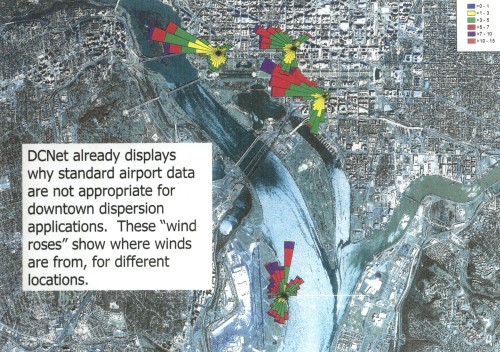
The problem we face is complex. The winds within a city
sometimes bear little resemblance to those of the surrounding countryside.
The weather forecasting community tends to rely on wind information
collected at airports, typically well outside the urban areas that
are now of main interest. To assume that the wind fields
experienced at airports are the same as those appropriate for downtown
areas would clearly be inappropriate. The presence of buildings
and the “street canyons” separating them causes
behaviors that are almost random, exceedingly difficult to predict
or even describe. However the flow above the “urban canopy”
is far more describable in terms of larger scale meteorology. It
is convenient to think in terms of two regimes – the street
canyon flows beneath the urban canopy and the “skimming flow”
above it. Washington, D.C., presents an excellent testbed for studies, because the urban canopy is well defined
by the height constraint on the buildings. New York City, for example,
presents an opposite extreme. In New York City, the buildings are
not only very high, but their height is quite variable.
There are thus two major reasons to focus attention
on the Washington, D.C., metropolitan area. First, the attention
is needed because, like it or not, we are a potential target. Second,
the urban landscape lends itself to the application of new science,
so that greatly improved capabilities are feasible. But there is
a third reason that makes Washington, D.C., so attractive. In 1983,
a year-long study was conducted there, largely replicating the sort
of situation that some people fear we might be confronting. In the
1983 study, minute amounts of harmless but very easily detected
trace gases were released from a number of locations around and
inside the beltway. (One of the gases used was sulfur hexafluoride,
commonly used as an insulator in high voltage transformers. Several
other trace gases were used, all variants on the fluorocarbons used
in refrigeration.) This METRopolitan Experiment (“METREX”) has provided a baseline
of understanding not present anywhere else. METREX was a NOAA program,
specifically designed to test how well dispersion models perform
in an urban area like the District of Columbia. The news was not
good – the predictions were very poor. But there was some
good news as well – the models appear to describe the statistics
of the behavior quite well. That is, they fail to reproduce the
fine details of what is going on, but they succeed in describing
the probability that some particular range in exposures will be
encountered. Based on this experience, the current program addresses
the statistical description of urban dispersion directly. We are
not that interested in the concentrations that might be found at
a particular point in time, at a specific location. We are very
interested in the likelihood that people will be harmed.
DCNet (and “UrbaNet”)
With the experience of METREX behind them and the recognition
that Washington, D.C., is now an attractive target, NOAA scientists
have deployed an array of meteorological stations in the downtown
area.
 DCNet grew out of a recognition by dispersion
scientists within the Air Resources Laboratory (ARL) of NOAA that
society now faces a critical question. How do we forecast dispersion
in urban areas and in cities when the meteorological data used by
the weather forecasting community are from locations outside the
area of probable concern. There are no
models yet reliable enough to extend the forecasts of wind direction
and speed into the downtown regions of current concern. Moreover,
dispersion computations rely on assumptions about diffusion rates
that are based on experience in areas that are quite different from
cities. After discussion among scientists frtom other agencies, it was decided that a Washington,
D.C., testbed should be advocated. A proposal
was prepared and was formally endorsed by NOAA as a part of the
FY-04 funding cycle. The proposal received support from NOAA and
from other agencies, however at the Department of Commerce level
it was decided that support for the program would best come from
the new Department of Homeland Security. The proposal was then submitted
for Homeland Security attention through the Office of the Federal
Coordinator for Meteorology. This Office is the formal organization
within the federal system for coordinating activities related to
meteorology, among the agencies.
DCNet grew out of a recognition by dispersion
scientists within the Air Resources Laboratory (ARL) of NOAA that
society now faces a critical question. How do we forecast dispersion
in urban areas and in cities when the meteorological data used by
the weather forecasting community are from locations outside the
area of probable concern. There are no
models yet reliable enough to extend the forecasts of wind direction
and speed into the downtown regions of current concern. Moreover,
dispersion computations rely on assumptions about diffusion rates
that are based on experience in areas that are quite different from
cities. After discussion among scientists frtom other agencies, it was decided that a Washington,
D.C., testbed should be advocated. A proposal
was prepared and was formally endorsed by NOAA as a part of the
FY-04 funding cycle. The proposal received support from NOAA and
from other agencies, however at the Department of Commerce level
it was decided that support for the program would best come from
the new Department of Homeland Security. The proposal was then submitted
for Homeland Security attention through the Office of the Federal
Coordinator for Meteorology. This Office is the formal organization
within the federal system for coordinating activities related to
meteorology, among the agencies.
The DCNet stations are more than standard meteorological
observing stations. They report not only the wind speed and direction,
but also the intensity of the turbulence. Sonic anemometry is used.
Sonic anemometers measure the speed of sound along three axis, and
derive from these data the wind speed along these axis with great
accuracy and frequency. A measurement frequency of ten times per
second is typical. The instruments are mounted on 10 m towers, mostly
on the tops of buildings where data on the skimming flow can be
obtained. One of the most visible locations can been
seen from Constitution Avenue, by the Vietnam Memorial. The tower
can be seen on the roof of the National Academy of Sciences (see
photo above), where the Einstein Memorial is located. Other towers
are distributed across the downtown area – on the buildings
of the Departments of Energy, Commerce and Agriculture, for example.
The data are analyzed by computers on each tower and are transmitted
to a central analysis location every fifteen minutes.
For obvious reasons, the Washington downtown system
is referred to as “DCNet.” It is proposed that
the operation should be extended to cover the greater DC Capital
Region (extending as far as Baltimore in Maryland), in which case
the broader descriptor “UrbaNet” is being used.
The system is a demonstration of capabilities that now
exist and are ready for deployment. A trial system is now running,
which enables a user to identify a source location with the click
of a mouse, and define the downwind area of potential high risk
using observations from the DCNet system. There is no long wait
involved. Results can be generated almost instantaneously. In practice,
this new generation of dispersion system relies on access to the
best available weather forecast data as well as the information
from dedicated arrays of sensors like DCNet. There are, of course,
many other sources of meteorological information that could be accessed
(highway sensors operated by Departments of Transportation, for
example). A challenge to the research community is to sort out how
best to make use of data from such sources.
 It has already been emphasized that the main goal of DCNet is to
refine our understanding of how hazardous trace gases and particles
are dispersed across the kind of area where people work and live.
To this end, the operational systems that are now being improved
are viewed not as being final developments, but as continuously
evolving capabilities with changes being made immediately as improved
understanding warrants. A major concern is that an incorrect forecast
could do more harm than good, and the need to demonstrate the accuracy
of the forecasts is always emphasized. A new round of tracer studies
is anticipated.
It has already been emphasized that the main goal of DCNet is to
refine our understanding of how hazardous trace gases and particles
are dispersed across the kind of area where people work and live.
To this end, the operational systems that are now being improved
are viewed not as being final developments, but as continuously
evolving capabilities with changes being made immediately as improved
understanding warrants. A major concern is that an incorrect forecast
could do more harm than good, and the need to demonstrate the accuracy
of the forecasts is always emphasized. A new round of tracer studies
is anticipated.
The Washington exercise is seen as a prototype of what
could eventually be a nationwide program. There is testing and development
ahead, well before any decisions about wider deployment are made.
In the meantime, the system now in place offers this area an unparalleled
capability to plan for possible attacks, and to respond if one were
to occur.
|
|