« Go Back
About GISCorps
GISCorps was founded in October 2003 as a program of Urban and Regional information Systems Association. GISCorps coordinates short term, volunteer based Geographic Information System (GIS) services to underserved communities worldwide. GISCorps volunteers' services support humanitarian relief, environmental analysis, economic development, community planning and sustainable development, local capacity enhancement, and health and education.
GISCorps does not sponsor projects directly. GISCorps will refer volunteers to agencies and vice versa, but volunteers will deal directly with the host agencies. Neither URISA nor the GISCorps will be responsible for food, lodging, living expenses, and insurance of its volunteers. These expenses will be defrayed either by the individual, her/his institution, the partner organizations, or by the host community, on a project-by-project basis.
More detailed information regarding GISCorps' model is located at: http://www.giscorps.org/GC_policies.php.
International Voluntary Service Activities
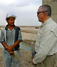
GISCorps currently has over 900 American volunteers and they have expertise in all and every geo spatial field.
In just over three years, GISCorps has implemented 20 missions that have engaged 65 volunteers. These remote and non-remote missions have taken place in various countries such as: Peru, Indonesia, India, Afghanistan, Dominican Republic, Guatemala, Haiti, Honduras, Egypt, Mali, Hungary, Marshall Islands, Kenya, Armenia, Namibia, and the United States. More details about our missions can be found at: http://www.giscorps.org/projects.php.
| Volunteer for Prosperity Opportunities |
| Number of Opportunities |
-- |
|
| Geographic Regions |
Project Dependent |
|
| Health & Prosperity Sectors |
Tsunami Relief; Health; Capacity Building; Information & Communication Technology; Natural Resources Management |
|
| Types of Opportunities |
Technical |
|
| Average Duration of Projects |
2 weeks |
|
| Volunteer Profile Summary |
| GISCorps volunteers must have expertise in a variety of geospatial technology related fields including GIS database design, needs assessment, environmental analysis, spatial modeling, web based interactive mapping applications, GIS training, GPS data collection, technical writing, and etc. |
|
|