|
About the 2002 North Pole
Web Cam Images
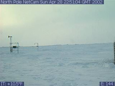
NOAA/PMEL's North Pole Web Cam was first deployed
on April 28, 2002. In order to conserve power and reduce satellite
transmission time, the web cam was been programmed to send only
4 images per day from the North Pole. The camera was dynamically
programmable, so PMEL could change the configuration
(camera angle, zoom, frequency of photos, etc.) at any time.
The images from the camera tracked the North Pole snow cover,
weather conditions and the status of PMEL's North Pole instrumentation,
which includes meteorological and ice sensors (seen in the camera
images).
Location: The
web cam and instruments
you see in the photos were deployed on an ice floe at the North
Pole. On the horizon, you see the pressure ridge at the edge of
the ice flow. Because the ice floes are drifting with the wind,
the location (latitude and longitude) of the camera changes every
day. When the image at the top of this page was taken, the ice floe
was several miles from the North Pole. Click to see the present
location of the North Pole camera and instrumentation.
Temperature: The temperature you see
in the left corner of the picture is correct. It is the temperature
of the camera, and may be warmer than the surrounding air temperature
(think about how your car heats up on a sunny day). Because it is
spring, the temperatures are warmer than they are in the middle
of winter, when the temperatures are near -30 deg C. Also the ocean
water below the ice floes is near the freezing point for salt water
(-1.7 deg C), so this helps keep the temperatures higher than they
would be on land. Click to see the temperature and other realtime
data from the North Pole instruments.
Time/date of photographs: The photograph
was taken at the date and time shown at the top of the image. The
date/time is given as Greenwich Mean Time (GMT), which is the time
at the "Greenwich meridian", a north-south longitude line
passing through Greenwich, England. (GMT
is also called UTC, or Universal Coordinated Time). To convert the GMT/UTC to the U.S.
East Coast time zone, subtract 4 hours. To convert the GMT/UTC to
the US West Coast or Pacific time zone, subtract 7 hours from the
GMT/UTC time. Ignore the number shown in the lower right corner
of the image, which is an internal camera system number. Data from the instruments: Realtime data
from the instruments you
see in the photographs is available on the North
Pole Weather Data page and from the North
Pole Observatory web site mentioned in the acknowledgments.
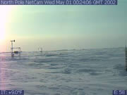 Colors in the photographs: One point to
notice is that the midnight sun is already above the horizon 24
hours a day at this location for the first of May. The colors you
see in the photographs are correct. For example the rosy colors
in the image to the right are normal twilight colors at the North
Pole.
Colors in the photographs: One point to
notice is that the midnight sun is already above the horizon 24
hours a day at this location for the first of May. The colors you
see in the photographs are correct. For example the rosy colors
in the image to the right are normal twilight colors at the North
Pole.
Arctic links:
More Information :
|