
Northern Rocky Mountain Science Center (NOROCK)
Home | About Us | Science | Product Library | News & Events | Staff | Students | Partners | Contact Us
Northern Rocky Mountain Science Center (NOROCK)
Home | About Us | Science | Product Library | News & Events | Staff | Students | Partners | Contact Us

Research Areas
Glacier Research
Snow and Avalanche Research
Mountain Ecosystems
Landscape Change Photography
Western Mountain Initiative
Product Library
Publications
Presentations
Glacier Recession Animation
Flattop SNOTEL Graphs
Repeat Photo Posters
Info Sheets
Photo Galleries
Repeat Photography
Panoramic Photography
Field Research
CCME Staff
Dan Fagre
Lisa McKeon
Blase Reardon
Lindsey Johnson
Erich Peitzsch
Chris Miller
Greg Pederson
Contact CCME
CCME
Glacier National Park
West Galcier, MT 59936
NOTE: Proper credit for any of the photographs should include the photographer and the source (eg. T.J. Hileman, courtesy of Glacier National Park Archives). View the paired images to see examples of proper crediting for each photo. For more information see the section Use Guidelines and Proper Crediting.
NOTE: Please complete the brief Repeat Photo Usage Form if you download photos from this site.
The 1913 image of Sperry Glacier shows the thickness of the glacial ice that once covered the Sperry basin. Now, at approximately 1/3 of it's maximum area, Sperry Glacier continues to recede at a rapid rate. It is one of the glaciers that USGS scientists are monitoring as a benchmark glacier.
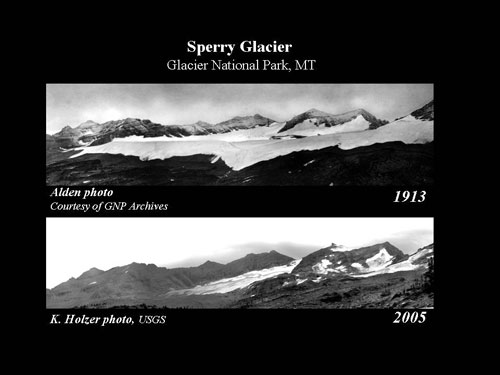
PAIRED 1913 photo by W. C. Alden, Glacier National Park Archives - 2005 photo by Karen Holzer, USGS |
|
| 960x720 pixels (55 kb) format jpeg Sperry13_05.jpg (small file) |  |
| 960x720 pixels (468 kb) format tif Sperry13_05.tif (small file) | |
| powerpoint format (6.61 mb) Sperry13_05.ppt (very large file) | |
HIGH RESOLUTION 1913 photo by W. C. Alden, Glacier National Park Archives
|
|
| 2233x644 pixels (718 kb) format jpeg Spr913_Alden.jpg (smaller file) |  |
| 2233x644 pixels (1.37 mb) format tif Spr913_Alden.tif (larger file) | |
HIGH RESOLUTION 2005 photo by Karen Holzer, USGS
|
|
| 2220x457 pixels (456 kb) format jpeg Spr005_Holzer.jpg (small file) |
 |
| 2220x457 pixels (999 kb) format tif Spr005_Holzer.tif (small file) |
|
