
 Feeds & Data
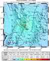
Magnitude 5.7 - COLOMBIA
2008 September 13 09:32:00 UTC
Earthquake Details
| Magnitude | 5.7 |
|---|---|
| Date-Time |
|
| Location | 4.828°N, 75.407°W |
| Depth | 118.4 km (73.6 miles) |
| Region | COLOMBIA |
| Distances | 30 km (20 miles) SSE of Manizales, Colombia 30 km (20 miles) E of Pereira, Colombia 45 km (30 miles) NE of Armenia, Colombia 150 km (90 miles) W of BOGOTA, Colombia |
| Location Uncertainty | horizontal +/- 8.1 km (5.0 miles); depth +/- 10.8 km (6.7 miles) |
| Parameters | NST=100, Nph=100, Dmin=610 km, Rmss=1.07 sec, Gp= 54°, M-type=regional moment magnitude (Mw), Version=7 |
| Source |
|
| Event ID | us2008wxay |
- This event has been reviewed by a seismologist.
- Did you feel it? Report shaking and damage at your location. You can also view a map displaying accumulated data from your report and others.


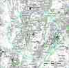
Earthquake Maps


Scientific & Technical Information

- Preliminary Earthquake Report
- U.S. Geological Survey, National Earthquake Information Center:
World Data Center for Seismology, Denver
