
 Feeds & Data
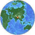
Magnitude 5.2 - WESTERN XIZANG
2008 September 10 01:28:07 UTC
Earthquake Details
| Magnitude | 5.2 |
|---|---|
| Date-Time |
|
| Location | 30.863°N, 83.356°E |
| Depth | 10 km (6.2 miles) set by location program |
| Region | WESTERN XIZANG |
| Distances | 210 km (130 miles) NNE of Jumla, Nepal 295 km (185 miles) NNW of Pokhara, Nepal 355 km (220 miles) NNE of Nepalganj, Nepal 400 km (250 miles) NNW of KATHMANDU, Nepal |
| Location Uncertainty | horizontal +/- 8.5 km (5.3 miles); depth fixed by location program |
| Parameters | NST= 55, Nph= 55, Dmin=761.4 km, Rmss=0.94 sec, Gp= 54°, M-type=body magnitude (Mb), Version=Q |
| Source |
|
| Event ID | us2008wuag |
- This event has been reviewed by a seismologist.
- Did you feel it? Report shaking and damage at your location. You can also view a map displaying accumulated data from your report and others.
Earthquake Maps
Earthquake Location
Location Maps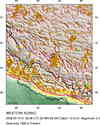
Historical Seismicity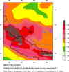
Seismic Hazard Map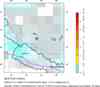
EQ Density Map
Google Map
Google Earth KML
(Requires Google Earth)- Did you feel it? Report shaking and damage at your location. You can also view a map displaying accumulated data from your report and others.
Scientific & Technical Information
 Historic Moment Tensor Solutions
- Preliminary Earthquake Report
- U.S. Geological Survey, National Earthquake Information Center:
World Data Center for Seismology, Denver
