
 Feeds & Data
Magnitude 5.3 - TAIWAN REGION
2008 September 09 07:43:13 UTC
Earthquake Details
| Magnitude | 5.3 |
|---|---|
| Date-Time |
|
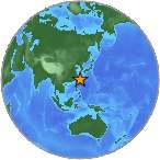
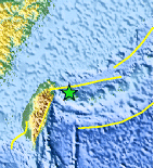
| Location | 24.633°N, 122.605°E |
| Depth | 99.9 km (62.1 miles) |
| Region | TAIWAN REGION |
| Distances | 75 km (50 miles) E of Su-ao, Taiwan 120 km (75 miles) ESE of T'AI-PEI, Taiwan 125 km (80 miles) NE of Hua-lien, Taiwan 165 km (100 miles) W of Ishigaki-jima, Ryukyu Islands, Japan |
| Location Uncertainty | horizontal +/- 5.2 km (3.2 miles); depth +/- 4.5 km (2.8 miles) |
| Parameters | NST=129, Nph=129, Dmin=114.6 km, Rmss=0.8 sec, Gp= 47°, M-type=body magnitude (Mb), Version=S |
| Source |
|
| Event ID | us2008wtaw |
- This event has been reviewed by a seismologist.
- Did you feel it? Report shaking and damage at your location. You can also view a map displaying accumulated data from your report and others.
Earthquake Summary
Felt Reports
Recorded (4 TAP) in I-lan; (3 TAP) in Hua-lien; (2 TAP) in Chang-hua, Miao-li, Nan-t'ou, T'ai-chung, T'ai-pei, T'ai-tung, T'ao-yuan and Yun-lin; (1 TAP) in Chia-i, Kao-hsiung and T'ai-nan.
Earthquake Maps
Earthquake Location
Location Maps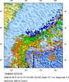
Historical Seismicity
Seismic Hazard Map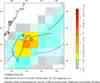
EQ Density Map
Google Map
Google Earth KML
(Requires Google Earth)- Did you feel it? Report shaking and damage at your location. You can also view a map displaying accumulated data from your report and others.
Scientific & Technical Information
 Historic Moment Tensor Solutions
- Preliminary Earthquake Report
- U.S. Geological Survey, National Earthquake Information Center:
World Data Center for Seismology, Denver
