Remote Sensing: Observing the Earth
|
With the help of global and local remote sensing we can have a much better understanding of global scale phenomenon. We can also quickly notice any changes to our environment. With this information we can make better informed decisions, and help us maintain nature's fragile balance.
|
|

|
|
Demonstrating how data is collected and verified from multiple sources, both directly and remotely sensed.
Duration: 3.6 minutes
Available formats:
320x240 (29.97 fps)
MPEG-1
72 MB
160x80
PNG
21 KB
80x40
PNG
10 KB
320x240
JPEG
46 KB
640x480 (29.97 fps)
MPEG-2
160 MB
640x480 (29.97 fps)
MPEG-1
96 MB
How to play our movies
|
|

|
|
Since the beginning of recorded time, humanity has tried to better understand and make use of the environment by observing and exploring their surroundings.
Available formats:
640 x 480
TIFF
304 KB
320 x 240
JPEG
46 KB
|
|
|
|
Today, we continue to do so at a global scale under a field of study called remote sensing; which is simply observing an object, or collection of objects of interest, from a distance with the help of eyes, or sensors that observe the electromagnetic spectrum.
Available formats:
705 x 480
TIFF
500 KB
320 x 217
JPEG
12 KB
|
|

|
|
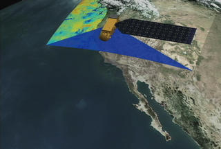
One of our primary tools for observing our environment are remote sensing satellites. With their sensors they can see, or sense reflected light from our oceans, land and atmosphere and help monitor their condition along with many living organisms that live within them. These satellites help us understand the overall state of health and condition of our planet.
Available formats:
703 x 480
TIFF
493 KB
320 x 218
JPEG
12 KB
|
|

|
|
Anacapa Island, one of the Channel Islands off the coast of California.
Available formats:
706 x 480
TIFF
340 KB
320 x 217
JPEG
2 KB
|
|
|
|
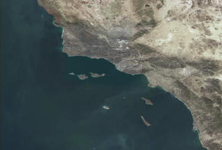
The Channel Islands off the coast of California.
Available formats:
706 x 480
TIFF
452 KB
320 x 217
JPEG
9 KB
|
|
|
|
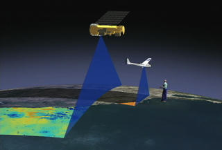
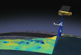
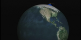
The big picture of remote sensing, we have multiple sensors on satellites flying at about 7 km per second above the earth gathering data over vast areas.
Available formats:
705 x 480
TIFF
358 KB
320 x 217
JPEG
7 KB
|
|
|
|
At the same time airplanes flying over the same area of interest gathering more detail data, or what is called higher resolution data, and finally, you have a person doing the ground truthing, collecting information that will be used to help validate and calibrate aerial and spaceborne remote sending instruments.
Available formats:
706 x 480
TIFF
388 KB
320 x 217
JPEG
9 KB
|
| Animation Number: | 2674 |
| Animators: | Greg Shirah (SVS) (Lead) |
| | Stuart A. Snodgrass (SVS) |
| | Lori Perkins (SVS) |
| Completed: | 2003-01-13 |
| Scientist: | Pat Coronado (NASA/GSFC) |
| Narrator: | Pat Coronado |
| Series: | Narrated Movies |
| Video: | SVS2003-0002 * |
Keywords:
SVS
>> Remote Control Airplanes
SVS
>> Remote Sensing
DLESE
>> Technology
|
|
Please give credit for this item to
NASA/Goddard Space Flight Center
Scientific Visualization Studio |
*Please note: the SVS does not fulfill requests for copies of the tapes in our library. On some of our animation pages, there is a direct link to a video distribution service from which tapes, handled by the Public Affairs Office (PAO)/Goddard TV, including some of our animations may be ordered. General information on this service can be found here. |
|
Back to Top
|

