
 Feeds & Data
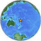
Magnitude 4.5 - FIJI REGION
2008 September 15 02:31:36 UTC
Earthquake Details
| Magnitude | 4.5 |
|---|---|
| Date-Time |
|
| Location | 20.108°S, 177.744°W |
| Depth | 504.3 km (313.4 miles) |
| Region | FIJI REGION |
| Distances | 115 km (70 miles) ENE of Ndoi Island, Fiji 285 km (175 miles) WNW of NUKU'ALOFA, Tonga 460 km (285 miles) ESE of SUVA, Viti Levu, Fiji 1995 km (1240 miles) NNE of Auckland, New Zealand |
| Location Uncertainty | horizontal +/- 7.4 km (4.6 miles); depth +/- 9.7 km (6.0 miles) |
| Parameters | NST= 98, Nph= 98, Dmin=515.3 km, Rmss=0.72 sec, Gp=122°, M-type=body magnitude (Mb), Version=7 |
| Source |
|
| Event ID | us2008wzaf |
- This event has been reviewed by a seismologist.
- Did you feel it? Report shaking and damage at your location. You can also view a map displaying accumulated data from your report and others.
Earthquake Maps
Earthquake Location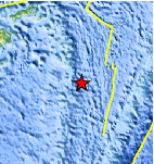
Location Maps
Historical Seismicity
Seismic Hazard Map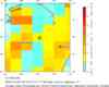
EQ Density Map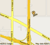
Google Map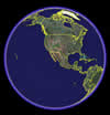
Google Earth KML
(Requires Google Earth)- Did you feel it? Report shaking and damage at your location. You can also view a map displaying accumulated data from your report and others.
Scientific & Technical Information
 Historic Moment Tensor Solutions
- Preliminary Earthquake Report
- U.S. Geological Survey, National Earthquake Information Center:
World Data Center for Seismology, Denver
