
 Feeds & Data
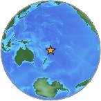
Magnitude 4.9 - SOUTH OF THE FIJI ISLANDS
2008 September 14 20:18:53 UTC
Earthquake Details
| Magnitude | 4.9 |
|---|---|
| Date-Time |
|
| Location | 23.610°S, 177.321°W |
| Depth | 198 km (123.0 miles) |
| Region | SOUTH OF THE FIJI ISLANDS |
| Distances | 345 km (215 miles) SW of NUKU'ALOFA, Tonga 355 km (220 miles) SSE of Ndoi Island, Fiji 650 km (405 miles) SSW of Neiafu, Tonga 1650 km (1030 miles) NNE of Auckland, New Zealand |
| Location Uncertainty | horizontal +/- 7.9 km (4.9 miles); depth +/- 12.5 km (7.8 miles) |
| Parameters | NST= 91, Nph= 91, Dmin=810 km, Rmss=0.8 sec, Gp= 94°, M-type=body magnitude (Mb), Version=Q |
| Source |
|
| Event ID | us2008wybp |
- This event has been reviewed by a seismologist.
- Did you feel it? Report shaking and damage at your location. You can also view a map displaying accumulated data from your report and others.
Earthquake Maps
Earthquake Location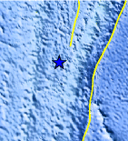
Location Maps
Historical Seismicity
Seismic Hazard Map
EQ Density Map
Google Map
Google Earth KML
(Requires Google Earth)- Did you feel it? Report shaking and damage at your location. You can also view a map displaying accumulated data from your report and others.
Scientific & Technical Information
 Historic Moment Tensor Solutions
- Preliminary Earthquake Report
- U.S. Geological Survey, National Earthquake Information Center:
World Data Center for Seismology, Denver
