
 Feeds & Data
Magnitude 5.9 - KOMANDORSKIYE OSTROVA, RUSSIA REGION
2008 September 12 23:07:51 UTC
Earthquake Details
| Magnitude | 5.9 |
|---|---|
| Date-Time |
|
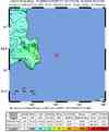
| Location | 56.352°N, 164.054°E |
| Depth | 14.9 km (9.3 miles) (poorly constrained) |
| Region | KOMANDORSKIYE OSTROVA, RUSSIA REGION |
| Distances | 175 km (110 miles) NW of Nikol'skoye, Komandorskiye Ostrova, Rus. 400 km (250 miles) S of Il'pyrskiy, Russia 510 km (315 miles) NE of Petropavlovsk-Kamchatskiy, Russia 6690 km (4150 miles) NNE of MOSCOW, Russia |
| Location Uncertainty | horizontal +/- 5.3 km (3.3 miles); depth +/- 15.9 km (9.9 miles) |
| Parameters | NST=264, Nph=264, Dmin=509.5 km, Rmss=0.83 sec, Gp= 54°, M-type=regional moment magnitude (Mw), Version=9 |
| Source |
|
| Event ID | us2008wwcp |
- This event has been reviewed by a seismologist.
- Did you feel it? Report shaking and damage at your location. You can also view a map displaying accumulated data from your report and others.


Earthquake Maps


Scientific & Technical Information

- Preliminary Earthquake Report
- U.S. Geological Survey, National Earthquake Information Center:
World Data Center for Seismology, Denver
