
 Feeds & Data
Magnitude 5.2 - SOUTHERN IRAN
2008 September 11 02:16:09 UTC
Earthquake Details
| Magnitude | 5.2 |
|---|---|
| Date-Time |
|
| Location | 26.915°N, 55.754°E |
| Depth | 10 km (6.2 miles) set by location program |
| Region | SOUTHERN IRAN |
| Distances | 60 km (35 miles) WSW of Bandar-e Abbas, Iran 90 km (55 miles) NNW of Al Khasab, Oman 125 km (80 miles) N of Ra's al Khaymah, United Arab Emirates 1050 km (650 miles) SSE of TEHRAN, Iran |
| Location Uncertainty | horizontal +/- 10.9 km (6.8 miles); depth fixed by location program |
| Parameters | NST= 45, Nph= 45, Dmin=>999 km, Rmss=0.9 sec, Gp=108°, M-type=body magnitude (Mb), Version=6 |
| Source |
|
| Event ID | us2008wvan |
- This event has been reviewed by a seismologist.
- Did you feel it? Report shaking and damage at your location. You can also view a map displaying accumulated data from your report and others.
Earthquake Maps

Earthquake Location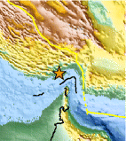
Location Maps
Historical Seismicity
Seismic Hazard Map
EQ Density Map
Google Map
Google Earth KML
(Requires Google Earth)- Did you feel it? Report shaking and damage at your location. You can also view a map displaying accumulated data from your report and others.
Scientific & Technical Information
 Historic Moment Tensor Solutions
Additional Information, News Reports
- Preliminary Earthquake Report
- U.S. Geological Survey, National Earthquake Information Center:
World Data Center for Seismology, Denver
