
 Feeds & Data
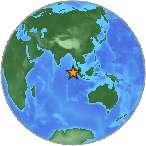
Magnitude 4.8 - SIMEULUE, INDONESIA
2008 September 10 04:02:27 UTC
Earthquake Details
| Magnitude | 4.8 |
|---|---|
| Date-Time |
|
| Location | 2.427°N, 96.319°E |
| Depth | 38.1 km (23.7 miles) |
| Region | SIMEULUE, INDONESIA |
| Distances | 285 km (180 miles) WNW of Sibolga, Sumatra, Indonesia 290 km (180 miles) WSW of Medan, Sumatra, Indonesia 605 km (375 miles) W of KUALA LUMPUR, Malaysia 1500 km (930 miles) NW of JAKARTA, Java, Indonesia |
| Location Uncertainty | horizontal +/- 18.4 km (11.4 miles); depth +/- 22 km (13.7 miles) |
| Parameters | NST= 49, Nph= 49, Dmin=574.6 km, Rmss=1.01 sec, Gp=130°, M-type=body magnitude (Mb), Version=R |
| Source |
|
| Event ID | us2008wuar |
- This event has been reviewed by a seismologist.
- Did you feel it? Report shaking and damage at your location. You can also view a map displaying accumulated data from your report and others.
Earthquake Maps
Earthquake Location
Location Maps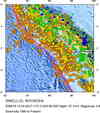
Historical Seismicity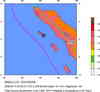
Seismic Hazard Map
EQ Density Map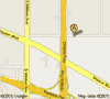
Google Map
Google Earth KML
(Requires Google Earth)- Did you feel it? Report shaking and damage at your location. You can also view a map displaying accumulated data from your report and others.
Scientific & Technical Information
 Historic Moment Tensor Solutions
- Preliminary Earthquake Report
- U.S. Geological Survey, National Earthquake Information Center:
World Data Center for Seismology, Denver
