
 Feeds & Data
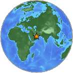
Magnitude 6.1 - SOUTHERN IRAN
2008 September 10 11:00:34 UTC
Earthquake Details
| Magnitude | 6.1 |
|---|---|
| Date-Time |
|
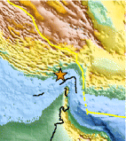
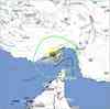
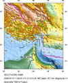
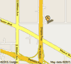
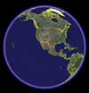
| Location | 26.823°N, 55.825°E |
| Depth | 15 km (9.3 miles) set by location program |
| Region | SOUTHERN IRAN |
| Distances | 60 km (40 miles) SW of Bandar-e Abbas, Iran 80 km (50 miles) NNW of Al Khasab, Oman 115 km (70 miles) N of Ra's al Khaymah, United Arab Emirates 1065 km (660 miles) SSE of TEHRAN, Iran |
| Location Uncertainty | horizontal +/- 4.4 km (2.7 miles); depth fixed by location program |
| Parameters | NST=243, Nph=243, Dmin=72.5 km, Rmss=0.98 sec, Gp= 18°, M-type=regional moment magnitude (Mw), Version=S |
| Source |
|
| Event ID | us2008wua9 |
- This event has been reviewed by a seismologist.
- Did you feel it? Report shaking and damage at your location. You can also view a map displaying accumulated data from your report and others.
Earthquake Summary
Felt Reports
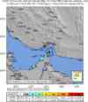
Seven people killed and about 45 injured, 15 of those on Qeshm. Damage to numerous villages in Hormozgan Province. Felt at Bandar-e Abbas. Felt (IV) at Ajman and Ras al Khaymah; (III) at Abu Zabi, Dubayy and ash-Shariqah, United Arab Emirates. Also felt at al-Ayn and al-Fujayrah. Felt (II) at ad-Dawhah, Qatar.
Earthquake Maps
Scientific & Technical Information

Additional Information, News Reports
- Preliminary Earthquake Report
- U.S. Geological Survey, National Earthquake Information Center:
World Data Center for Seismology, Denver
