
NOTES
PDF Version of this document. To view or print a document in PDF format, download the free Adobe Acrobat Reader.
Moving your mouse over the thumbnail photos will provide a brief description of the photo. To see enlargements of the thumbnail photos and a brief description of the photo, click on the photo.
The Abandoned Mine Lands Initiative is part of a larger strategy of the U.S. Department of the Interior and the U.S. Department of Agriculture to clean up Federal lands contaminated by abandoned mines.
 D |
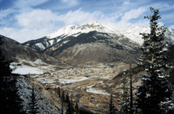
Thousands of abandond hard-rock metal mines (such as gold, copper, lead, and zinc) have left a dual legacy across the Western United States. They reflect the historic development of the west, yet at the same time represent a possible threat to human health and local ecosystems.
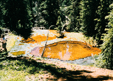
Abandoned Mine Lands (AML) are areas adjacent to or affected by abandoned mines. AML's often contain unmined mineral deposits, mine dumps (the ore and rock removed to get to the ore deposits), and tailings (the material left over from the ore processing) that contaminate the surrounding watershed and ecosystem. For example, streams near AML's can contain metals and (or) be so acidic that fish and aquatic insects cannot live in them.
Many of these abandoned hard-rock mines are located on or adjacent to public lands administered by the Bureau of Land Management, National Park Service, and U.S. Forest Service. These federal land management agencies and the USGS are committed to mitigating the adverse effects that AML's can have on water quality and stream habitats.
 D |
The USGS AML Initiative began in 1997 and will continue through 2001 in two pilot watersheds - the Boulder River basin in southwestern Montana and the upper Animas River basin in southwestern Colorado. The USGS is providing a wide range of scientific expertise to help land managers minimize and, where possible, eliminate the adverse environmental effects of AML's. USGS ecologists, geologists, water quality experts, hydrologists, geochemists, and mapping and digital data collection experts are collaborating to provide the scientific knowledge needed for an effective cleanup of AML's.
Goals of the USGS AML Initiative:
USGS Research Is Making A Difference
 D |
 D |
The Future of AML Initiative Research
USGS AML Initiative activities will conclude in the year 2001 with a summary of lessons learned for successful implementation of a watershed approach to characterize contamination from AML. Land managers will then be able to apply these lessons to remediate AML sites in other watersheds. One lesson already learned by the USGS is that the success of this initiative depends upon an interdisciplinary team of scientists working together with Federal land managers to provide science-based solutions to AML reclamation.
Information
For more information on Abandoned Mine Lands research at the USGS, please visit our Web sites at http://amli.usgs.gov/amli/ and http://www.usgs.gov.

![]() U.S. Department of the Interior |
U.S. Geological Survey
U.S. Department of the Interior |
U.S. Geological Survey
URL: http://www.usgs.gov/themes/factsheet/095-99/index.html
Page Contact Information:
Ask USGS
Page Last Modified: 25-Sep-2002@10:56