 Icebergs can be sneaky. Even the jumbo-sized icebergs of the South Atlantic could, until recently, lurk beneath clouds or in darkness out of sight of most satellite observers.
The SeaWinds instrument has changed all that. SeaWinds is a scatterometer flying on NASA's QuikScat satellite. A second SeaWinds instrument will launch on Japan's Advanced Earth Observation Satellite 2 on December 13. A scatterometer sends radar signals to Earth's surface and receives the scattered energy back. The instrument works day and night through clear or cloudy skies. While designed to measure the speed and direction of near-surface ocean winds, SeaWinds has been proven to have another talent: It can track large icebergs and map sea ice.
Being able to monitor these floating frozen mountains and vast plains of moving ice has immediate practical applications. Ship captains need to know when an iceberg might drift into their paths and when fast-changing sea ice may make getting in or out of a port impossible.
 |
| Artist's concept of Adeos 2 satellite with SeaWinds instrument on board |
Take the case of the German ship Magdalena Oldendorff trapped in frozen Antarctic waters since June. "We used scatterometer images to map the ice for the Argentinean ice breaker that went down to try to get the ship out," says Cheryl Bertoia, deputy director of the National Ice Center. The center is the U.S. Navy/National Oceanic and Atmospheric Administration agency charged with tracking icebergs in the Southern Hemisphere and mapping sea ice globally. "The ice was very thick and moving rapidly. The ice motion was more powerful than the ships' engines and was forcing the ships to move west when they wanted to move east. We did an animation of QuikScat images of the ice pack to determine the predominant ice motion to help the ships' captains to make navigation decisions."
In the end, the icebreaker had to go home alone, and the Magdalena, with its passengers and most of its crew airlifted to safety, awaits the spring thaw. By then, two SeaWinds instruments will be aloft to help map its path to freedom.
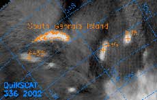 |
| QuikScat data showing South Georgia Island, in the South Atlantic, surrounded by icebergs. The island was the site of a whaling station from which Ernest Shackleton was finally able to begin rescue of his crew after being stranded for two years in Antarctica. |
Tracking and monitoring icebergs and sea ice also has important long-term uses, such as helping to answer some burning questions about climate. For example, scientists have noted that the number of Antarctic icebergs seems to on the rise and wondered if global warming could be the reason. To investigate, Bertoia, Professor David Long and Jarom Ballantyne of Brigham Young University reprocessed data from SeaWinds on QuikScat and earlier scatterometers going back about 30 years.
"We found that there were icebergs out there that had not been previously counted," says Long, "and that the number of icebergs has remained roughly constant from 1978 to the late 1990s." While global warming is real, says Long, the increase in the number of icebergs reported by the National Ice Center is the result of better tracking methods rather than climate change. The results of the study appeared in the October 15, 2002 issue of EOS Transitions.
Long, director of Brigham Young University's Center for Remote Sensing, is a member of the SeaWinds science team. He and his research group were the first to figure out how to reveal the ice details by combining observations from multiple scatterometer passes. "A scatterometer makes an indirect measurement of ocean winds and their direction by looking at surface roughness," explains Long. "The ocean surface is roughened by waves. The more waves, the more wind. But the scatterometer's radar measurements provide information over land as well as the oceans."
 |
| Dr. Long used QuikScat data to detect this iceberg in the Drake Passage between South America and Antarctica |
SeaWinds on QuikScat quickly showed its potential for spotting icebergs. Creating images with the first data they received from the instrument, Long and his group made a startling discovery. "A graduate student said 'there's a big iceberg out there. Shouldn't you tell someone about it,'" says Long. "I assumed that the National Ice Center already knew all about it, but when we called them later to ask for identification, they told us that they didn't know there was an iceberg in that location." It turned out that the center had been tracking the Rhode Island-sized iceberg, called B10A, for several years. However, a few months before SeaWinds spotted it, B10A had eluded traditional tracking methods long enough to drift into a completely new position and was a potential threat to shipping.
That was in 1999. Today, Long and his group keep daily track of South Atlantic icebergs with SeaWinds on QuikScat and provide the data to the National Ice Center. "Right now we do more than half of our iceberg tracking with SeaWinds," says Bertoia. "The other sensors that we use are visible and infrared sensors. When it's cloudy or dark, these sensors are not very useful because they cannot image the earth's surface in those conditions. In the South Atlantic, it's cloudy or dark about 70 percent of the time."
"We're now tracking about 30 large icebergs and about 20 small ones," says Long. Two of them are giants. The largest, C19, is 31 kilometers by 202 kilometers (17 by 109 nautical miles). Long and the National Ice Center will be watching C19 and its icy colleagues until they break up or melt, a process that can take months or decades. "It depends on the path they take," says Long. "If they get caught in shallow water, they will ground and can be stuck for years at a time. Then suddenly, they can move and disappear within months."
"SeaWinds tracking of icebergs is truly paving the way to a major improvement in our knowledge of iceberg production in the Antarctic," says JPL glaciologist Dr. Eric Rignot, "which is at present one of the least well-known components of the mass balance of the ice sheet."


