+ View the NASA Portal
-
Latest Images
-
Icebergs
-
Hurricane Season 2008
-
Hurricane Season 2007
-
Hurricane Season 2006
-
Hurricane Season 2005
-
Hurricanes/Typhoons
-
Animations
-
QuikSCAT Data
-
NSCAT Data
-
Early Images
-
Miscellaneous Images
-
Related Data
Early Images
Three Candles for QuikScat
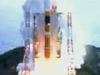
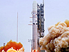
Launch of Adeos-II, with SeaWinds on board
Launch of Adeos-II, with SeaWinds on board (Image courtesy of NASDA)
Launch of Adeos-II, with SeaWinds on board (Image courtesy of NASDA)
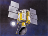
NASA's QuikSCAT Spacecraft Turns Operational
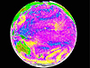
First image from SeaWinds instrument
Santa Ana Winds Over Los Angeles
SeaWinds/Oceans, Land, Polar Regions
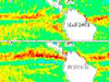
SeaWinds Captures Fury of Typhoon Olgaane
SeaWinds Captures Fury of Typhoon Olga
Seawinds On Midori-2 Data Now Available
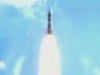
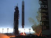
Lift-Off! At 7:15 PM (PDT) QuikSCAT rose from the pad at Space Launch Complex 4 West at Vandenberg Air Force Base in California.
Lift-Off! At 7:15 PM (PDT) QuikSCAT rose from the pad at Space Launch Complex 4 West at Vandenberg Air Force Base in California.
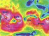
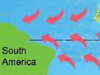
Satellite Sees Double Zones of Converging Tropical Winds
Intertropical convergence zone
SeaWinds Captures Fury of Typhoon Olga
Seawinds On Midori-2 Data Now Available
PRIVACY/COPYRIGHT
SITEMAP
CONTACT US
Site Manager:
Peter Falcon
Webmaster:
Cecelia Lawshe