NSCAT, a microwave radar scatterometer, measured near-surface wind vectors
(both speed and direction) over the global oceans. This information is critical in determining
regional weather patterns and global climate. NSCAT had two major systems - the
spaceborne instrument system and the ground data processing system.
Mission
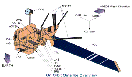
NSCAT was launched at 6:54 p.m. U.S. PDT, Friday, August 16, 1996, aboard the Advanced Earth
Observing Satellite (ADEOS), a mission of the National Space Development Agency of Japan.
ADEOS was launched into a near-polar Sun-synchronous orbit, by an H-II launch vehicle
from Japan's Tanegashima Space Center. The largest satellite ever developed by Japan,
ADEOS had a mass of approximately 3500 kilograms and a power-generation capability of
approximately 4500 watts; its overall dimensions at launch were 4 x 4 x 5 meters. When the NSCAT
antenna and the solar array paddle were deployed, the satellite was an impressive 11 meters in
height and the solar array extends outward 29 meters.
Science Objectives
-
Acquire all-weather high-resolution measurements of near-surface winds over the global oceans.
-
Determine atmospheric influences, ocean response and air-sea interactions on various spatial and temporal
scales.
-
Develop improved methods of assimilating wind data into numerical weather and wave prediction
models.
-
Combine wind data with measurements from various scientific disciplines to understand processes of global
climatic change and weather.
Measurements

-
The instrument was operated continuously at a frequency of 13.995 GHz.
-
Six dual-polarized, 3-meter long, stick-like antennas collected backscatter data with a resolution of 50 km for
nine months before loss.
-
Backscatter data was combined and processed to yield 268,000 globally distributed wind vectors per
day.
Instrument Description
- Mass: 280 kg
- Power: 240 W
- Data rate: 3.2 Kbps
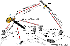
Every two days, under all weather and cloud conditions, NSCAT
measured wind speeds and directions over at least 90% of the Earth's
ice-free oceans. Since oceans cover approximately 70% of Earth's
surface, NSCAT played a key role in scientists' efforts
to understand and predict complex global weather patterns and
climate systems. NSCAT used eight antenna beams to scan two wide
bands of ocean, one on each side of the instrument's orbital
path. NSCAT transmited short pulses of microwave energy to probe
ocean surfaces and then measured the reflected or backscattered
power. Variations in the magnitude of this backscattered power
are caused by changes in small (centimeter-sized), wind-driven
waves. Using a method called Doppler processing (a change
in the observed frequency of the radio waves due to relative motion
of source and observer), the measured backscattered power was separated
into cells at specific locations on Earth's surface; these
were then transmitted to the ground for processing. During ground
processing, wind direction and speed was determined from these
variations. Within two weeks of receiving the raw data, the ground
system processed wind measurements.
NASA sponsors a team of scientific investigators who served as
project advisors during the development of the NSCAT instrument
and ground data processing system. These investigators conduct
research based on NSCAT data. Their studies are expected to lead
to improved methods of global weather forecasting and modeling
- and possibly to a better understanding of environment phenomena
(i.e. El Niño).
Learn about the launch site.