|
San Francisco
Click Image to Enlarge

(JPG)
(881 KB) ( 1,367 x 1,800 ) |
Click Image to Enlarge

(MOV)
(29.9 MB) ( 320 x 240 )
|
Click Image to Enlarge
(JPG)
(2.0 MB) ( 4,000 x 4,800 ) |
Click Image to Enlarge

(JPG)
(558 KB) ( 2,000 x 2,440 )
|
|
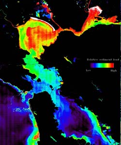
UPPER LEFT: This image of the San Francisco Bay region was acquired on March 3, 2000, and covers an area 60 kilometers (37 miles) wide and 75 kilometers (47 miles) long in three bands of the reflected visible and infrared wavelength region. The combination of bands portrays vegetation in red, and urban areas in gray. Sediment in the Suisun Bay, San Pablo Bay, San Francisco Bay, and the Pacific Ocean shows up as lighter shades of blue. Along the west coast of the San Francisco Peninsula, strong surf can be seen as a white fringe along the shoreline. A powerful rip tide is visible extending westward from Daly City into the Pacific Ocean. In the lower right corner, the wetlands of the South San Francisco Bay National Wildlife Refuge appear as large dark blue and brown polygons. The high spatial resolution of ASTER allows fine detail to be observed in the scene. The main bridges of the area (San Mateo, San Francisco-Oakland Bay, Golden Gate, Richmond-San Rafael, Benicia-Martinez, and Carquinez) are easily picked out, connecting the various communities in the Bay area. Shadows of the towers along the Bay Bridge can be seen over the adjacent bay water. With enlargement the entire road network can be easily mapped; individual buildings are visible, including the shadows of the high-rises in downtown San Francisco.
UPPER RIGHT: This animated fly-over the San Francisco area was produced by draping the image data (seen at left) over a high resolution digital elevation model derived from US Geological Survey topographic data.
LOWER RIGHT: The color coded temperature imag
|
Please give credit for these images to:
NASA/GSFC/METI/ERSDAC/JAROS,
and U.S./Japan ASTER Science Team
|


