|
GNOME and Deepwater Incidents
 |
|
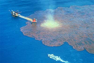
Blowout of IXTOC I exploratory well, June 3, 1979, in the Bay of Campeche off Ciudad del Carmen, Mexico.
|
Offshore development of oil reserves is moving into deeper and deeper water. Instead of hundreds of feet, development is now occurring at thousands of feet, with a few wells below 10,000 feet of seawater (see the link to the MMS Technical Announcement, Deepwater in the Gulf of Mexico: America's Emerging Frontier, below). Because the ocean is affected by winds at the surface and is density stratified, the profiles of temperature, salinity, and currents are not constant from the surface to the ocean bottom. Oil and gas released at the bottom are likely to reach the surface some distance from the "x" on the chart where they were released. NOAA's Office of Response and Restoration (OR&R) is involved in modeling research to develop the science and tools that would be needed in event of a deepwater accident. OR&R's trajectory model, GNOME, has undergone some modifications, and we've prepared a document to help responders prepare for the increased data needs related to deepwater development.
Responding to Deepwater Incidents
NOAA OR&R works closely with responders during spills and near-spills. The largest blowout affecting U.S. waters was the IXTOC I exploratory well in 1979. There have been no deepwater blowouts in the U.S., but we are working with the USCG, response agencies, and oil companies to be ready in case a blowout occurs. (Beegle-Krause and Lynch, 2005)
From our work with responders, we have learned that the trajectory modeling and environmental and human health and safety risks are different for deepwater spills. For example, we need to predict how far away and in what direction the oil could surface from a deepwater release. Responders are concerned about the potential dangers of natural gas or methane reaching the surface. In order to address these concerns, we need more information about the release particulars and the water column above the well. Getting information takes time, and we hope that development will involve planning, and that planning will include gathering data sources ahead of time. In particular, oceanic measurements of temperature, salinity, and currents are usually done in areas before a well is built. These data could be useful in a response. Trajectory modeling also requires more information on the release and chemistry of the oil and gas released. Gathering this information ahead of time speeds up the response time for the trajectory modelers in OR&R. At the bottom of this page, we've provided the Deepwater Spill Incident Data Preparation Sheet (in PDF format) to aid in deepwater planning and incident management.
Combining GNOME with CDOG
One portion of GNOME development is directed at connecting GNOME to the Clarkson Deepwater Oil and Gas model (CDOG) (see link below). The CDOG model is a deepwater oil spill computer model that was developed by Clarkson University researchers, under the direction of Dr. Poojitha Yapa (see link below). CDOG can closely simulate the behavior of oil or gas in very deep water, so is a useful tool for contingency planning, ecological risk assessment, and decision-making during emergencies.
When data about a spill is entered into the CDOG model, the program predicts whether gases will come to the surface, where the oil and gas will surface, and in what concentrations. Released gas may do one of two things: it may dissolve in the water, thus rendering it harmless if well-diluted, or it could come to the surface. If the gas reaches the surface in a large quantity, it poses a hazard due to its toxicity and flammability. For example, if a large amount of gas comes to the surface near a drilling platform where people are working, it could catch fire and cause an explosion. CDOG simulates both the dynamics of the jet/plume phase and the far-field conditions during the rise of oil/gas hydrates through the water column. CDOG allows gas hydrates to separate from the main plume if there are strong cross currents. Despite the comprehensive nature of CDOG, it is designed to simulate the oil and gas behavior only until they reach the water surface. Also, CDOG does not include a graphic user interface (GUI) or data visualization feature. Our project of combining CDOG with GNOME enables users to run CDOG using a GUI, and then transition to GNOME to predict surface trajectories and weathering processes once oil reaches the water surface. The integration of CDOG and GNOME allows us to run complete scenarios?the types that are required in comprehensive contingency planning.
Our project of integrating CDOG and GNOME is still under development.
Acknowledgements
The project of integrating GNOME and CDOG is funded by the Cooperative Institute for Coastal and Estuarine Environmental Technology (CICEET) through the University of New Hampshire and the Coastal Response Research Center (CRRC) at the University of New Hampshire (see links at page bottom).
References
Links to items mentioned on the page, as well as Clarkson University news articles about CDOG and Dr. Yapa. |
|
|
|
|
|
|
- GNOME References See the references related to the integration of GNOME with the CDOG model.
|
- Deepwater Publications Articles, papers, and reports by Dr. Poojitha Yapa and others at Clarkson regarding the behavior of oil and gas in deepwater incidents. [leaves OR&R site]
|
|
|
|
|
|
|
- Coastal Response Research Center (CRRC) The Coastal Response Research Center at the University of New Hampshire is focused on developing new approaches to spill response and restoration in marine and estuarine environments through research and synthesis of information. [leaves OR&R site]
|
Other pages in this series
|
- GNOME Back to the main GNOME page.
|
|