
|
|
|
|

|
Geographic information systems are not just maps, they are relational databases linked to geographic features that help users better query and visualize relationships among data and make those relationships easier to present. Researchers in the GIS Lab use SUN workstations--including a SPARC 20 and SPARC 1--Calcomp 9500 digitizer, a 486 PC, and several types of GIS software, primarily ARC/Info and Earth Resources Data Analysis System. ARC/Info is a vector-based GIS program produced by the Environmental Systems Research Institute; the ERDAS is a raster-based system. The vector-based GIS is better adapted for political boundaries and discontinuous data. However, ERDAS has superior image-processing capabilities.
The GIS's ability to manipulate, organize, and display detailed information about appliance type and ownership, demographic variables, and energy use has been invaluable to its users in the Energy Analysis Program's appliance standards group. The GIS is helping researchers fine-tune the appliance energy standards they are developing under a Congressional mandate, the National Appliance Energy Conservation Act. When completed, these standards will require 13 appliance types to meet uniform minimum energy-efficiency requirements in the U.S. Susan Mahler, Jim McMahon, and Xiaomin Liu are using the GIS to model the effects of proposed national appliance standards, examining the effects of different climates on energy consumption and studying the economics of efficient technologies in regions with differing energy prices.
|
|
|
|
|
|
|
|
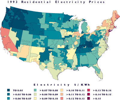
GIS software can help combine data sets with dissimilar boundaries, as in this map of annual cost of electricity for residential air conditioners.
Rich Brown and Jonathan Koomey are using the GIS for targeted marketing of energy-efficient residential products as part of a project funded by the Environmental Protection Agency. This project is helping the EPA design effective energy efficiency programs. They are developing a detailed, GIS-based model to identify regions and market segments in which energy-efficient technologies are technically feasible, cost-effective, and acceptable to consumers. The EPA then applies this information to the design of programs targeted at the most attractive market segments. The GIS allows the researchers to compile and understand larger, more detailed data sets than they have worked with in the past. This is critical to defining the appropriate markets for energy efficiency program implementation. Xiaomin Liu used ERDAS to create a different type of GIS database for the Center's Heat Islands/Cool Communities Project . Liu and Haider Taha created a database of the albedo (surface reflectivity) of Southern California using images taken from the AVHRR satellite. They worked with the albedo data in a meteorological model to simulate the Los Angeles basin's climate, including its temperature field. With an urban airshed model, they produced a map of ozone concentrations for the basin. The research will produce a better understanding of how air quality correlates with air temperature.
Others researchers are using the GIS Lab's capabilities to study indoor radon concentration in the U.S., and analyze thermal emissions in the Sacramento area. A project to analyze energy policy in China is in the formative stages.
--Allan Chen
![]()
Susan Mahler
Energy Analysis Program
(510) 486-4725; (510) 486-6996 fax