|
 |
 |
| Home | News | Organization |
|
|
Station List Observations Recent Historical Obs Search Ship Obs Report NOAA Obs APEX DART MMS ADCP TAO DODS HF Radar OSMC Dial-A-Buoy RSS Feeds Email Access Station Status NDBC Maintenance NDBC Platforms Partner Platforms Program Info About NDBC Met/Ocean Moored Buoy C-MAN TAO DART VOS CSP IOOS DAC Publications Hurricane Data Plots Mariners Weather Log Observing Handbook No. 1 Science Education FAQ Contact Us Links |
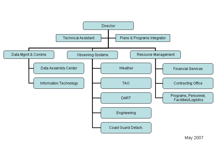
NDBC General InformationNDBC's CharterThe National Data Buoy Center (NDBC) manages the development, operations, and maintenance of the national data buoy network. It serves as the NOAA focal point for data buoy and associated meteorological and environmental monitoring technology. It provides high quality meteorological/environmental data in real time from automated observing systems that include buoys and a Coastal-Marine Automated Network (C-MAN) in the open ocean and coastal zone surrounding the United States. It provides engineering support, including applications development, and manages data buoy deployment and operations, and installation and operation of automated observing systems installed on fixed platforms. It manages the Volunteer Observing Ship (VOS) program to acquire additional meteorological and oceanographic observations supporting NWS mission requirements. It operates the NWS test center for all surface sensor systems. It maintains the capability to support operational and research programs of NOAA and other national and international organizations. NDBC's MissionNDBC provides comprehensive, reliable systems and marine observations to support the missions of the National Weather Service (NWS) and NOAA, promote public safety, and satisfy the future needs of our customers. NDBC's HistoryDuring the 1960's, approximately 50 individual programs were conducted by a variety of ocean-oriented agencies. In March 1966, the Ocean Engineering Panel of the Interagency Committee on Oceanography recommended that the United States Coast Guard (USCG) investigate the feasibility of a consolidated national data buoy system. As a result of that investigation, the National Council for Marine Research Resources and Engineering Development endorsed the formation of the National Data Buoy Development Program (NDBDP) in 1967. The NDBDP was created and placed under the control of the USCG. In 1970, NOAA was formed and the NOAA Data Buoy Office (NDBO) was created within the National Ocean Service (NOS) and located in Mississippi. In 1982, the NDBO was renamed NDBC and was placed under NOAA's NWS. The first buoys deployed by NDBC were the large 12-m discus hulls constructed of steel. These were generally deployed in deep water off the U.S. East Coast and in the Gulf of Mexico. The measurements taken by sensors onboard these buoys were surface measurements of pressure, temperature, and wind speed and direction. NDBC also devised a system of 10-m discus hulls that were less expensive to build and easier to maintain than the larger 12-m hulls. These stations were primarily funded by the NWS and were used to deliver scheduled observations to forecasters for predicting weather and issuing warnings. After some time, wave measurements were added to the surface meteorological measurements. By 1979, 16 stations were deployed in the Pacific, 7 in the Atlantic, and 3 in the Gulf of Mexico. Eight more stations were deployed in the Great Lakes after 1979. NDBC has also designed and deployed aluminum hulls. The advantages of these hulls are their cost effectiveness and transportability. Their smaller size and lighter weight allow for land transfer by truck. The boat-shaped hull developed by the U.S. Navy, called the Naval Oceanographic and Meteorological Automated Device (NOMAD), is an example of this aluminum hull design. These hulls are less costly to build and maintain and are as sturdy in high seas as the 12-m discus hulls. NDBC, in connection with the Woods Hole Oceanographic Institute, developed a smaller 3-m discus hull for use in less harsh conditions, such as in the coastal zone. Please see the hull description and sensor location Help file for more detailed information. Although an NWS center, NDBC actively supports a number of reimbursable buoy-related projects. These projects involve deploying buoys in the coastal zone for agencies such as the Minerals Management Service (MMS), U.S Army Corps of Engineers-Coastal Engineering Research Center (USA COE-CERC), the National Aeronautics and Space Administration (NASA), and other governmental agencies and private companies. Many of these organizations are interested in NDBC's directional wave measurements. NDBC has also been involved in the design, testing, evaluation, production, deployment, and operation of drifting buoys for the past 20 years. This involvement generally has been in conjunction with various scientific experiments, such as the First Global Experiment and the Tropical Ocean and Global Atmosphere (TOGA) Research Program in 1985. Currently, drifting buoys are being deployed in the North Pacific. Historical drifting buoy data are available in the TD-156 format from the National Climatic Data Center (NCDC). In 1982, in conjunction with the USCG's Lighthouse Automation and Modernization Program (LAMP), NDBC installed its first fixed station for the Coastal-Marine Automated Network (C-MAN). Its design allows for flexibility in terms of sensor requirements, data access, and installation demands. These C-MAN stations collect the weather observations that would have been lost when the USCG removed the station keepers from the coastal lighthouses under LAMP. Besides the baseline measurements of wind speed and direction, air temperature, and barometric pressure, measurements of continuous winds, relative humidity, precipitation, visibility, solar radiation, ocean currents at depth, sea water salinity, underwater light intensity, and others can be made. NDBC's OrganizationThe chart below outlines the internal organizational structure of NDBC.
NDBC and USCG PartnershipNDBC's history can be traced back to the late 1960s when buoy development and operation were conducted by the USCG. The program was transferred to NOAA in 1970, and its headquarters moved to SSC in Hancock County in southwest Mississippi. Through a Memorandum of Agreement, the USCG remains a critically important partner to NDBC, supplying transportation for buoy deployments, retrievals, and other maintenance.
|