|
 |
 |
| Home | News | Organization |
|
|
Station List Observations Recent Historical Obs Search Ship Obs Report NOAA Obs APEX DART MMS ADCP TAO DODS HF Radar OSMC Dial-A-Buoy RSS Feeds Email Access Station Status NDBC Maintenance NDBC Platforms Partner Platforms Program Info About NDBC Met/Ocean Moored Buoy C-MAN TAO DART VOS CSP IOOS DAC Publications Hurricane Data Plots Mariners Weather Log Observing Handbook No. 1 Science Education FAQ Contact Us Links |
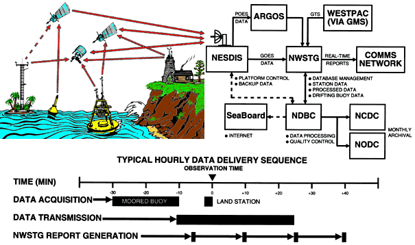
How do the measured data get from the buoy or C-MAN site to the various users worldwide?
The electronic payloads installed on moored buoys and at C-MAN sites generally transmit data to one of NOAA's Geostationary Operational Environmental Satellites (GOES) each hour. The GOES relays the data message to the NESDIS Data Acquisition Processing System (DAPS) at Wallops Island, VA. Next, DAPS sends the data to the National Weather Service Telecommunications Gateway (NWSTG) where gross data quality control is performed before the data are distributed in meteorological codes in real time (i.e., usually in less than 30 minutes). A few WESTPAC C-MAN stations located in Micronesia are at the fringe of or lie outside the NOAA GOES footprint. Data from these stations may be transmitted via either GOES or NOAA polar orbiting environmental satellites (POES), depending upon which provides better data relay capability. NDBC has even arranged with the Japanese Meteorological Agency to transmit data from one WESTPAC station through the Japanese geostationary satellite, referred to as GMS, via Tokyo to the NWSTG for appropriate processing and dissemination. NWSTG also sends the raw satellite messages and the NWSTG quality controlled data to NDBC. At NDBC, the data are recomputed from the satellite message to verify the accuracy of the NWSTG processing stream. Then, the data are put through a series of stringent automated and manual checks. Data that pass all of these checks are deemed suitable for archival at the National Climatic Data Center (NCDC) and the National Oceanographic Data Center (NODC). Because of the more stringent quality control performed by NDBC than by NWSTG, the data which NDBC archives are generally of better quality and are more complete than the data that are transmitted to the users by NWSTG in near real time. The measurements in the archive also are listed to a higher resolution. The differences can be attributed to the time constraints that NWSTG has to meet in order to distribute the data in real time. For detailed information, refer to: National Data Buoy Center, 1995: Automated data quality control checks and procedures of the National Data Buoy Center. NOAA Technical Report
|