|
|
- Advisories
- Forecasts
- Observations
- Java Tools »
- Related Information
- Contact Us
|
 |
 |
|
|
|
Aviation Area Forecasts (FA) Help
|
|
|
| NWS Product Description Document (PDD) ... |
An area forecast (FA) is a forecast of Visual Flight Rules (VFR) clouds
and weather conditions over an area as large as the size of several states. It must be
used in conjunction with the AIRMET Sierra (IFR)
bulletin for the same area in order to get a complete picture of the weather. The area
forecast together with the AIRMET Sierra bulletin are used to determine forecast enroute
weather and to interpolate conditions at airports which do not have a terminal forecast
(TAF) issued. FAs are issued 3 times a day from Kansas City for each of 6 areas in the
contiguous 48 states (domestic) as well as
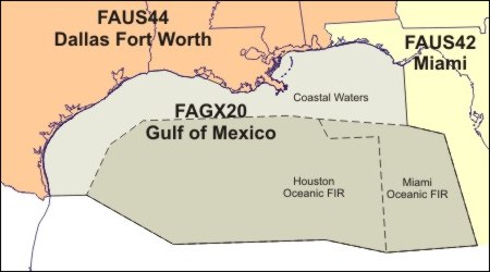
the Gulf of Mexico (FAGX) and Caribbean
(FACA).
Map of Current FAGX:
Detailed maps of domestic FA regions and
geographic areas are available in
GIF (185K) or PDF (4.3M) formats.
In Alaska, FAs are issued by
the Weather Service Forecast Office (WSFO) in Anchorage, Fairbanks, and Juneau for their
respective areas (Alaska). The WSFO in
Honolulu issues FAs for Hawaii (Hawaii).
The FA consists of a:
- 12 hour forecast plus a 6 hour outlook. All times are Coordinated Universal Time
(UTC). All distances except visibility are in nautical miles. Visibility is in
statute miles.
- synopsis section which is a brief summary of the location and
movement of fronts, pressure system, and circulation patterns for an 18
hour period.
- VFR clouds and weather section which is a 12 hour forecast, in
broad terms, of clouds and weather significant to flight operations plus a
6 hour categorical outlook. This section is usually several paragraphs.
AIRMET Sierra supplies information regarding Instrument Flight Rule (IFR)
conditions. The breakdown may be by states, by well known geographical areas,
or in reference to location and movement of a pressure system or front. A
categorical outlook, identified by OTLK, is included for each area
breakdown.
Amendments to the FA are issued as needed. An amended FA is identified
by AMD, a corrected FA by COR, and a delayed FA is
identified by RTD.
|
|
|

