|
GNOME's Trajectory Predictions
Now Showing: the Columbia River Estuary
GNOME uses wind and current information, along with information about the type of product spilled and the strength (magnitude) of turbulence expected in the estuary, to predict the trajectory of the oil. It displays its predicted trajectory as an animation in which the oil is depicted as a swarm of dots, called "splots," each representing a portion of the volume of spilled oil.
GNOME's Best Estimate
Use the links below to view GNOME's "best estimate" of the oil's trajectory. You'll see that GNOME predicts that most of the oil will move towards the northwest, and that by the end of the day, much of it will have beached along the northern (Washington State) bank of the river.
The "Minimum Regret" Case
Besides making a best estimate of the oil's trajectory, GNOME also can predict the effects of uncertainty in winds and currents (uncertainty arises from things like errors in forecasts of winds or current patterns). These effects are depicted in the trajectory animation below. In these animations, red dots mark additional places where oil may move, beyond the areas where GNOME's best estimate expects oil to travel. In a real-life event, roughly 90 percent of the time, the spilled oil is not expected to travel beyond the area covered by red dots (assuming that the scenario information has been correctly entered into the model and that our understanding of the underlying regional physical processes controlling the spill trajectory is correct).
Movies and Charts
Use either the larger or smaller of the movie files depending on the speed of your Internet connection. |
|
|
|
|
|
|
|
|
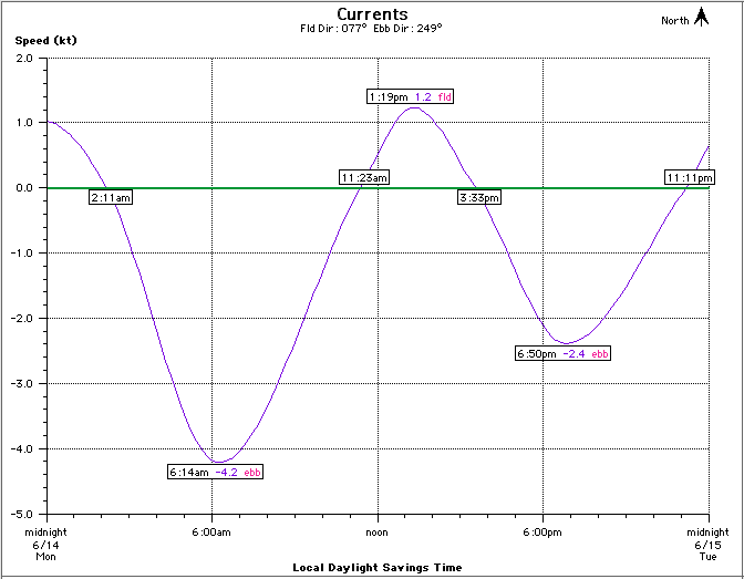
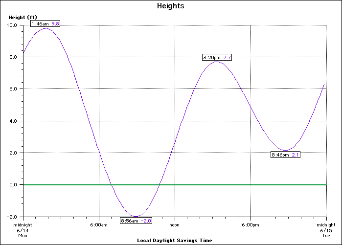
Current and Tide Charts
Use the links below to download current and tide charts for the date and location. |
|
|
|
|
Other Pages in this Series
|
- GNOME Back to the main GNOME page.
|
|

