|
|
- Advisories
- Forecasts
- Observations
- Java Tools »
- Related Information
- Contact Us
|
 |
 |
|
|
|
Mid Level SIGWX Charts Help
|
|
|
Description
The Aviation Weather Center (AWC) has the responsibility, as part of the World Area Forecast Center, Washington, to provide global weather forecasts of
significant weather phenomena. Presently, the AWC produces High Level Significant Weather charts covering two thirds of the globe, both
northern and southern hemispheres that are issued four times per day.
More recently the Aviation Weather Center has accepted the responsibility for routinely providing a Mid Level Significant
Weather chart, between FL100 and FL450, for the North Atlantic Ocean Region (NAT). The NAT chart implementation is scheduled for
Sept 15, 2003 with 0600Z forecast.
The presentation of significant weather on the mid level significant weather chart is similar in many respects to that on
High Level Significant Weather charts. The detail required however is more extensive because the bottom of the chart is now at FL100
instead of FL250. Aircraft flying at these lower levels in the atmosphere, below FL250, will more likely encounter larger areas of
icing and turbulence.
Availability
The North Atlantic Mid Level Significant Weather chart will be
transmitted along with the High Level Significant Weather charts. Transmission times for forecast packages are:
| Package | Issue Time |
|---|
| 24 hour forecast package valid at 00Z | 08Z |
| 24 hour forecast package valid at 06Z | 14Z |
| 24 hour forecast package valid at 12Z | 20Z |
| 24 hour forecast package valid at 18Z | 02Z |
|
The information placed on the Mid Level Significant Weather chart will be the combination of information imported from
the corresponding High Level Significant Weather chart and additional information generated by the meteorologist specifically for the
Mid Level chart.
WAFS Significant Weather (SIGWX) Data in BUFR
This document has been prepared by the World Area Forecast Centres (WAFCs) for the purpose of providing guidance to software developers
who have the task of constructing WAFS SIGWX BUFR visualisation software. The document is designed to assist developers in the
construction of compliant visualisation software that receives its data input from text files obtained from BUFR decoding software.
Forecast Elements
The Mid Level chart will include the following information:
 |
a) Thunderstorms and Surface frontal positions and movement; |
| b) Jet streams; |
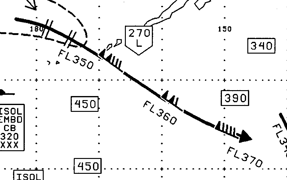 |
| * Jet Depth: The vertical depths to the 80 knot wind field above and below the jet steam using flight levels. Jet stream vertical depth forecasts are included when the maximum speed is 120 knots or more. More details ... |
 |
c) Tropopause heights; |
| d) Tropical Cyclones; |
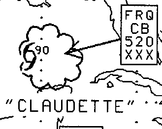 |
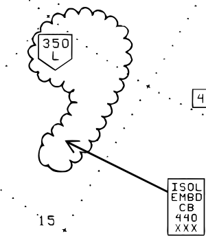
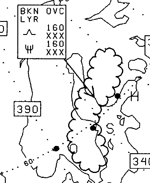
e) Moderate or Severe Icing;
f) Moderate or Severe Turbulence
(in cloud or in clear air);
|
 |
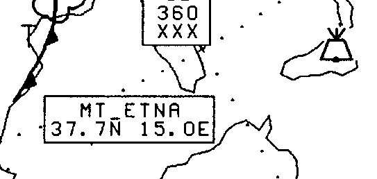 |
g) Volcanic Eruptions; |
| h) Widespread Sand Storms/Dust Storms; |
 |
| i) Release of Radioactive Materials; |
 |
To Receive the North Atlantic Mid Level Chart
The Aviation Weather Center provides dissemination via its International Flight Folder Documentation Program. To receive this
chart via automated facsimile service call 877-280-2811 and request document number 2135.
You may also provide comments on this sample chart. Send comments to:SWM@awc.kc.noaa.gov.
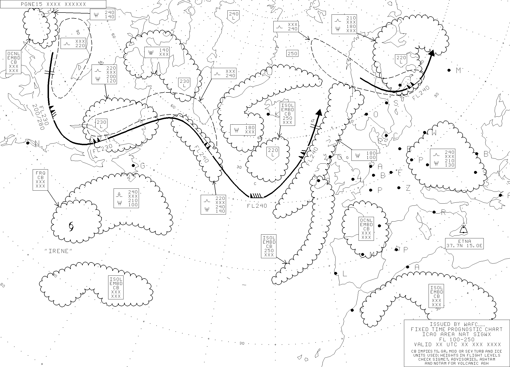 |
| Click on MAP to enlarge |
|
|


