|
|
 |
A Short Tour of the Cryosphere
|
|
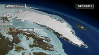
This narrated, 5-minute animation shows a wealth of data collected from satellite observations of the cryosphere and the impact that recent cryospheric changes are making on our planet. This is a shorter version of a narrated, 7 1/2 minute animation entitled 'A Tour of the Cryosphere'. See the above link for a detailed description of the full animation. Two sections have been removed from the original animation: one showing a flyby of the South Pole station and glaciers feeding the Ross Ice Shelf and one showing solar data related to the Earth's energy balance. For more information on the data sets used in this visualization, visit NASA's EOS DAAC website.
|
|
|
|
The short version of the Cryosphere Tour, with narration and music.
Duration: 5.0 minutes
Available formats:
160x80
PNG
21 KB
320x180
JPEG
15 KB
80x40
PNG
6 KB
720x480 (29.97 fps)
MPEG-2
189 MB
720x480 (29.97 fps)
Frames (WithLabels)
848x480 (29.969 fps)
MPEG-4
78 MB
How to play our movies
|
|

|
|
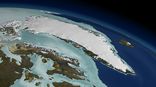
The short version of the Cryosphere Tour, with no narration or labels. (A label-only frame set is also provided.)
Available formats:
320x180
PNG
83 KB
720x480 (29.97 fps)
Frames (NoLabels)
720x480 (29.97 fps)
Frames (LabelLayer)
How to play our movies
|
| Animation Number: | 3355 |
| Animators: | Alex Kekesi (Lead) |
| | Cindy Starr (Lead) |
| | Ryan Boller |
| | Tom Bridgman |
| | Randall Jones |
| | Kevin Mahoney |
| | Horace Mitchell |
| | Marte Newcombe |
| | Lori Perkins |
| | Greg Shirah |
| | Stuart A. Snodgrass |
| | Eric Sokolowsky |
| Studio: | NASA |
| Completed: | 2006-05-12 |
| Scientists: | Walt Meier (NSIDC) |
| | Waleed Abdalati (NASA/HQ) |
| | Ronald Weaver (University of Colorado) |
| | Mary Jo Brodzik (University of Colorado) |
| | Richard Armstrong (University of Colorado) |
| Writers: | Jarrett Cohen (GST) |
| | Michael Starobin (HTSI) |
| Narrator: | Michael Starobin (HTSI) |
| Instruments: | Aqua/AMSR-E
|
| | Aqua/MODIS |
| | DMSP/SSMI |
| | DMSP/OLS |
| | GOES |
| | ICESat/GLAS |
| | Landsat-7/ETM+ |
| | Nimbus-7/SMMR |
| | QuikSCAT/SeaWinds |
| | RADARSAT-1/SAR |
| | SeaStar/SeaWiFS |
| | Terra/ASTER |
| | Terra/CERES |
| | Terra/MODIS |
| | SORCE/TIM |
| Data sets: | Blue Marble landcover
|
| | USGS/GTOPO30 |
| | ICESat/GLAS Cloud Height Profile |
| | MODIS/Terra Snow Cover Daily L3 Global 0.05Deg CMG (MOD10C1) |
| | Gridded Population of the World (Version 3 Beta) |
| | Infrared Global Geostationary Composite |
| | MODIS/Aqua Sea Ice Extent and Ice Surface Temperature Daily L3 Global 4km EASE-Grid Day (MYD29E1D) |
| | September Mean Sea Ice Concentration |
| | Monthly Sea Ice Concentration Climatology from 1979-2002 |
| | Daily L3 6.25 km 89 GHz Brightness Temperature (Tb) |
| | AMSR-E Level 3 12.5 km Sea Ice Concentration |
| | CERES Reflected Flux |
| | CERES Outgoing Thermal |
| | CERES Net Flux |
| | CERES Average Net Flux |
| | Circum-Arctic Map of Permafrost and Ground-Ice Conditions |
| | ERS SAR-derived Glacial Floes |
| | MODIS NDVI |
| | NSIDC World Glacier Inventory |
| | SeaWiFS NDVI |
| | SORCE Solar Flux |
| | SRTM |
| | Antarctic DEM |
| | SIR |
| Data Collected: | ASTER (05/30/2004)
AMSR-E Level 3 12.5 km Sea Ice Concentration (10/01/2002 - 06/23/2003)
AMSR-E Level 3 6.25 km Sea Ice Brightness Temperature (10/01/2002 - 06/23/2003)
MODIS Blue Marble Landcover
Infrared Global Geostationary Composite (a.k.a. GOES Cloud) (10/01/2002 - 03/31/2003) and (06/19/2003 - 06/22/2003)
Circum-Arctic Map of Permafrost and Ground-Ice Conditions (1997)
DMSP Operational Linescan System (OLS) (Earth-at-Night)
ERS SAR-derived Glacial Flows (2001)
GPW Population (SEDAC 1990 - 1995)
ICESat/GLAS Cloud Height Profile (09/30/2003 - 10/01/2003)
Landsat Imagery (07/07/2001, 05/20/2001, 05/23/2002, 05/19/2003)
MODIS NDVI (06/06/2002 - 09/14/2002) and (06/06/2003 - 09/14/2003)
MODIS imagery of Greenland (06/25/2003)
MODIS imagery of B-15A (11/09/2004, 11/15/2004, 11/19/2004, 11/21/2004, 11/26/2004, 12/02/2004, 12/04/2004, 12/07/2004, 12/10/2004, 12/13/2004, 12/20/2004, 12/23/2004, 01/02/2005, 01/11/2005, 01/12/2005, 01/14/2005, 01/17/2005, 01/18/2005, 01/21/2005, 01/26/2005)
MODIS imagery of Larsen (01/31/2002, 02/17/2002, 02/23/2002, 03/05/2002, 03/07/2002)
MODIS Daily Sea Ice Surface Temperature (07/04/2002 - 07/23/2003)
MODIS Daily Snow Cover (01/01/2002 - 06/30/2003)
NSIDC World Glacier Inventory (1999)
QuikSCAT Seawinds (03/09/2004 - 12/10/2004)
Radarsat SAR Imagery (09/26/1997 - 11/04/1997)
September Minimum Average Sea Ice Extent-15% mean contour derived from (1979 - 2002)
SeaWiFS NDVI (06/01/2002 - 12/31/2003)
NSIDC SSMI-derived Monthly Average Sea Ice Concentration derived from (1979 - 2002)
NSIDC SSMI-derived September Minimum Sea Ice Concentration years (1979 - 2004)
Topography (SRTM, USGS/GTOPO-30, Antarctic Digital Elevation Model (1999)) |
| Series: | Narrated Movies |
Keywords:
DLESE
>> Cryology
SVS
>> Sea Ice
SVS
>> Snow Cover
SVS
>> Snow and Ice
GCMD
>> EARTH SCIENCE
>> Cryosphere
>> Frozen Ground
>> Permafrost
GCMD
>> EARTH SCIENCE
>> Cryosphere
>> Glaciers/Ice Sheets
>> Glacier Motion/Ice Sheet Motion
GCMD
>> EARTH SCIENCE
>> Cryosphere
>> Glaciers/Ice Sheets
>> Glacier Topography/Ice Sheet Topography
GCMD
>> EARTH SCIENCE
>> Cryosphere
>> Glaciers/Ice Sheets
>> Glaciers
GCMD
>> EARTH SCIENCE
>> Cryosphere
>> Glaciers/Ice Sheets
>> Ice Sheets
GCMD
>> EARTH SCIENCE
>> Cryosphere
>> Sea Ice
>> Ice Growth/Melt
GCMD
>> EARTH SCIENCE
>> Cryosphere
>> Sea Ice
>> Ice Temperature
GCMD
>> EARTH SCIENCE
>> Cryosphere
>> Sea Ice
>> Sea Ice Concentration
GCMD
>> EARTH SCIENCE
>> Cryosphere
>> Sea Ice
>> Sea Ice Motion
GCMD
>> EARTH SCIENCE
>> Cryosphere
>> Snow/Ice
>> Ice Growth/Melt
GCMD
>> EARTH SCIENCE
>> Cryosphere
>> Snow/Ice
>> Ice Motion
GCMD
>> EARTH SCIENCE
>> Cryosphere
>> Snow/Ice
>> Ice Velocity
GCMD
>> EARTH SCIENCE
>> Cryosphere
>> Snow/Ice
>> Permafrost
GCMD
>> EARTH SCIENCE
>> Cryosphere
>> Snow/Ice
>> Snow Cover
GCMD
>> EARTH SCIENCE
>> Cryosphere
>> Snow/Ice
>> Snow/Ice Temperature
GCMD
>> EARTH SCIENCE
>> Hydrosphere
>> Glaciers/Ice Sheets
>> Glacier Motion/Ice Sheet Motion
GCMD
>> EARTH SCIENCE
>> Hydrosphere
>> Glaciers/Ice Sheets
>> Glacier Topography/Ice Sheet Topography
GCMD
>> EARTH SCIENCE
>> Hydrosphere
>> Glaciers/Ice Sheets
>> Glaciers
GCMD
>> EARTH SCIENCE
>> Hydrosphere
>> Glaciers/Ice Sheets
>> Ice Sheets
GCMD
>> EARTH SCIENCE
>> Hydrosphere
>> Snow/Ice
>> Ice Growth/Melt
GCMD
>> EARTH SCIENCE
>> Hydrosphere
>> Snow/Ice
>> Ice Motion
GCMD
>> EARTH SCIENCE
>> Hydrosphere
>> Snow/Ice
>> Ice Velocity
GCMD
>> EARTH SCIENCE
>> Hydrosphere
>> Snow/Ice
>> Permafrost
GCMD
>> EARTH SCIENCE
>> Hydrosphere
>> Snow/Ice
>> Snow Cover
GCMD
>> EARTH SCIENCE
>> Hydrosphere
>> Snow/Ice
>> Snow/Ice Temperature
SVS
>> Sea Ice Surface Temperature
|
This work has been visible on
'Research Shines Some Light On Mysteries of Antarctica' - Washington Post, Sunday, February 19, 2007. |
|
Please give credit for this item to
NASA/Goddard Space Flight Center Scientific Visualization Studio
Designed by
EOSDIS Outreach Team
ESDIS Science Operations Office
NASA Goddard Space Flight Center
Carol Boquist, NASA Goddard Space Flight Center
Jennifer Farnham-Brennan, Global Science and Technology, Inc.
Dr. Brian Krupp, Global Science and Technology, Inc.
Directed and Edited by
Dr. Horace Mitchell, NASA Goddard Space Flight Center
Written by
Jarrett Cohen, Global Science and Technology, Inc.
Michael Starobin, Honeywell Technology Solutions, Inc.
Narrated by
Michael Starobin, Honeywell Technology Solutions, Inc.
Audio Engineering by
Mike Velle, Honeywell Technology Solutions, Inc.
Music by
Michael Starobin, Honeywell Technology Solutions, Inc.
MODIS Snow and Ice data courtesy of
Dr. Dorothy Hall, NASA Goddard Space Flight Center
Dr. Vince Salomonson, NASA Goddard Space Flight Center
Dr. George Riggs, Science Systems and Applications, Inc.
Arctic Sea Ice data courtesy of the
National Snow and Ice Data Center
Cooperative Institute for Research in the Environmental Sciences
University of Colorado
MODIS Imagery courtesy of the
MODIS Land Rapid Response Project
NASA Goddard Space Flight Center
and the
University of Maryland
Jacques Descloitres, Science Systems and Applications, Inc.
Jeffrey E. Schmaltz, Science Systems and Applications, Inc.
Blue Marble MODIS data composite courtesy of the
MODIS Science Team
NASA Goddard Space Flight Center
and the
NASA Earth Observatory
Reto Stockli, Science Systems and Applications, Inc.
RADARSAT data courtesy of the
Canadian Space Agency
Jakobshavn Ice Velocity data courtesy of
Dr. Ian Joughin, University of Washington
QuikSCAT Seawinds data courtesy of the
BYU Center for Remote Sensing
Dr. David Long, Brigham Young University
Permafrost data courtesy of the
United States Geological Survey
and the
International Permafrost Association
Topography data courtesy of the
United States Geological Survey
Cloud data courtesy of the
National Oceanic and Atmospheric Administration
Population data courtesy of the
Socioeconomic Data and Applications Center
SeaWiFS data courtesy of the
SeaWiFS Project and GeoEye
NOTE: All SeaWiFS images and data presented on this web site are for research and educational use only. All commercial use of SeaWiFS data must be coordinated with GeoEye (http://www.geoeye.com).
All other data courtesy of
NASA
NASA EOSDIS and other EOS data distributed by
NASA's Distributed Active Archive Centers (DAACs)
http://nasadaacs.eos.nasa.gov |
|
Back to Top
|
|
|
|

