|
|
 |
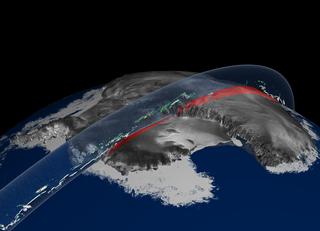
ICESat Lithograph
|
This still image was generated to be printed as a lithograph for public distribution. [from the litho:] This image illustrates ice sheet elevation and cloud data from ICESat's Geoscience Laser Altimeter System (GLAS) on its first day of operation, February 20, 2003. On that day, the instrument collected a 1064 nm wavelength profile across Antarctica: the lower West Antarctic Ice Sheet in the foreground is separated from the higher East Antarctic Ice Sheet in the background by the steep TransAntarctic Mountains. The elevation profile (in red) is depicted relative to the Earthandapos;s standard ellipsoid with 50x vertical exaggeration. Data collected across floating sea ice and open water of the adjacent Southern Ocean cannot be shown at this scale. Clouds of various thicknesses are indicated by colors changing progressively from light blue (thin clouds) to white (opaque layers). Note that the laser cannot penetrate the thickest clouds causing gaps in the elevation profile below. The RADARSAT (Canadian Space Agency) mosaic is used to illustrate the Antarctic continent.
|
|
|
|
A view of Antarctica showing ice sheet elevation and cloud data from ICESat
Available formats:
2700 x 1950
TIFF
4 MB
160 x 80
PNG
22 KB
320 x 231
JPEG
9 KB
80 x 40
PNG
11 KB
|
| Animation Number: | 2978 |
| Animators: | Greg Shirah (Lead) |
| | Alex Kekesi |
| Studio: | NASA |
| Completed: | 2003-11-18 |
| Scientist: | Chris Shuman (NASA/GSFC) |
| Instrument: | ICESat/GLAS |
| Data Collected: | ICESat GLAS: 2003/02/20 |
Keywords:
SVS
>> Ice
SVS
>> Topography
|
|
Please give credit for this item to
NASA/Goddard Space Flight Center
Scientific Visualization Studio, RADARSAT mosaic of Antarctica (Canadian Space Agency) |
|
Back to Top
|
|
|
|

