GOES - NO/P is the next series of GOES satellites. The multimission GOES series N-P will be a vital contributor to weather, solar, and space operations and science. The National Aeronautics and Space Administration (NASA) and the National Oceanic and Atmospheric Administration (NOAA) are actively engaged in a cooperative program to expand the existing GOES system with the launch of the GOES N-P satellites.
The Goddard Space Flight Center (GSFC) is responsible for procuring, developing, and testing the spacecraft, instruments and unique ground equipment. NOAA is responsible for overall program, funding, system in-orbit operation, and determining satellite replacement needs.
The GOES N-P series will aid activities ranging from severe storm warnings to resource management and advances in science. GOES N-P data will add to the global community of knowledge, embracing many civil and government environmental forecasting organizations that work to benefit people everywhere and help save lives.
GOES N-P represents the next generation of GOES satellites. A highly advanced attitude control system fosters enhanced instrument performance for improved weather service quality. NASA and NOAA have set a high standard of accuracy for GOES N-P, including data pixel location to two kilometers from geosynchronous orbit.
Some of the new top-level capabilities include:
- A digital Low Rate Information Transmission (LRIT) formatted Weather Facsimile (WEFAX) service
- Expanded measurements for the Space Environment Monitor (SEM) instruments
- A new dedicated channel for the Emergency Managers Weather Information Network (EMWIN) service
- A more stable platform for supporting improved Imager, Sounder, and SXI instruments
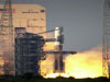
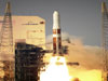
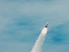
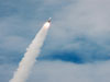
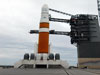
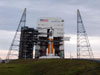
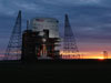
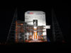
GOES-N, the first spacecraft in the new GOES-N/O/P series, lifted off aboard a Boeing Delta IV rocket from Space Launch Complex 37 at Cape Canaveral Air Force Station, Fla. at 6:11 pm EDT on May 24, 2006.
+ Read more
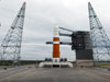
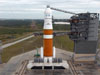
GOES-O is scheduled to launch on April 28, 2009.
GOES N,O,P Enhancement Summary
- GOES N,O,P have an improved Image Navigation and Registration (INR) system that uses star trackers to provide precision image navigation and registration information for use with the Imaging and Sounding data products. This improves knowledge of exactly where severe weather events are located.
- A stable optical bench is provided to isolate thermal deformations of the spacecraft from the Imager and Sounder instruments.
- A data product improvement is provided with the development of the digital Low Rate Image Information Transmission (LRIT) system for distribution of data Products that were distributed in an analog WEFAX format in the previous generation of GOES-I/M satellites. The LRIT system permits the transmission of data products consistent with the World Meteorological Organization (WMO) and permits the distribution of more National Weather Service (NWS) information at a higher data rate to the NOAA data user community.
- The Data Collection System (DCS) is enhanced with the addition of 300 and 1200 bps Data Collection Platforms (DCPs) that use 8-PSK modulation and a higher power satellite transponder so that more DCPs can use the link at the same time.
- The power subsystem is improved with the use of a single panel solar array that contains high-efficiency dual-junction gallium-arsenide solar cells. A nickel-hydrogen battery is provided to permit the satellites to operate during the eclipse periods.
- A new Solar X-Ray Imager (SXI) developed by the Lockheed Martin Advanced Technology Center permits the observation and collection of solar data products.
- A dedicated transponder is provided to support the Emergency Manager’s Weather Information Network (EMWIN) data product service.
- The Satellite design life time has improved from 7 to 10 years, and the expected propellant lifetime has increased to 13.5 years.
- The GOES-N,O,P command data rate increased to 2,000 bps, as compared to a data rate of 250 bps for the previous generation of GOES-I/M satellites.
- The GOES-N,O,P telemetry data rate improved to provide data at either 4,000 or 1,000 bps, as compared to the 2,000 bps data rate on the previous generation of GOES-I/M satellites.
- An optional operational “yaw flip” capability and procedure was developed on the GOES-N,O,P Program to permit optimum performance of the Imager and Sounder radiation coolers. The procedure permits operation of the Imager and Sounder detectors at a lower temperature and results in lower noise performance of the instruments.
- The Space Environment Monitoring (SEM) subsystem is enhanced by the addition of the Extreme Ultraviolet (EUV) sensor, Energetic Proton, Electron, and Alpha particle Detector (EPEAD), the Magnetospheric Electron Detector(MAGED), the Magnetospheric Proton Detector (MAGPD) and dual magnetometers on a 27.9 foot (8.5 meter) long boom. The Energetic Particle Sensors are improved on GOES-N,O,P to provide coverage over an extended energy range and with improved directional accuracy.
- The communications services are tailored to comply with modern national and international requirements.
- Potential reduction in striping in the image is achieved due to increasing the Imager’s scan-mirror dwell time during the blackbody calibration process from 0.2 seconds to 2 seconds.
- Health and safety concerns related to scanning operations during eclipse periods have been removed because thermal shields have been added to the secondary mirror structure elements for the Imager and Sounder instruments.
- There will be no GOES-I/M era “boom snap” problem on the GOES-N,O,P satellites since the effect was due to the shadow of the magnetometer boom crossing the solar sail boom and a solar sail boom is not used with the GOES-N,O,P satellite design.
|

