|
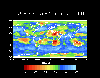
Ozone
data from the Total Ozone Mapping
Spectrometer (TOMS) instruments.
These are the data
that first alerted us to the "hole"
in the ozone layer over the Antarctic.
This data also may be obtained from
the Goddard
DAAC. |
 |
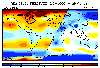
Surface
Solar Energy data set.
From
the Langley DAAC. This Surface
Solar Energy (SSE) data set is a by-product
of the World Climate Research Program
/ Surface Radiation Budget (WCRP/SRB)
satellite-derived global shortwave
data set. |
 |
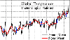
The
CO2 record from the Mauna
Loa, HI observatory.
This
record is one of the longest continuous
CO2 records available.
Appropriate for all ages. |
 |
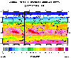
Global,
National, & Regional Anthropogenic
CO2 Emissions from 1751-1999.
Regional
divisions and country
codes are also available. |