Skip all navigation 
and jump to content Jump to site   
    navigation Jump to section navigation
Jump to current   
   event information
NASA Logo - Goddard Space Flight Center    + NASA Homepage
TRMM Tropical Rainfall Measuring Mission
TRMM introduction TRMM news TRMM PUBLICATIONS LISTS SEARCH TRMM TRMM CONTACTS TRMM science data ordering NASA IMAGE POLICY
Current Heavy Rain, Flood and Landslide Estimates
(Rain information from Real-Time TRMM Multi-Satellite Precipitation Analysis [TMPA/3B42])

See TEXT REPORT of areas with estimates of severe flooding near weather station locations

latest dtg
(Observation Time of Last Data Processed)
Point & Click 24 HR Rain Values
Point & Click 72 HR Rain Values
Point & Click 168 HR Rain Values
threshold based flood potential link
See HEAVY RAIN AREA maps.
landslide link
See Potential LANDSLIDE maps.

(CLICK TO SEE) TROPICAL CYCLONE NARGIS QUICKTIME ANIMATION (14.3 MB)
(CLICK TO SEE) TROPICAL CYCLONE NARGIS MPEG ANIMATION (3.8 MB)

Click on the maps below for regional displays with more information
Click here for more DETAILED maps !
Click to see a FULL GLOBE HYDROLOGICAL MODEL FLOOD POTENTIAL IMAGE
Click here for more DETAILED maps !
NOTE: Most Tropical cyclone positions are from the NOAA Tropical Storm Position and Intensity Page.


GOOGLE EARTH DOWNLOADS

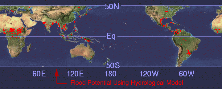
CLICK on the KML file below to download a file which show a REAL-TIME FLOOD POTENTIAL image using GOOGLE EARTH.

Updated March 1, 2007 (Note: you must have Google Earth installed in order to be able to load these KML files.) http://trmm.gsfc.nasa.gov/trmm_rain/Events/trmm_google_hydro_model.kml

LET ME KNOW ABOUT PROBLEMS OR GIVE SUGGESTIONS --> Harold.F.Pierce@nasa.gov

FirstGov logo + NASA Privacy, Security, Notices NASA logo

Curator: Harold.F.Pierce@nasa.gov
Web page design Last Updated by Hal Pierce on: Tuesday May 13 , 2008

NASA Official: Dr Scott A. Braun

NASA Home Page alt="Goddard Space Flight Center Home Page">