Skip all navigation 
and jump to content Jump to site   
    navigation Jump to section navigation
Jump to current   
   event information
NASA Logo - Goddard Space Flight Center    + NASA Homepage
TRMM Tropical Rainfall Measuring Mission
TRMM introduction TRMM news TRMM PUBLICATIONS LISTS SEARCH TRMM TRMM CONTACTS TRMM science data ordering NASA IMAGE POLICY
link to quicktime animation showing  a recent PR SLICE
The images on the right are examples of hurricane and typhoon (tropical cyclone) rainfall analyses. The first example is a plan view showing the distribution of rainfall accumulation near a tropical cyclone. The second panel example shows the time-radius distribution and the time-azimuthal distribution of rainfall near the same tropical cyclone. These analyses use the 3B42 global rainfall estimates. The technical point of contact for information about the images on the right is Dr Scott Braun.You can see many other plots for storms in the Atlantic, Pacific, and Northern Indian Ocean by clicking on the relevant area on the map below.

Click Ocean Basins On The Map Below To See Tropical Cyclone Rainfall Plots
this is a clickable map


The image below is the result of automatic processes designed to show the latest hurricanes and typhoons (tropical cyclones) observed by the TRMM satellite. The images are made and stored in near "realtime". TRMM VIRS, TMI and PR are processed for use in these displays. The "A" to "B" line on the static image on the left below is drawn where the highest value of radar reflectivity was found. Animations show multiple vertical cross sections (slices) of Precipitation Radar reflectivity.
Link to latest tropical cyclone Precipitation Radar image
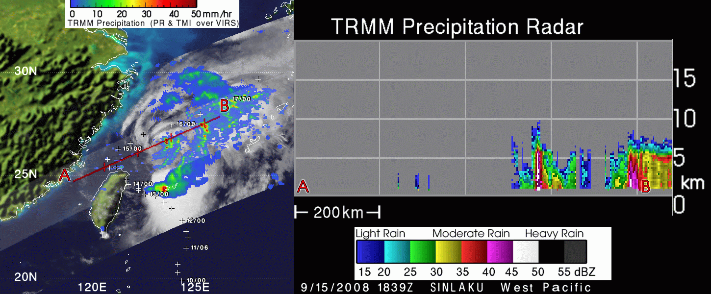
Latest Tropical Cyclone from TRMM Precipitation Radar

click to SEE ALL 2008 STORMS
click to see LATEST ATLANTIC STORMS
VERY LARGE [8.0 mb] Quicktime animation LARGE [4.0 mb] Quicktime animation
click to see 2007 Precipitation Radar vertical slice animations

click to see 2006 Precipitation Radar vertical slice animations

click to see 2005 Precipitation Radar vertical slice animations
FirstGov logo + NASA Privacy, Security, Notices NASA logo

Curator: Harold.F.Pierce@nasa.gov
NASA Official: Dr Scott A. Braun
Last Updated: Thursday November 16, 2006

NASA Home Page alt="Goddard Space Flight Center Home Page">