SURGE IN ATLANTIC ACTIVITY COINCIDES WITH PEAK OF HURRICANE SEASON
The recent flurry of tropical cyclones in the Atlantic is a reminder that we are now
entering the climatological peak of the Atlantic hurricane season. The 2008 season is
turning out to be well above average so far. Following close on the heels of Hurricane
Gustav, which hit the southern Lousiana coast as a category 2 storm on the morning of
September 1st, are Hanna, Ike and Josephine, the 8th, 9th, and 10th named storms of
the season. On average there are 10 named storms for the entire season, which
officially runs through the end of November. Ike became a category 4 storm on the
evening of September 3rd, making it the 3rd major and 5th overall hurricane of the
season; typically there are 6 hurricanes in the Atlantic in any given year with 2 or
3 becoming major. Currently, Hanna, Ike and Josephine all remain active in the Atlantic.
The first of these storms, Hanna, originated from an area of low pressure associated
with an African easterly wave (AEW) that had propagated across the central Atlantic.
There are about 60 of these westward-moving waves in a given year, but only a fraction
develop into tropical cyclones in the Atlantic. This particular wave became more organized
as it neared the Leeward Islands in the Lesser Antilles and was designated a tropical
depression (TD #8) by the National Hurricane Center (NHC) on the morning of August 28th.
Soon after it was upgraded to a tropical storm and given the name Hanna. The Tropical
Rainfall Measuring Mission satellite (also known as TRMM) has been in service for over 10
years now and continues to provide valuable images and information on tropical cyclones
around the Tropics using a combination of passive microwave and active radar sensors.
TRMM was able to capture the recent surge in tropical activity in the Atlantic.
|
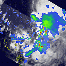
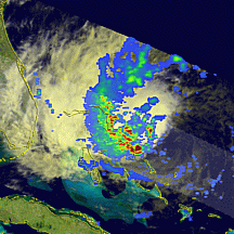
TRMM obtained this first image of Hanna at 22:58 UTC (6:58 pm EDT) 28 August 2008 as
the storm was nearing the northern Leeward Isles. It shows the horizontal pattern of
rain intensity within the storm. Rain rates in the center swath are based on the TRMM
Precipitation Radar (PR), and those in the outer swath on the TRMM Microwave Imager (TMI).
The rain rates are overlaid on infrared (IR) data from the TRMM Visible Infrared Scanner
(VIRS). At this time, Hanna is still only weakly organized. No eye is present and the
rainbands (lines of blue and green areas with isolated areas of red indicating light to
moderate and heavy rain, respectively) show very little evidence of banding (curvature).
|
|
The storm is also highly asymmetric with most of the rain occurring in the eastern half
of the storm. The center of circulation is acutally located near the northwestern-most
area of moderate rain in the TMI swath. These characteristics all indicate that Hanna's
circulation is still in the developing stage and still fairly weak. At the time this
image was taken, Hanna's maximum sustained winds were reported at 35 knots (~40 mph) by
NHC, equivalent to a minimal tropical storm.
Over the next few days, Hanna continued to move to the west-northwest remaining well
north of Puerto Rico and Hispaniola as a moderate tropical storm. After reaching the
Caicos and Turks Islands north of Haiti on September 1st, Hanna came under the combined
influence of a large low pressure system located off of the northeastern US and a
strengthening area of high pressure over the eastern third of the country. A channel
of northerly flow wrapping around the backside of the low and ahead of the high pressure
began to push Hanna southward towards Haiti.
|
The next image from TRMM was taken at
14:18 UTC (10:18 am EDT) on September 1st just as Hanna was beginning to turn south
towards Haiti. Althought the storm is still highly asymmetric (note most of the rain
is still east of the center), there is a substantial area of intense rain (shown by the
darker reds) near the center. Associated with this area of intense rain are deep convective
towers. Known as a convective burst, these are often a sign that the storm is about
to strengthen as they release large amounts of heat (known as latent heat) into the
storm. This heating is what drives the storm's circulation. So despite coming under
the influence of northerly wind shear, some of which was due to outflow from Gustav in
the Gulf of Mexico, Hanna managed to intensify into a category 1 hurricane about 3 hours
later. Hanna remained a hurricane until the next morning when it finally succumbed to
the wind shear and was downgraded to a tropical storm north of Haiti.
|
|
|
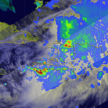
The next TRMM image
was taken at 13:22 UTC (9:22 am EDT) on September 2nd after Hanna was downgraded to a
tropical storm. The storm is still asymmetric (the center is located near Great Inagua
Island in the southeastern Bahamas above the Windward Passage between Haiti and Cuba),
but some of the banding that was evident in the previous image is now gone. Despite losing
some of its intensity, Hanna turned out to be devasting for Haiti as the center of the
storm meandered just north of Hispaniola for 2 days, bringing torrential rains to the
area.
|
|
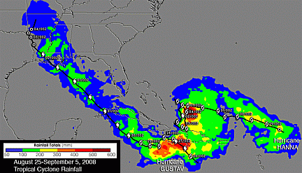 TRMM can be used to calibrate rainfall estimates from other satellites. The TRMM-based,
near-real time Multi-satellite Precipitation Analysis (TMPA) at the NASA Goddard Space
Flight Center provides estimates of rainfall over the global Tropics. TMPA rainfall
totals associated with the recent tropical cyclone activity are shown here for the period
25 August to 5 September 2008 for the western tropical Atlantic and southeastern US. The
highest rainfall totals for the period are over southern and central Haiti and exceed
between 300 and 400 mm (~12 and 16 inches, shown by the orange and red areas, respectively).
Some of this rain can be attributed to Gustav, which tracked across Cuba and the Gulf
ofMexico into Lousiana. So far the death toll from Hanna stands at 137 in Haiti with
most of the deaths reported near the port city of Gonaives.
TRMM can be used to calibrate rainfall estimates from other satellites. The TRMM-based,
near-real time Multi-satellite Precipitation Analysis (TMPA) at the NASA Goddard Space
Flight Center provides estimates of rainfall over the global Tropics. TMPA rainfall
totals associated with the recent tropical cyclone activity are shown here for the period
25 August to 5 September 2008 for the western tropical Atlantic and southeastern US. The
highest rainfall totals for the period are over southern and central Haiti and exceed
between 300 and 400 mm (~12 and 16 inches, shown by the orange and red areas, respectively).
Some of this rain can be attributed to Gustav, which tracked across Cuba and the Gulf
ofMexico into Lousiana. So far the death toll from Hanna stands at 137 in Haiti with
most of the deaths reported near the port city of Gonaives.
Hanna finally began to move northward away from Haiti on the 3rd of September as the
upper-low off of the northeastern US pulled away and high pressure built back in across
the western Atlantic. The storm then took a turn to the northwest on the evening of the
3rd, which placed it on a path near the central and northern Bahamas and eventually to
the southeastern coast of the US.
|
The last TRMM image of Hanna was collected at 19:42
UTC (3:42 pm EDT) on the 4th of September as Hanna was moving to the northwest through
the northeastern Bahamas. Due to southerly wind shear, the bulk of the rain is now
located north and east of the low-level circulation (identified by the swirl in the
low-level clouds shown in gray as opposed to the high clouds shown in white that are
collocated with the rain). At the time of this image, NHC reported that Hanna's
maximum sustained winds were 55 knots (~63 mph). Hanna is expected to gain a little
more strength as it passes over the warm waters of the Gulf Steam, making it a strong
tropical storm or possibly a minimal hurricane before it reaches the Carolina coast
Friday night.
|
|
Meanwhile, Hurricane Ike, a much more powerful storm, continues to loom in the central
Atlantic. Ike also began as an AEW that emerged off of the coast of Africa on the night
August 28th. Ike became a depression on the 1st of September while it was in the central
Atlantic far from land. It was upgraded to a tropical storm later that same day. Ike
remained a tropical storm for the next two days as it steadily made its way to the west-
northwest through the central Atlantic. On the afternoon of September 3rd, however, Ike
began a rapid deepening cycle, which brought it from a tropical storm to a category 4
hurricane with sustained winds estimated at 125 knots (~144 mph) in less than 24 hours.
|
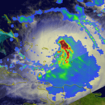
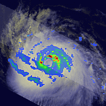
TRMM snapped this image of Ike just as it was becoming a hurricane. The image was taken
as 19:03 UTC (3:03 pm EDT) on the 3rd of September. Ike is a rather small storm, but it
already has a well-defined eye in the rain field (the whole in the center) with tightly-
curving rainbands surrounding the center. Areas of intense rain (dark red) are embedded
in the northern and western eyewall. Ike's cloud pattern is very symmetric with good
outflow. All of these are signs that the storm already has a well-developed circulation.
Ike remained a small but powerful category 4 storm on the 4th before weakening back down
to a category 3 storm on the morning of the 5th due to increasing northeasterly wind shear.
Ike is expected to take a more west-southwesterly track through the Turks and Caicos and
southern Bahamas. It could regain some strength and possibly make landfall in southern
Florida or even enter the Gulf of Mexico.
See a 3-D flyby animation of hurricane IKE using TRMM Precipitation Radar data.
|
|
Images by Hal Pierce (SSAI/NASA GSFC) Captions by Steve Lang (SSAI/NASA GSFC)
The Tropical Rainfall Measuring Mission (TRMM) is a joint mission between NASA and the Japan Aerospace Exploration Agency (JAXA) designed to monitor and study tropical rainfall.