
Northern Rocky Mountain Science Center (NOROCK)
Home | About Us | Science | Product Library | News & Events | Staff | Students | Partners | Contact Us
Northern Rocky Mountain Science Center (NOROCK)
Home | About Us | Science | Product Library | News & Events | Staff | Students | Partners | Contact Us
For full text of thesis Whitebark Pine (Pinus albicaulis) decline and restoration in Glacier National Park, Montana
Introduction
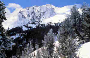 Whitebark (Pinus albicaulis) and limber (P. flexilis) pine are keystone species in the Northern Rocky Mountains, including Glacier National Park (Glacier NP). Wildlife species such as black bears (Ursus americana), Clark's nutcrackers (Nucifraga columbiana), red squirrels (Tamiasciurus hudsonicus), and grizzly bears (Ursus arctos horribilis) eat the large pine seeds produced by these trees. The seeds are especially significant in grizzly bear ecology. These seeds are high in fats and are a highly preferred, and thus important food for grizzly bears who feed on pine seeds found in squirrel middens. The seeds are such a critical food for grizzly bears in the Greater Yellowstone Ecosystem that reproduction and survival are positively correlated with whitebark pine cone crop (Mattson, 1987; Mattson et al., 1992). The location of most whitebark pine stands in remote subalpine environments also means that bears feeding on pine seeds are removed from human activity, reducing the potential for bear-human conflict. In addition to their importance to wildlife, whitebark and limber pine provide a hydrological benefit. Their spreading crowns and ability to grow on windy ridges result in snow accumulation and retention in drainages below (fig.1). These attributes provide for higher, deeper snowpack and delayed meltoff.

 Despite the importance of these tree species, the number of whitebark and limber pine has declined precipitously in Glacier NP and Waterton Lakes National Park; currently 30-100% of the trees are dead in many areas (Kendall and Schirokauer, 1997). Of the remaining live trees, only a small fraction are healthy and producing seed bearing cones as white pine blister rust (Cronartium ribicola; fig. 2) tends to kill the tops of trees first (cones are produced on the top portion of the tree's crown). Fire suppression and resultant large mountain pine beetle (Dendroctonus ponderosae; fig. 3)
 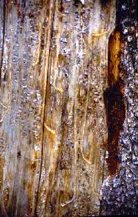 epidemics are also factors contributing to the decline (Morgan and Bunting, 1989; Murray, 1994; Tomback, 1995).
Historically, fire played an integral role in providing suitable regeneration habitat for whitebark pine by removing competing species, such as subalpine fir (Abies lasiocarpa) and Engelmann spruce (Picea engelmannii), and providing necessary abiotic conditions. In addition to being slightly more resistant to creeping ground fire than are other forest communities, whitebark pine is also adapted to harsh climates and can thrive in the exposed and dry post-fire conditions. Furthermore, the open areas produced by fires attract Clark's nutcrackers, which prefer these areas to cache their harvested whitebark pine seeds. This transport of whitebark pine seeds into large burns gives whitebark pine a competitive advantage over wind-dispersed seed species.
As a result of fire suppression, subalpine fir and (less commonly) Engelmann spruce are replacing seral whitebark communities (Kendall, unpublished data). It is increasingly clear that past prescribed natural fire programs have been unsuccessful in returning fire to whitebark pine communities and that a more active prescribed fire program along with a program of seed collection and outplanting is needed to restore these communities.
As the first step in a reevaluation of fire management policies, studies were conducted by Barrett from 1982 to 1996. These studies culminated in fire history (or stand age) maps of Glacier NP (Barrett, 1983, 1986, 1988, 1993, 1997), which are now available from Glacier NP as a GIS layer (produced by Richard Menicke and Carl Key). In a summation of his first study of the North Fork region, Barrett (1983) states, "...the North Fork forests are approaching or have just exceeded the upper limits of their past range of fire intervals....park managers still have the opportunity to reintroduce fire into the [region] before substantial ecological impacts occur." In his later fire history reports that cover other areas of the Park, Barrett continued to emphasize the need to allow fire to play its historic ecological role. More recently, a study of whitebark pine communities in Glacier NP conducted during the past two years underscores the need to reintroduce fire (Kendall and Schirokauer, 1997). As a result of these studies, Glacier NP managers are committed to this goal.
With discussion of a more active prescribed fire program within Glacier NP and in light of the decline of whitebark pine communities and movement toward a more aggressive fire program in Glacier NP, there is a need for spatial data to assist fire or land managers in forming prudent and ecologically beneficial fire prescriptions for whitebark communities. Much of the information needed to construct such a spatial database has already been gathered by Kendall and Barrett. Currently, Kendall is using her whitebark pine vegetation plot data and ARC/INFO to create a map of the distribution and status of whitebark pine and other subalpine forest communities. The National Park Service (Barrett's stand age data), the Biological Resources Division, USGS (Kendall's whitebark pine community structure GIS data), and the US Forest Service (experience with whitebark pine community prescribed burns) each have important components of this information.
Objectives
The goal of this project is to initiate the restoration of whitebark pine communities in Glacier NP through the identification and prioritization of whitebark pine stands to be targeted in a prescribed fire program. Primary products include hardcopy maps (of various scales) and a spatial database identifying and prioritizing areas where whitebark pine communities would benefit from prescribed burns. This information, in conjunction with suggestions from fire management specialists in Glacier NP and other forest fire authorities, will be used to develop a prescribed fire management strategy for whitebark pine communities. A final report will be produced describing an ecologically beneficial fire management strategy for whitebark pine.
Procedures
The following steps utilize ARC/INFO GIS (and ARCVIEW GIS when noted). All GIS layers were borrowed from the Park Service GIS map library at Glacier National Park, except where specified.
This step identifies habitat conducive to whitebark pine regeneration. These layers can be used after prescribed fire to identify sites where restoration efforts may be concentrated. Potential, dominant, seral whitebark pine habitat is identified through a multivariate analysis of slope, elevation, and aspect, using ECODATA plots preformed by Kendall (1995-1997) as sample points. A physiographic GIS stack (containing aspect, slope, and elevation grids; fig. 4a) was derived from the Glacier National Park DEM (Digital Elevation Model). In order to include only habitat dominated by coniferous forest above 5000 feet elevation two masks were created (fig. 4b). Analysis of the resultant stack and Kendall’s habitat type point data created multivariate class signatures of habitat types (fig. 5). Kendall’s whitebark pine ECODATA from the 1995-1997 field seasons provided the point data for the derivation of class signatures. The class signatures were applied to the physiographic stack, which resulted in a raster coverage of dominant seral whitebark habitat and all other habitat. This grid was reclassified to show only dominant, seral, whitebark habitat (fig. 6).
Contiguous Area
Potential whitebark pine habitat with greater contiguous area receives higher prioritization. This assessment is to be done on both the subdistrict and park-wide scales (fig. 6).
Time Since Last Fire
The stand age maps resulting from Barrett’s fire history studies (1983, 1986, 1988, 1993, and 1997) will be overlaid over the potential whitebark pine habitat layer. Whitebark pine habitat of greater stand age (reflecting a greater time since last fire) is prioritized higher. This prioritization will be performed at the subdistrict and park-wide scales, as well.
Canopy Cover
Canopy cover (CC) is assessed to determine how well an area could support a stand replacing crown fire. Caroline Lansing (personal communication), Glacier NP Prescribed Fire Specialist, offered that denser forest canopies carry preferred stand replacing fires better. This attribute will be interpreted from 1997 color infrared aerial photos and DOQ’s (digital orthoquads) of Glacier NP. These values (0-9%CC = None, 10-39% = Low, 40-69% = Moderate, 70-100% = High; based on ECODATA protocol) shall then be added to the potential whitebark pine habitat layer, generating a layer prioritized by canopy cover. Prioritization will be done on the same geographic scales as above.
Prioritization for both geographic scales will be represented graphically in color as a GIS layer and in a GIS database. The three prioritized coverages created in the above step are compiled to yield a single prioritized coverage.
The final GIS product, designed especially for fire and resource managers, will be presented in ArcView Project format. Eleven views shall be provided - one each of the ten subdistricts and one of the entire park. Each view includes a prioritized whitebark pine habitat layer, and other layers such as facilities, park boundaries and adjacent ownership, fire breaks (lakes, rivers, snow, ice, and barren areas), park boundaries, trails, backcountry campsites, bald eagle nesting sites, sensitive plants, and sites of cultural significance (archeological sites). Hardcopy maps of these same areas will be produced.
A final written report will be made available outlining procedures, justifications, analysis, results, and recommendations.
Data Handling and Analysis
The whitebark pine ECODATA collected by Katherine Kendall (1995-1997) is located on the Glacier NP computer network. This data, in MS Access form, has been error checked. All GIS data sources listed herein are located on the Sparc5 Unix machine in the Glacier Field Station, West Glacier, MT. GIS layers of Glacier NP and surrounding area necessary to this project include: DEM, DOQ’s, forest covertype, fire history of the west side, fire history of the Hudson Bay Drainage, fire history of the Missouri River Drainage, bedrock geology, WSAL forest cover type, archeological points, bald eagle nesting sites, sensitive and rare plants, park boundaries, facilities, lakes, land ownership, roads, hydrology, and trails. Color infrared aerial photographs are filed at the Glacier Field Station, as well.
Users
Technology Transfer
The finalized ArcView project will be available on Glacier NP’s computer server, which is accessible to park staff. It will be designed specifically for the fire and resource managers of Glacier NP. The final report shall be on file in Glacier NP headquarters. Papers and posters regarding analysis and results will be presented at various symposia and conferences.
Work Schedule
| GIS Procedure Analysis on Sample Area (Logging Lake Drainage) | 5/26-6/12/98 |
| Sample Area Field Verification | 6/15-6/19/98 |
| GIS Analysis for Entire Glacier NP | 6/22-7/10/98 |
| Development of ArcView GIS Project and Map Production | 7/27-8/14/98 |
| Drafting of Final Report and Recommendations | 8/17/98-4/30/99 |
Product Schedule
| Completed ArcView project and Hardcopy Maps | 8/14/98 |
| Poster presented at Whitebark Pine Restoration Symposium, Missoula, MT | 9/12-9/15/98 |
| First Draft of Final Report | 3/99 |
| Final Report | 5/99 |
Principal Investigator:
Kristopher Peterson, Ecologist USGS Glacier Field Station, Science Center, Glacier National Park, West Glacier, Montana 59936 Phone: (406) 888-7988 Fax: (406) 888-7990. Email: kris_t_peterson@usgs.gov.
Collaborators:
Dr. John Anderton, Assistant Professor of Geography, Department of Geography, Northern Michigan University, Marquette, MI 49855. Phone: (906) 227-2500.
Katherine C. Kendall, Research Ecologist, USGS Glacier Field Station, Science Center, Glacier National Park, West Glacier, MT 59936-0128. Phone: (406) 888-7994 Fax: (406) 888-7990 Email: katherine_kendall@usgs.gov.
Caroline Lansing, Prescribed Fire Specialist, Fire Cache, Glacier National Park, West Glacier, MT 59936. Phone: (406) 888-7810 Email: caroline_lansing@nps.gov.
David Schirokauer, Biologist/GIS Specialist, Point Reyes National Seashore, Point Reyes Station, CA. 94956 Phone: (415) 663-8522 x296 Email: david_schirokauer@nps.gov.
References:
Barrett, S. W. 1983, 1986, 1988, 1993, 1997. Fire History of Glacier National Park, MT. [Contract completion reports on file, Glacier National Park Research Office, Montana.]
Caprio, Anthony, Corky Conover, MaryBeth Keifer, and Pat Lineback. 1997. Fire Management and GIS: A Framework for Identifying and Prioritizing Fire Planning Needs. Paper presented at Fire in California Ecosystems: Integrating Ecology, Prevention, and Management, Bahia Hotel, San Diego, CA, November 17-20, 1997.
Hansen-Bristow, Katherine, Clifford Manotagne, and Ginger Schmid. 1990. Geology, Geomorphology and Soils Within Whitebark Pine Ecosystems. pp. 62-71. In Proceedings - Symposium on Whitebark Pine Ecosystems: Ecology and Management of a High-Mountain Resource, USDA, Forest Service, Intermountain Research Station, General Technical Report INT-270, June 1990.
Kendall, Katherine C., and David Schirokauer. 1997. Alien Threats and Restoration Dilemmas in Whitebark and Limber Pine Communities, Paper presented at the George Wright Forum, Santa Fe, NM, March 17-21, 1997.
Lasko, Richard J. 1990. Fire Behavior Characteristics and Management Implications in Whitebark Pine Ecosystems. pp. 319-323. In Proceedings - Symposium on Whitebark Pine Ecosystems: Ecology and Management of a High-Mountain Resource, USDA, Forest Service, Intermountain Research Station, General Technical Report INT-270, June 1990.
Mattson, D.J. 1987. Habitat Dynamics and Their Relationship to Biological Parameters of the Yellowstone Grizzly Bear. 1977-83 Progress Report, Interagency Grizzly Bear Study Team. Gardner, MT. 28 pp.
Mattson, D.J., et al. 1992. Yellowstone Grizzly Bear Mortality, Human Habituation and Whitebark Pine Seed Crops. J. Wildl. Manage. 56 (3): 432-442.
Morgan, Penny. and Stephen C. Bunting. 1989. Fire Effects in Whitebark Pine Forests. Paper presented at the Symposium on Whitebark Pine Ecosystems: Ecology and Management of a High-Mountain Resource, Bozeman, MT, March 29-31, 1989.
Murray, Michael. 1994. Whitebark Pine/Fire Relationships Within a Small Roadless Area: Preliminary Findings, Nutcracker Notes, 4: 9-10.
Peterson, Kristopher T. 1999 Whitebark Pine (Pinus albicaulis) decline and restoration in Glacier National Park, Montana Thesis. University of North Dakota, Grand Forks, ND.
Tomback, Diana. 1995. Whitebark Pine Communities in the Northern Greater Yellowstone Ecosystem: Patterns of Regeneration Since the 1988 Fires. Nutcracker Notes, 6: 12-13.
Content Information Contact:kris_t_peterson@usgs.gov
