PMEL Programs and Plans
Accomplishments in FY 97 and Plans for FY 98
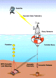
Figures (a) Real-time tsunami reporting system for early detection of tsunamis
and for assessing and forecasting the threat tocoastal communities, and
(b) Tsunami amplitudes produced by a remotely-generated teletsunami near Shikotan Island,
northeast of Japan.
Tsunami Project
Accomplishments in FY 97
The PMEL Tsunami Project seeks
to mitigate tsunami hazards to Hawaii, California, Oregon, Washington, and Alaska
through research aimed at improving operational products. Research efforts involve
three tightly coupled programs: instrumental, observational, and modeling. These
programs are designed to improve our fundamental understanding of tsunami generation,
propagation, and inundation
dynamics. The project applies this research to hazard mitigation, including the
development of improved site-specific tsunami inundation maps and a real-time
reporting tsunami measurement system.
All FY 97 Tsunami Project Plans were completed. Much of this work was
performed as part of two major efforts: the National Tsunami Hazard
Mitigation Program and
the
Early Detection and Forecast of Tsunamis Project.
PMEL/NOAA has been identified as the nation's lead organization for implementation
of the NTHMP. In FY97: (1) Two real-time tsunami deep ocean measurement systems
were deployed
as part of a joint NTHMP/EDFT effort -- one in the Gulf of Alaska, the other
off the U.S. west coast; engineering efforts to improve the reliability of these
systems continues. (2) The NTHMP's recently established Center for Tsunami
Inundation Mapping Efforts (TIME) assisted the State of Oregon in the production
of inundation maps for the communities of Seaside and Newport. (3) During the
course of the year, three meetings
of the NTHMP Federal/State Working Group were also convened at PMEL.
Also, as part of the EDFT Project, reports were published which
documented each of the following accomplishments. (4) A large database
of records collected during the 10 June 1996 Andreanov tsunami
was developed;
for the first time, a tsunami event database is now publicly available
on the World Wide Web. (5) The Method of Separation Tsunami
numerical model was implemented and tested on the TIME (Tsunami Inundation Mapping Efforts) Center computer system. (6) A near-real-time Hawaii coastal sea level data collection and archiving system was established.
Additionally: (7) Two oceanographic cruises were completed in FY97, in
order to recover and redeploy all bottom pressure recorders
(BPRs) and maintain
the tsunami observational network. (8) Pacific-wide records, including
deep ocean BPR records, were acquired for the 5 December 1997 tsunami
generated by a magnitude 7.7 Mw earthquake off the Kamchatka peninsula.
(9) Two reports were published on the problem of tsunami
forecasting . (10) A
proposal to the Deputy Under-Secretary of Defense for Space Integration,
entitled "Pacific Disaster Center Tsunami Forecasting
Capabilities via the Tsunami Community Modeling Facility"
was developed and approved
for funding.
Tsunami Project
Plans for FY 98
- Coordinate the three agencies and five states participating in the
NTHMP.
- Maintain Tsunami Project network of observational stations
- Recover, refurbish, and re-deploy real-time tsunami deep ocean
measurement systems in the Gulf of Alaska and off the U.S. west coast.
- Assist Washington, Oregon, California and Alaska in the production
of inundation maps for threatened coastal communities.
- Implement and test parallelized version of the MOST numerical
model on the Pacific Disaster Center supercomputer.
- Conduct sensitivity study of the influence of tsunamigenic
earthquake parameters on the characteristics of offshore Hawaii tsunami
waves.
- Convene workshop on development of the proposed Tsunami Community
Modeling Facility.
|