|
||
|
|
||
 | |||
|
|||
Unless you are a toad or a swamp rat, chances are you don’t want to live
on the edge of a smelly, algae-filled lake. Most people like their lakes clean,
clear, and fresh. This is particularly true for those who reside in the Upper
Midwest. Lakes there are central to people’s lives. Not only do they
provide an outlet for recreation and an ideal setting to connect with nature,
but they also draw in the bulk of the tourist trade. No one wants to see the
pristine lake they fish on or swim in become polluted. Unfortunately, monitoring
water quality for the 30,000 plus lakes in the Upper Great Lakes region has
never been possible. Water quality measurements have always been taken by hand,
and the states have traditionally had the resources to monitor only a small
percentage of their lakes. Such modest samplings cannot give researchers a
comprehensive view of water quality throughout the states. |
|||
|
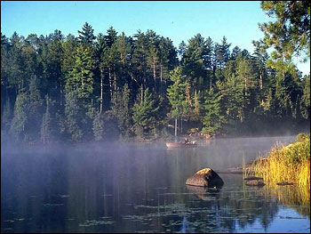
Minnesota is known as the land of 10,000 lakes—a claim which is actually an understatement. Most of these lakes are relatively clean, like Lake Everett, providing the perfect environment for a secluded canoe trip or fishing expedition. Urbanization and agricultural runoff are, however, degrading water quality, particularly in the south of the state. Researchers at the University of Minnesota are developing new techniques to monitor water clarity and lake health, which will help identify trends in water quality. (Photograph copyright Kevin Judd) | ||
Recently, scientists at the University of Minnesota working on a NASA project
arrived at a solution. Using imagery from Landsat satellites, the scientists
have mapped the water clarity for over 10,000 of Minnesota’s lakes at a
relatively low cost. The maps have allowed them to evaluate water quality
patterns across the state as well as provide the tools for monitoring lakes to
the state. In the future, the scientists in Minnesota will combine their map
with similar maps being created at the University of Wisconsin and Michigan
State University to create a comprehensive water quality map for the entire
Upper Great Lakes region. The data used in this study are available in one or more of NASA's Earth Science Data Centers. |
 Satellites can image a much wider area than can be effectively monitored from the ground. This pair of true-color Landsat images compares a clear, clean lake (top) with a lake with poor water quality (lower). (Images courtesy Upper Great Lakes Regional Earth Science Applications Center) |
|
Subscribe to the Earth Observatory About the Earth Observatory Contact Us Privacy Policy and Important Notices Responsible NASA Official: Lorraine A. Remer Webmaster: Goran Halusa We're a part of the Science Mission Directorate |
|
|