Science and Analysis
Humans’ link to the oceans has been essential to our survival.
We rely on the marine ecosystem for food, jobs, recreation, relaxation,
transportation, security, and study. Because we can’t necessarily
see all the riches that lie beneath the water’s surface,
there is much we don’t understand about how species and
habitats are interconnected. Just as we are curious about exploring
the universe around us, we are equally fascinated by the sometimes
mysterious cycle of life in our marine environments, and how it
impacts us. Because of this curiosity, humans are driven to discover
as much as possible about our natural world and how we interact
with its resources.
One issue that has been a popular topic of debate is how to use
marine protected areas (MPAs) to conserve our natural and cultural
marine resources. One of the big questions people often ask about
MPAs is whether or not they really work. This question leads us
to look at existing scientific research, from both natural and
social science, to see what that research is saying about MPAs
on a national level. Since the MPA Center was established in 2001,
it has been using science and analysis to assess the nature of
MPAs and their use in sustaining healthy marine ecosystems. This
has been especially essential to the MPA Center’s work to
develop a national system of MPAs.
In partnership with other government agencies, the MPA Center
has focused its scientific priorities on analyzing gaps in existing
MPAs and their features, characterizing how marine resources are
currently being protected, and facilitating the sharing of scientific
knowledge and products related to these resources.
The following are areas of scientific focus for the MPA Center.
Click on each link to read more.
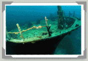
Cultural
and Historic MPA Resources
Marine protected areas can encompass an area that has been set
aside because a ship, aircraft, or other cultural artifact rests
on or is embedded within the sea floor. The knowledge gained through
careful research and analysis of historical artifacts scattered
throughout our oceans and Great Lakes is fundamental to understanding
our heritage. By continuing to preserve, protect, and respect
these non-renewable resources, we can ensure that our nation’s
cultural resources are available for future generations.
Read more.
Social
Science
Human communities are tied to marine environments in many ways.
The coasts and oceans provide people with numerous goods and services
that meet social, cultural, and economic needs. We harvest fish
and shellfish for subsistence, commercial, and recreational use.
We rely on our waterways for commerce, trade, and navigation.
We use our natural resources for energy production, construction,
and scientific research. We are drawn to the shores and beaches
for tourism, leisure, and spiritual and cultural renewal. Understanding
how people use coastal and ocean environments is a critical need
for ecosystem approaches to management. The way people interact
with the marine environment has implications for the health and
well-being of both the human communities and the resources on
which they depend.
Read more.
Ecology
(Natural Science)
Our natural marine environments hold a plethora of inter-connected
species and habitats that rely on each other for health and survival.
In the U.S., a vast range of ecosystems of many sizes hold wonders
that are unique and often mysterious. Our oceans, bays, and Great
Lakes are full of diverse plants, animals, and ecosystems that,
in most cases, we are just beginning to understand.
Read about the Ecological
Characterization Project.
Analysis
of the Nation’s Marine Managed Areas
Using marine managed area data collected from federal, state,
and territories, the MPA Center has completed a preliminary analysis,
the first of its kind in the nation. Some interesting facts and
trends have been revealed by this analysis. For example, of more
than 1,500 areas in the U.S., 90 percent allow access and multiple
uses, such as fishing. In addition, federal sties generally are
larger but most are established and managed by state agencies,
most are permanent and provide year-round protection, and most
were established since 1970. The MPA Center plans to continue
analyzing the data in more detail across different spatial scales
and levels of government as it begins the process to develop a
national system
of marine protected areas.
Read
more about the results of the analysis.
Inventory of U.S. Marine Protected Areas
Drawing from data collected through the analysis of the nation's marine managed areas, the MPA Center has created a comprehensive and inclusive inventory of federal, state and territorial place-based marine conservation efforts in the U.S. The Marine Protected Areas Inventory (MPA Inventory) provides baseline information that will contribute to the development of the National System of MPAs, as defined in the Executive Order. The MPA Inventory also serves as a valuable resource for agencies, managers, scientists, non-governmental organizations, resource users, and the interested public to better understand numerous characteristics about these sites, such as management capabilities, resources protected, and evaluation processes. Read more about the MPA Inventory.
GIS
and Remote Sensing
In order to manage the complex issues affecting the nation's MPAs,
managers often turn to technology for help in understanding and
analyzing the resources and environments of their MPAs. MPA managers
and scientists are increasingly using geographic information systems
(GIS) and remote sensing to map and analyze the resources under
their jurisdiction.
Read more
about GIS and Remote Sensing.
The West
Coast Pilot
The MPA Center is leading a collaborative initiative to pilot
key methods and approaches for developing a regional system of
MPAs on the west coast (California, Oregon, and Washington). This
involves developing, testing, and applying analytical tools, and
gathering the best information, including science-based data and
traditional ecological knowledge, to better understand how to
more effectively use MPAs to sustain healthy marine environments.
The West Coast Pilot is an unprecedented effort that requires
core partnerships among the region’s federal, state, and
tribal government agencies. Key NOAA partners include the National
Marine Sanctuary Program, National Centers for Coastal Ocean Science,
and Fisheries. In addition, the participation of the following
regional partners is instrumental to the effort’s success:
the Department of the Interior’s National Park Service and
Fish and Wildlife Service; the National Estuarine Research Reserves
System; the Pacific Fishery Management Council; tribes; states;
academic institutions; and non-governmental organizations.
Read more about
the West Coast Pilot.
|